- County of Flanders
-
County of Flanders
Graafschap Vlaanderen (nl)Fiefdom of France, then
State of the Holy Roman Empire
part of the Burgundian Netherlands (1384–1482)
part of the Habsburg Netherlands (1482–1581)
part of the Southern Netherlands (1581–1795)← 
862–1795  →
→
→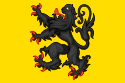
Flag Coat of arms County of Flanders in northern France, 1477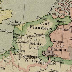
Capital Bruges, later Ghent Language(s) Old Frisian, Old Dutch, Dietsch, Dutch, Flemish Religion Catholic Church Protestantism Government Monarchy Historical era Middle Ages - Fief granted to
Count Baldwin I862 - Acquired by
Duke Philip the Bold1384 - To Maximilian I
of Habsburg1477 - Burgundian Circle 1512 - Renounced by France 1526 - Annexed by France 1795  Topographic map of the county of Flanders at the end of the 14th century, the French-Imperial border marked in red
The County of Flanders (Dutch: Graafschap Vlaanderen, French: Comté de Flandre) was one of the territories constituting the Low Countries. The county existed from 862 to 1795. It was one of the original secular fiefs of France and for centuries was one of the most affluent regions in Europe.
The area under the French crown was located completely west of the Scheldt river and was called "Royal Flanders" (Kroon-Vlaanderen). This fief was finally removed from French control after the Peace of Madrid in 1526 and the Peace of Ladies in 1529. Aside from this the count of Flanders also held land east of the Scheldt river from the 11th century on, as a fief of the Holy Roman Empire; this area was called "Imperial Flanders" (Rijks-Vlaanderen). Except for French Flanders, Flanders is the only part of the medieval French kingdom that is not part of modern day France.
Etymology
Flanders and Flemish (Dutch: Vlaanderen and Vlaams) ultimately go back to unattested Frisian *flāndra and *flāmisk (seen in Old Frisian flamsk ‘Fleming’), the roots of which are Germanic *flaumaz meaning "overflow, flooding". This etymology is appropriate since the coastal area of Flanders was flooded twice per day from the 3rd century to the 8th century by the North Sea at a time when the coast was inhabited by Frisians.
The Flemish people are first mentioned in the biography of Saint Eligius (ca. 590-660), the Vita sancti Eligii. This work was written before 684, but only known since 725. This work mentions the "Flanderenses", who lived in "Flandris".
Geography
The geography of the historic County of Flanders only partially overlaps with present-day Flanders. The land covered by the county is spread out over:
- Belgium:
- France:
- French Flanders (in the Nord departement)
- Artois (in the Pas-de-Calais department): removed from Flanders in 1191 and created as independent county in 1237
- Netherlands: Zeelandic Flanders, a region between Belgium and the Western Scheldt, in the southern part of the province of Zeeland
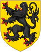
Flag and Arms
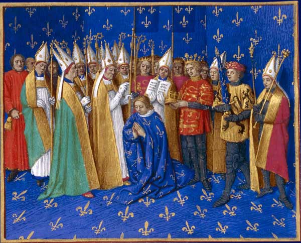
Main article: Coat of arms of Flanders Count Philip (2nd from right) as swordbearer at the coronation of King Philip II of France,
Jean Fouquet, 1455The arms of the County of Flanders were allegedly created by Philip of Alsace, count of Flanders from 1168 to 1191; a climbing or rampant black lion on a gold field. In the story about the Guldensporenslag, the arms and its corresponding battlecry Vlaendr'n den leeuw ("Flanders, the Lion!") plays a crucial role in the forming of a Flemish consciousness, which was popularised in recent times by the book De Leeuw van Vlaanderen by Hendrik Conscience. As a result, the arms of the county live on as arms of the Flemish Community.
It is said that Philip of Alsace brought the lion flag with him from the Holy land, where in 1177 he supposedly conquered it from a Saracen knight, but this is a myth. The simple fact that the lion appeared on his personal seal since 1163, when he had not yet set one step in the Levant, disproves it. In reality Philip was following a West-European trend. In the same period lions also appeared in the arms of Brabant, Luxembourg, Holland, Limburg and other territories. It is curious that the lion as a heraldic symbol was mostly used in border territories and neighbouring countries of the Holy Roman Empire. It was in all likelihood a way of showing independence from the emperor, who used an eagle in his personal arms. In Europe the lion had been a well known figure since Roman times, through works such as the fables of Aesop.
Early history
Ancient and Roman times
The future county of Flanders had been inhabited since prehistory. During the Iron Age the Kemmelberg formed an important Celtic settlement. During the times of Julius Caesar, the inhabitants were part of the Belgae, a collective name for all Celtic and Germanic tribes in the north of Gallia. For Flanders in specific these were the Menapii, the Morini, the Nervii and the Atrebates.
Julius Caesar conquered the area around 54 b.c. and the population was partially romanised from the 1st to the 3rd century. The roman road that connected Cologne with Boulogne-sur-Mer was used as a defense perimeter. In the south the Gallo-Romanic population was able to maintain itself, while the north became a no-mans land that also suffered from regular floods from the North sea.
In the coastal and Scheldt areas Saxon tribes gradually appeared. Saxon was a general term for the Romans, and included Angles, Saxons, Jutes and Erules. The coastal defense around Boulogne and Oudenburg, the 'Litus Saxonicum', remained functional until about 420. These forts were manned by Saxon soldiers.
From their base land Toxandria the Salic Franks further expanded into the Roman empire. The first incursion into the lands of the Atrebates was turned away in 448 at Vicus Helena. But after the murder of the roman general Flavius Aëtius in 454 and roman emperor Valentinianus III in 455, the Salic Franks encounterd hardly any resistance. From Duisburg, king Chlodio conquered Cambrai and Tournai, and he reached the Somme. After his death two Salic kingdoms emerged. Childeric is recorded in 463 as king of Tournay and ally of the Romans against the Visigoths. He was also administrator of the province of Belgica Secunda. His son Clovis I conquered from 486 on all of Northern France.
6th century
The abandoned coast and Scheldt region had been partially repopulated since the 4th century by Saxonian groups that retained their Germanic culture and language. In the 5th century Salic Franks settled in present day Northern-France and Wallonia, primarily around the cities of Courtrai, Tournai and Bavay. They adapted to the local Gallo-Romanic population. From the 6th century on the no-mans-land farther north was filled by Franks from the Rhinelands and other Germanic groups from the Netherlands and Germany.
The first wave of immigration in the present day Flemish territory was accompanied by limited Christianisation. In the wake of the immigrants, missionaries tried to convert the heathen population, but they had little success. The bishoprics were reinstated, usually with the same natural borders of the Late-Roman era; the Silva Carbonaria separated the Bishopric of Cambrai from the Bishopric of Tongeren, while the Scheldt again became the border between the bishoprics of Cambrai and Tournai. Vedastus and Eleutherius of Tournai were assigned to reinstate the bishoprics of Arras and Tournai. However, these bishoprics failed to survive independently. In the late 6th century the bishopric of Atrecht was connected to that of Courtrai, and at the start of the 7th century the same was done to the bishoprics of Tournai and Noyon.
At the end of the 6th century the duchy of Dentelinus was created in the north of what would later constitute Neustria. This duchy presumably included the bishoprics Boulogne, Terwaan, Atrecht, Tournai, Courtrai and Noyon, thus the northwestern region between the North Sea and the Silva Carbonaria, an area whose outlines were very similar to the later Flanders. The duchy of Dentelinus was primarily meant as a military and strategical deterrent against Frisian and Saxon invasions. It was a cornerstone in the military defense of the Merovingian Empire. In 600 Chlotar II (584-628) was forced to temporarily cede the duchy of Dentelinus to Austrasia, but after restoration of Austrasian dual-monarchy in 622/623 the duchy was returned.
7th century
At the end of the 6th and the 7th century a new inflow emerged from the western Pas-de-Calais. This area had been germanised in the 5th century and descendants of the Saxons and Franks had settled in future Flanders and the Duchy of Brabant. New groups of germanic settlers also came in from the Netherlands and Germany. Their new settlements often received the name of their germanic leader, with '-inga haim' added. -Inga haim meant 'the settlement of the tribe of X'. For example: Petegem comes from Petta-inga-haim, which meant 'the settlement of the tribe of Petta'.
The colonisation and germanisation of Flanders took place primarily in the 6th and 7th centuries. In the 7th century the population-level had risen sufficiently to start rebuilding the religious, military and administrative infrastructure. In the area of linguistics, the situation stabilised so that a large, bilingual region with a linear language border could emerge in the 8th century. In Pas-de-Calais, which had been densely populated a long time, a language barrier had emerged in the 6th-7th century, but in the 9th century a romanisation-movement started that has continued until the present day.
The Christianisation attempts in the 6th century by bishops like Eleutherius and Vedastus had largely failed. Thus, in the 8th century a different strategy was chosen. A new Christianisation attempt was made under influence from king Dagobert I. He appointed several devoted missionaries from the southern parts of his kingdom to his royal domains in the northern parts of his kingdom. The missionaries were tasked with founding monasteries and abbeys there, that were to serve as centers of Christianity in a pagan region. From these centers, the conversion of the local populace could be started.
In 649 Audomar founded an abbey at Sithiu (the Abbey of Saint Bertinus) and in 680 Aubertus founded the Abbey of St. Vaast near Arras. The Christianisation of the population was mainly the work of missionaries like Amandus (St. Bavo's Abbey and St. Peter's Abbey in Ghent) and Eligius (coastal region and Antwerp). In his 'vita', Eligius makes the first mention of the word 'Flanders', when he toured the area around 650.
During the 7th century the first Gaue or pagi were created in the Flemish territories. Gaue were administrative subdivisions of the civitates. The Gaue from the 7th and 8th century would form the basis of the county of Flanders. The pagus Tornacensis dates from ca. 580, and from the 7th century we know of the 'pagus Cambracinsis' in 663, the pagus Taroanensis from 649 and the pagus Bracbatensis at the end of the century. From the 8th century we know of the pagus Rodaninsis from 707, the pagus Gandao from the first quarter of the 8th century, the pagus Mempiscus from 723 and the pagus Flandrensis from around 745. Lastly, the pagus Austrebatensis and the pagus Curtracensis are also counted as Merovingian gaue.
Medieval History
The Carolingians
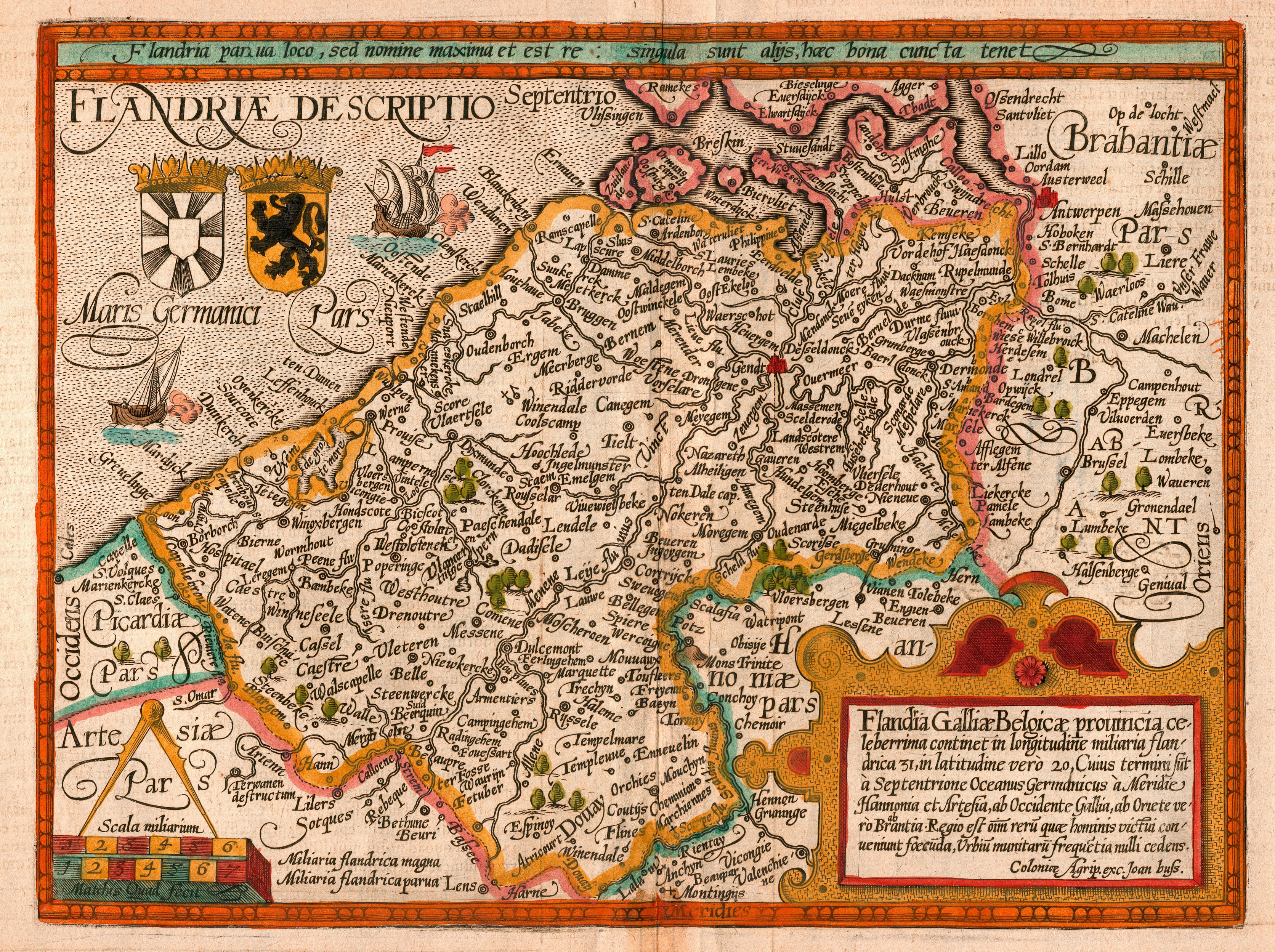
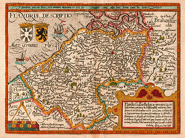 map of the county of Flanders from 1609 by Matthias Quad, cartographer, and Johannes Bussemacher, engraver and publisher, Cologne
In 751 the Carolingian Mayors of the Palace succeeded in removing the Merovingians from power and obtaining the throne for themselves. The last Merovingian king, Childeric III, was placed in captivity at the later Abbey of Saint Bertinus in St. Omer, and his long hair, a symbol of royal power, was cut off.
Charlemagne succeeded his father Pippin the Short in Neustria and Austrasia, and after the death of his brother Karloman he was able to reunite the entire Frankish Empire. Though he resided in Aachen, he spent much time travelling through his territories. In 811 he inspected the fleet that he had ordered built in Boulogne and Ghent, to protect against Viking invasions.
The region comprising future Flanders was, from an economic point of view, a flourishing region, with a series of ports along the Scheldt river: Ghent, Tournai, Valenciennes, Cambrai and Lambres at Douai on the Scarpe and a number of seaports: Quentovic, Boulogne and Isère portus, a port at the mouth of the Yser. Moreover, the region included a number of rich abbeys, such as Abbey of St. Bertin, St. Bavo's Abbey, Saint-Amand Abbey and the Abbey of St. Vaast.
Charlemagne was succeeded by his son Louis the Pious. Even during Louis' life his three sons started fighting over his heritage. They eventually concluded multiple treaties, of which the Treaty of Verdun, signed in 843, would be the definitive treaty. These treaties created East Francia, Middle Francia and West Francia. West Francia, inherited by Charles the Bald, included the original county of Flanders, that spanned roughly between Oudenburg, Aardenburg and Torhout.
After the Middle-Frankish kings died out, the rulers of the West and East-Frankish Kingdoms divided the Middle-Frankish kingdom amongst themselves in the treaty of Meerssen in 870. Now Western Europe had been divided into two sides: the solid West Francia (the later France) and the loose confederation of principalities of East Francia, that would become the Holy Roman Empire.
In the north these two powers were separated by the Scheldt river, which had previously separated West Francia from Middle Francia. This separation remained unchanged until the times of Charles V, Holy Roman Emperor.
Growth in the 9th, 10th and 11th centuries (864-1071)
 Institution of Baldwin I , the first count of Flanders by Charles the Bald, the Frankish king.
Militarily, economically and politically, Europe went through a deep crisis. The Vikings invaded from the north, the Magyar from the east and the Saracens from the south. All left trails of destruction. The central authorities of the two Frankish kingdoms were unable to organise an effective defensive, causing the population to lose faith and trust in their far-removed rulers. In the wake of this power vacuum, local powerful individuals saw their chance. Often these individuals were the descendants of people associated with Charlemagne.
The county of Flanders originated from the Gau of Pagus Flandrensis, led by the Forestiers dynasty, who had been appointed by Charlemagne, who had made a small contribution by uniting small feudal territories in the higher parts of the Flemish Valley. The forestiers dynasty also strengthened the hold of the church on the relatively desolate area.
The first Count of Flanders was Baldwin I of Flanders,[1] who became count in 862, and a romantic anecdote is connected to this: Baldwin eloped with the daughter of the Frankish king Charles the Bald, Judith of West Francia. Judith, who had previously been married to two English kings, refused her father's command to return to him. After mediation by the pope, the Frankish king reconciled with his son-in-law, and gave him the title of count, and the corresponding feudal territories as dowry.
Initially the French kings meant to secure the safety of the northern French border from Viking invasions with this act. The counts, however, made good use of the crisis situation by incorporating the surrounding plundered territories into the county. The counts expanded the influence of the original Flemish pagus over the years over all territories south and west of the Scheldt river, including presentday the lordship of the Four Amts, Zeelandic Flanders, the burgraviate of Aalst to the east and the County of Artois to the south, which remained part of Flanders until it became a separate county in 1237. After that date, the county of Artois at various times still came under the dominion of the count of Flanders as a separate title, until it was absorbed by the French crown.
Prosperity in the 12th and 13th century (1071-1278)
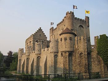 The Gravensteen at Ghent, Built by Philip of Alsace
The House of Flanders stayed in power until 1119, when Baldwin VII of Flanders died heirless, and the county was inherited by Charles the Good, of the House of Denmark. After a short interlude under William Clito of Normandy (1127 to 1128), the county went to Thierry of Alsace of the House of Alsace. Under Thierry (1128–1168) and his successor Philip of Alsace, Flanders' importance and power increased.
In the second half of the 12th century, the county went through a period of great prosperity when Philip of Alsace managed to incorporate the County of Vermandois into Flanders through the inheritance of his wife. The territories he controlled now came to within 25 kilometers of Paris, and were larger than the territories his Feudal Lord, the French King, directly controlled.
During the rule of the House of Alsace, cities developed and new institutions were formed. The ports of Gravelines, Nieuwpoort, Damme, Biervliet, Dunkirk, and Mardijk were founded, as well as Calais by Philip's brother Matthew of Alsace. Aside for colonisation, the ports also functioned to reduce the silting of the Aa, Yser and Zwin rivers, which were endangering the accessibility of Saint-Omer, Ieper and Brugge. Biervliet also served as a counter to Hollandic influence.
Trade partners included England, the Baltic countries and France over sea, and the Rhineland and Italy over land. The wool trade with England was of special importance to the rising cloth industry in Flanders. The wealth of many Flemish cities (as their Belltowers and cloth halls testify) came from the drapery industry. Aside from this, the grain trade with England and through Holland with Hamburg were also important. Saint-Omer became the most important transit-port for French wine in the 12th century. These were the centuries of the breakthrough of the Flemish merchants, with their trade with England, the Baltic area and South-West France, as well as the landrouters to the Rhineland and Italy, though later only the yearly fairs of Champagne. Flanders' flourishing trading towns made it one of the most urbanised parts of Europe.
In 1194, Baldwin I of Constantinople of the House of Hainaut, succeeded the House of Alsace.
The crisis of the 14th century (1278-1384)
In 1278 Guy of Dampierre, of the House of Dampierre, became count of Flanders. The king of France wanted to definitively conquer Flanders, and started the Franco-Flemish War (1297-1305). Increasingly powerful in the 12th century, the territory's autonomous urban centres were instrumental in defeating the French invasion attempt, defeating the French at the Guldensporenslag in 1302.
Flemish prosperity waned in the following century, however, owing to widespread European population decline following the Black Death of 1348, the disruption of trade during the Anglo-French Hundred Years' War (1338–1453), and increased English cloth production. Flemish weavers had gone over to Worstead and North Walsham in Norfolk in the 12th century and established the wool industry.
The Burgundian 15th century (1384-1506)
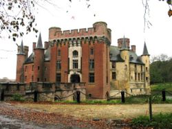
Wijnendale Castle with a view of the medieval part Through his marriage with Margaret of Dampierre in 1369, Philip the Bold, duke of Burgundy, made an end to the independence of Flanders. Flanders became the possession of the House of Valois-Burgundy, that ruled over the Duchy of Burgundy. In 1449 the city of Ghent Revolted against duke Philip the Good. In 1453 Philip crushed the rebels at the battle of Gavere, ending the revolt.
In 1482 the last Burgundian ruler Mary of Burgundy died, making her young son Philip I of Castile of the House of Habsburg the new count, and her husband Maximilian I of Austria the regent.
The seventeen provinces in the 16th century (1506-1598)
Under Charles V, Holy Roman Emperor, Flanders became officially part of the Habsburg Empire in 1506, becoming a member of the Burgundian Circle. The county was later involved in the Guelderian Wars.
Through the Pragmatic Sanction of 1549, the County of Flanders was officially detached from France. It became an independent territory of the Holy Roman Empire. This constitutional act made Flanders part of the Seventeen Provinces, that constituted the Low Countries and from then on would be inherited as a whole.
The Low Countries held an important place in the Empire. For Charles personally, they were the region where he spent his childhood. Because of trade and industry and the rich cities, they were also important for the treasury. Lordship transferred to the Spanish branch of the House of Habsburg with Philip II of Spain, and after 1556 belonged to the Kings of Spain.
It was in Steenvoorde (In French Flanders) in 1566 that the Beeldenstorm broke loose. The Beeldenstorm spread through all of the Low Countries and eventually led to the outbreak of the Eighty Years' war and the secession of the Republic of the Seven United Netherlands. Originally Flanders cooperated with the northern provinces as a member of the Union of Utrecht, but from 1579-1585 it was reconquered by the Spanish army.
See also: Eighty Years' warThe Spanish 17th century (1598-1713)
Flanders stayed under Spanish control. Through the efforts of the French king Louis XIV, the entire southern part of Flanders was annexed by France, and became known as South-Flanders or French Flanders. This situation was formalised in 1678 at the Treaty of Nijmegen.
The Austrian 18th century (1713-1789)
After the extinction of the Spanish branch of the Habsburgs, the Austrian branch of the Habsburgs became counts of Flanders. Under Maria Theresa of Austria, the Austrian Netherlands flourished.
Half a century of Revolutions (1789-1830)
In 1789 a revolution broke out against emperor Joseph II. In 1790 the county of Flanders and a separate province called West-Flanders (1713), which constituted the territories given back by France to the Emperor, were two of the founding members of the United States of Belgium. Just like the other parts of the Austrian Netherlands, the county of Flanders declared its independence. This took place on the Friday-market at Ghent on 4 January 1790. The "Manifest van Vlaenderen" was drawn up by Charles-Joseph de Graeve and Jan Jozelf Raepsaet.
The county of Flanders officially ceased to exist in 1795, when it was annexed by France, and divided into two departments: Lys (present day West Flanders) and Escaut (present day East Flanders and Zeelandic Flanders).
After the French Revolution the county was not restored, and instead the two departments continued their existence as the provinces of East- and West-Flanders in the Unitarian United Kingdom of the Netherlands, and later after the Belgian Revolution in Belgium.
The Kingdom of Belgium (1830)
The title Count of Flanders was annexed by the Belgian Kings and continued to formally exist. As a rule it was given to the second in line of succession to the Belgian throne. The title of count of Flanders was abolished by royal decision on 16 October 2001.
In the present day, the term Flanders is understood as the northern part of Belgium.
See also
- History of Flanders
- List of counts of Flanders
Important treaties and battles which involved the County of Flanders
- Battle of Cassel (1071)
- Battle of Axpoele in 1128
- Peace of Peronne in 1199
- Battle of Bouvines in 1214
- Peace of Melun in 1226
- Battle of West-Kapelle in 1253
- Guldensporenslag in 1302
- Battle of Arke in 1303
- Battle of Zierikzee in 1304
- Battle of Mons-en-Pevele in 1304
- Treaty of Athis-sur-Orge in 1305
- Battle of Cassel (1328)
- Battle of Westrozebeke in 1382
- Eighty Years' War from 1568 to 1648
- Pacification of Ghent in 1576
- Union of Utrecht in 1579
- Act of Abjuration in 1581
References
External links
Bibliography
- Gysseling, M. en Dhondt, J. (1948): Vlaanderen, oorspronkelijke ligging en etymologie, in Album Prof. Dr. Frank Baur p. 192-220, Leuven,
- De Mallie/de Maille, Jonathan Robert (1955 a.d.) ' ' "Kingdom of Flanders" ' '
- Gysseling, M. (1960): Toponymisch woordenboek van België, Nederland, Luxemburg, Noord-Frankrijk en West-Duitsland (voor 1226), Tongeren,
- Blok, D.P. (red) et al (1977–1983): Algemene Geschiedenis der Nederlanden, Fibula-Van Dishoeck, Haarlem, ISBN 9022838005
- Blom, J.C.H., Lamberts, E., redactie (2006): Geschiedenis van de Nederlanden, HBuitgevers, Baarn, ISBN 90-5574-474-3
- Dhondt, J. (1943): Korte geschiedenis van het ontstaan van het graafschap Vlaanderen van Boudewijn de IJzeren tot Robrecht den Fries, Brussel – Den Haag.
- Dhondt, J. (1941–1942): Het ontstaan van het vorstendom Vlaanderen, Belgisch tijdschrift voor filologie en geschiedenis, XX, 553-572 en XXI, 53-93.
- Ganshof, F.-L. (1944): Vlaanderen onder de eerste graven, Antwerpen.
- Nicolas, D. (1992): Medieval Flanders, Londen, ISBN 0-582-01679-7
- Niermeyer, J.F., Presser, J., Van Houtte, J.A. (1949–1958): Algemene Geschiedenis der Nederlanden, Haarlem – Antwerpen.
- Voet, L. (1942): De graven van Vlaanderen en hun domein, 864-1191, Wetenschappelijke Tijdingen, VII, 25-32.
 Burgundian Circle (1512–1806) of the Holy Roman EmpireRemained
County Imperial City Besançon3Dependent territories Territories Modern Belgium: Flemish Region • Flemish Community
Neighbouring and historical: County of Flanders (862–1795) • French Flanders • Zeelandic Flanders • Romance Flanders
Local regions: Flemish Ardennes • Campine • Hageland • Haspengouw • Pajottenland • Meetjesland • Westhoek • Waasland • ...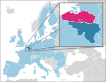
Provinces and cities West Flanders (Bruges) • East Flanders (Ghent) • Antwerp (Antwerp) • Flemish Brabant (Leuven) • Limburg (Hasselt)
See also: Brussels • list of municipalities • Flemish DiamondPolitics History and symbols Flag • Coat of arms • De Vlaamse Leeuw (anthem) • De Leeuw van Vlaanderen (epic) • Day of the Flemish Community (Guldensporenslag)Other Categories:- Former monarchies of Europe
- Former polities in the Netherlands
- States of the Holy Roman Empire
- States and territories established in 862
- States and territories disestablished in 1795
- Flanders
- County of Flanders
- Counts of Flanders
- Burgundian Circle
- Seventeen Provinces
- Former provinces of France


Wikimedia Foundation. 2010.