- Nieuwpoort, Belgium
-
Nieuwpoort Belfry and city hall 
Flag
Coat of armsLocation in Belgium Coordinates: 51°07′N 02°45′E / 51.117°N 2.75°E Country Belgium Region Flemish Region Community Flemish Community Province West Flanders Arrondissement Veurne Government - Mayor Roland Crabbe (CD&V) - Governing party/ies CD&V Area - Total 31.00 km2 (12 sq mi) Population (1 January 2010)[1] - Total 11,267 - Density 363.5/km2 (941.3/sq mi) Postal codes 8620 Area codes 058 Website www.nieuwpoort.be Nieuwpoort is a municipality located in Flanders, one of the three regions of Belgium, and in the Flemish province of West Flanders. The municipality comprises the city of Nieuwpoort proper and the towns of Ramskapelle and Sint-Joris. On January 1, 2008 Nieuwpoort had a total population of 11,062. The total area is 31.00 km² which gives a population density of 350 inhabitants per km². The current mayor of Nieuwpoort is Rolland Crabbe (CD&V)
In Nieuwpoort, the Yser flows into the North Sea. It is also the home of a statue created by Jan Fabre called Searching for Utopia
Contents
History
It obtained city rights in 1163 from Count Philip of Flanders. The Battle of Nieuwpoort, between the Dutch and the Spanish, happened here in 1600. The city was a Dunkirker base.
The city was occupied by French forces for six years between 1757 and 1763, as part of the conditions of the Second Treaty of Versailles between France and Austria.
During the Battle of the Yser, part of the First Battle of Ypres in World War I, Karel Cogge opened the sluice gates on the mouth of the river Yser twice to flood the lower lying land, thus halting the German advance.
Towns
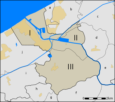
The old city centre of Nieuwpoort is located about three kilometers from the current coastline. Close to the sea, a new tourist centre has developed. Both parts form one contiguous built up area, connected by buildings along the Albert I Laan street and the fishing port. Besides Nieuwpoort proper, two small villages in the Flemish polders are part of the municipality, Sint-Joris and Ramskapelle, Nieuwpoort.
# Name Area Population
1999I Nieuwpoort 10,18 9.437 II Sint-Joris 5,54 259 III Ramskapelle 15,28 555 Nieuwpoort is located by the sea. At the coastal line, it borders the municipalities Koksijde at its town Oostduinkerke and Middelkerke at its town Lombardsijde. Because the territory of the town of Ramskapelle expands far inland, Nieuwpoort has a large number of neighbouring towns, most of which are part of 2 large municipalities:
- a. Lombardsijde (Middelkerke)
- b. Westende (Middelkerke)
- c. Slijpe (Middelkerke)
- d. Mannekensvere (Middelkerke)
- e. Schore (Middelkerke)
- f. Pervijze (Diksmuide)
- g. Veurne
- h. Booitshoeke (Veurne)
- i. Wulpen (Koksijde)
- j. Oostduinkerke (Koksijde)
Map
References
- ^ Population per municipality on 1 January 2010 (XLS; 221 KB)
External links
- Official website - Mainly in Dutch, some info available in French and English
- Startpage of Nieuwpoort - Alle site's binnen Nieuwpoort
- Illustrated Article on Nieupoort & the Yser Front during WW1 at 'Battlefields Europe'
Belgian Coast Tram route Knokke-Heist (Knokke - Heist) - Zeebrugge - Blankenberge - Wenduine - De Haan - Bredene - Ostend - Raversijde - Middelkerke - Westende - Lombardsijde - Nieuwpoort - Oostduinkerke - Koksijde - De PanneBruges Beernem · Blankenberge · Bruges/Brugge · Damme · Jabbeke · Knokke-Heist · Oostkamp · Torhout · Zedelgem · Zuienkerke
Diksmuide Kortrijk Ostend Roeselare Tielt Veurne Ypres Heuvelland · Ieper/Ypres · Langemark-Poelkapelle · Mesen · Poperinge · Vleteren · Wervik · ZonnebekeCategories:- Seaside resorts in Belgium
- Municipalities of West Flanders
- Port cities and towns of the North Sea
- West Flanders geography stubs
Wikimedia Foundation. 2010.


