- Poperinge
Infobox Belgium Municipality
name=Poperinge
picture=
picture-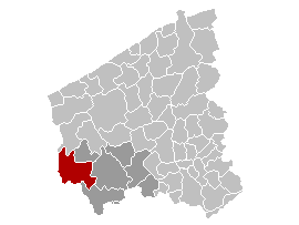
map-
arms=Poperinge wapen.gif
region=BE-REG-FLE
community=BE-NL
province=BE-PROV-WV
arrondissement=Ypres
nis=33021
pyramid-date=
0-19=
20-64=
65=
foreigners=
foreigners-date=
mayor= Christof Dejaegher (CD&V)
majority=CD&V ,VLD
postal-codes=8970, 8972, 8978
telephone-area=057
web= [http://www.poperinge.be/ www.poperinge.be]
lat_deg=50
lat_min=51
lon_deg=02
lon_min=44Poperinge is a
municipality located in the province ofWest Flanders ,Flemish Region ,Belgium . The municipality comprises the city of Poperinge proper and the towns ofKrombeke ,Proven ,Reningelst ,Roesbrugge-Haringe andWatou . OnJanuary 1 2006 , Poperinge had a total population of 19,623. The total area is 119.33 km² which gives apopulation density of 164 inhabitants per km². Poperinge is famous for itshops andlace .The town of Poperinge is situated about 8 miles to the west of
Ieper /Ypres . The region is famous for growing hops. Poperinge is home to the [http://www.poperinge.be/UK/data/nat_hop_museum.htm national hop museum] .Within the town hall courtyard is an execution post.
Poperinge is the birthplace of Dirk Frimout, Belgium's first astronaut.
History
During
World War I , the town was used to billet British troops and also provided a safe area for field hospitals. It was just behind the front line and formed an important link for the British soldiers and their families, especially via the [http://www.greatwar.co.uk/westfront/ypsalient/toch/toch.htm Talbot House] . These help to explain the location of a number of military cemeteries on the outskirts of the town.The charity
Toc H was founded at [http://www.talbothouse.be/en/ Talbot House] in Poperinge.Towns
In addition to the city centre of Poperinge, the municipality also comprises de "
deelgemeente s"Krombeke ,Proven ,Reningelst ,Roesbrugge-Haringe andWatou . The small villages or hamletsAbele andSint-Jan-Ter-Biezen are also located on the territory, but they aren't "deelgemeentes", meaning they weren't independent municipalities before the mergers of municipalities in 70s.Roesbrugge-Haringe actually comprises two separate villages,
Roesbrugge andHaringe . The hamletAbele is located on the border withFrance , and partially lays on French territory.Map
Twin towns
Poperinge is twinned with
*Zatec in theCzech Republic , since1964
*Wolnzach inGermany , since1965
*Hythe, Kent inEngland , since1980
*Rixensart inWalloon Brabant ,Belgium , since1990 External links
* [http://www.poperinge.be Official website ] - Information available in Dutch and limited information available in English, French and German

Wikimedia Foundation. 2010.