- Dinas Powys
-
Coordinates: 51°26′N 3°13′W / 51.43°N 3.22°W
Dinas Powys 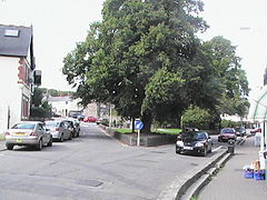
Dinas Powys village centre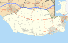
 Dinas Powys
Dinas Powys shown within the Vale of GlamorganOS grid reference ST154716 Principal area Vale of Glamorgan Ceremonial county South Glamorgan Country Wales Sovereign state United Kingdom Post town Dinas Powys Postcode district CF64 Dialling code +44 29 Police South Wales Fire South Wales Ambulance Welsh EU Parliament Wales List of places: UK • Wales • Vale of Glamorgan Dinas Powys (the mordern-day standardised spelling - it was previously also spelt 'Dinas Powis') is a large village and a community in the Vale of Glamorgan in South Wales which takes its name from the Dinas Powys hillfort[1] that dates from the Iron Age. The village is 5.6 miles (9.1 kilometres) south-west of the centre of Cardiff and conveniently situated on the A4055 Cardiff to Barry main road. It is generally regarded as a pleasant dormitory village for Cardiff's commerce and industry commuters since the city has expanded with widespread development around the Cardiff Bay area.
Despite the addition of several housing developments over the past fifty years, the old village centre of Dinas Powys still has a mostly unspoiled and almost rural feel, retaining a large village common and a traditional village centre complete with a post office and a range of small independent shops, public houses, restaurants and community facilities. In addition there are shops, garages, small supermarkets a pharmacy and doctors' surgeries on the main Cardiff Road and a selection of shops on the Murch estate including a post office and a pharmacy.
According to recent electoral rolls the population is in the region of 8,800. This establishes the village as the fifth largest settlement in the Vale of Glamorgan and larger than many chartered towns in the UK. Presently, most people just call it "Dinas", which is pronounced "Dinnis".
Contents
History
The Neolithic and the Middle Ages
See also: Dinas Powys hillfortThe Dinas Powys area has been populated since prehistoric times. The most ancient artifact found in the area is a Neolithic stone age axe-head, discovered by P. W. Brooks in 1949 and now displayed in the National Museum Cardiff.
The village features substantial remains of a Norman castle and the adjacent Cwm George was the site of the celtic hill fort [2] from which the village takes its name. The hill fort site was excavated in the 1950s and was found to contain evidence of major wooden structures and a large quantity of high-status metalwork and jewellery. There was also glass items and imported pottery dating from the sub-Roman period of between the 5th and 7th centuries. The castle was originally the seat of a Norman noble called Baron de Sumeri, but the structure went into decline around 1322 when the de Sumeri male family line came to an end.[3]
According to the historian John Davies, the name Dinas Powys (and its earlier spelling 'Dinas Powis') is derived from the Latin "Dinas Pagus" — meaning "city of pagans". Another theory is that in 1043, it was built by Iestyn ap Gwrgant who, having a spouse called Denis, daughter of Bleddyn ap Cynfyn, Prince of Powys, built a castle in her honour, a few miles to the west of Cardiff, which he called, after her name, Denis Powys. Iestyn was an unpopular ruler being cruel and legend has it that it was because he reneged on his promise of his daughters hand in marriage and dowry of Dinas Powys castle to Einion ap Collwyn for his assistance in battle, that was instrumental in Iestyn's defeat by the Norman Sir Robert Fitzhammond and the subsequent Conquest of Glamorgan.
In the 11th century Dinas Powis was under the control of Sir Reginald de Sully, one of the Twelve Knights of Glamorgan. In 1591, Sir Edward Mansel of Margam wrote his historical document recording The winning of Glamorgan and recorded:
- To Sir Reginald de Sully he (Sir Robert Fitz Haymon) gave the castle and town to be called Sully with the Manor of it, and the Manors of St Andrews and Dinas Powys for his Granary and provisions. This Sir Reginald bestowed much land in fee frankliege to his men and came to be a man of wealth and fame. He had at Sully besides his Castle a fair Manor house built after a new manner, where he did live the most of his time, which house as well as the Castle was broke down by Owain Glendowr[4]
Later in The winning of Glamorgan Mansel records:
- The Lordship of Llantwit is described as so fertile that as Glamorgan was called the Garden of Wales was this Lordship called the Garden of Glamorgan ... and it is the flower of all the Country ... and it was very full of goodly villages and Courtly houses, most of them still in remaining. The Lord had in this Lordship a noble Castle at Dinas Powys and one at Barry, with his Court house of Llantwit and Grange house of Boverton, so that in the whole it is a most Goodly Country.
Dinas Powis was included in the original medieval Welsh political sub-division called the Cantref Brenhinol (The Royal Hundred) which later became the commote known as the Hundred of Dinas Powis, which also encompassed St Andrews Major, Michaelston-le-pit, Westra, Penarth, Cogan, Sully, Lavernock and Llandough.
A sudden expansion
By 1833, the community of Dinas Powys barely existed, but was still larger than nearby Penarth, until Penarth amalgamated with Cogan and Llandough to form a new Town Board. However, St. Andrews Major was at the time substantially larger than Dinas Powis, but even added together their population was still only 474 in total.
The village population had remained almost static at about 300-400 people until the second half of the 19th century when there was an influx into this thriving rural community, including a large contingent from the West Country. The growth of the coal industry saw the first passenger train arrive in Dinas Powys on Sunday, 20 December 1898, and thereafter the population increased rapidly. The new rail link was laid at the bottom end of the Dinas Powys valley and provided a rapid link to the new docks that had been built in Cardiff, Barry and Penarth to handle the expanding coal trade from the South Wales valleys. At that time the only features below St Andrews Major were the small hamlet of Dinas Powis, the rail line, Cadoxton Brook and a number of small farms.
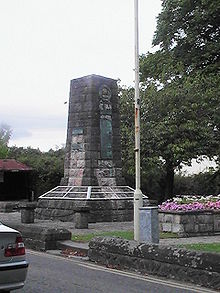 War memorial on the Twyn, Dinas Powys
The new rail link provided far better communication and transport to the area making it a more attractive residential prospect and many workers from Barry and Cardiff moved into the Dinas Powys area. As quickly as 1891, the village population had already more than doubled to 1,149 and by the turn of the century ten years later, had expanded to over 2,000. The village expanded in two ways as from the railway link towards St. Andrew's Major many imposing and fine houses were built, in contrast to the 'railway suburbs' that grew up along the railway, near the current area of Eastbrook, where the new housing was of more modest proportions.[5]
Just a few years after the railway was constructed, the main Cardiff Road was developed over the previous unmetalled trackway that followed the route of the railway line. This provided a further burst of population growth and house building.
In the 20th century
A corner of the village common land was sold to the Barry Docks and Railway Company for the sum of £160. The then Lord of the Manor and ex-military survivor of the First World War, Major General Henry Lee donated an additional sum of £30 and in 1935 the combined fund was used to upgrade the small green in the centre of the village, known locally as the Twyn, with a War Memorial.[6]
Governance
Uniquely for this part of Wales, the village is notable for having a community council that has been dominated by the Welsh nationalist party Plaid Cymru, for over two decades. In the most recent (May 2008) elections, this dominance was reduced slightly, as the Conservative Party won four additional seats on the Community Council, all at the expense of Plaid Cymru, including the defeat of Chris Franks AM.
Dinas Powys falls within the Vale of Glamorgan parliamentary constituency and is currently represented by Alun Cairns MP, a member of the Conservative Party.
Jane Hutt, a resident of Barry, represents the Vale of Glamorgan in the National Assembly for Wales (Labour Party).
Ward representatives to the Vale of Glamorgan Council are: Val Hartrey, Keith Hatton, Margaret Randall and Chris Williams - all are members of Plaid Cymru.
Geography
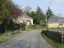 The Westra, Dinas Powys
Dinas Powys village is spread across the full width of a traditional wooded valley, with the Cadoxton River running in the river valley.
The surrounding soils within the village bounds are mostly a strong, brown, dry earth, well adapted for arable farming and the growing of grains of all kinds that contributed to the area being a mostly farming community until the modern era. The substratum under the whole area is a limestone that was likely laid down under a warm ocean at some stage in the distant past.
The village has not been able to spread northwards, because there were (and still are) golf courses and protected woodlands between the village and Michaelston-le-pit. The freeholders of Cwrt-yr-Ala Estate prevented the two from merging. More recent housing development has taken place in a linear fashion either side of the main Cardiff road and in the direction of Cadoxton and Barry.
It is obvious by comparing variously aged maps that over the last hundred years Penarth and Dinas Powys have spread and grown closer together. In many places the two communities are only separated by a few hundred yards and a couple of fields, although no direct road connections have been added entailing a roundabout car route of several miles via Llandough. The only existing direct road is the medieval and winding single track 'Cross Common Road'. Another traditional lane crossing that existed between the current site of The Castle Oak pub and the current Erw Delyn school at Redlands Heights, Penarth was closed to through traffic following extensions to the Murch estate in the 1970s.
According to the Environment Agency, in the October floods of 1998 only six properties at Dinas Powys were affected. Flooding was caused by the floodwater overtopping the banks of the Cadoxton River among others and ordinary watercourses, restrictions to flow in channels and surcharging of drains.[7]
Demography
The United Kingdom Census 2001 records the population as being 8,512. Electoral roll information since that date indicates the village population is now closer to 8,800.
Economy
There are little in the way of major employers in the village. The majority of the working population commute to Cardiff, Penarth and Barry.
Landmarks
- Dinas Powis village Common
- Dinas Powis Castle
- Cwm George and Cwrt-yr-Ala Woodlands
- War memorial on the village green
Education
Dinas Powys technically has no secondary school of its own but currently remains home to one half of Penarth’s St Cyres Comprehensive School. The "Dinas Site" is the smaller of the two existing facilities and contains the locally living lower school students from year seven to year nine, representing ages 11 to 14, while upper school for the older children is located on Redlands Heights in Penarth.
However, the St Cyres lower school in the village is currently scheduled for closure in 2010 - 2011, to be replaced by a larger single site located in Penarth. This is subject to finance being available in the coming years.
The village also has three other schools - Dinas Powys Infant school, Murch Junior School and St Andrews Major Church in Wales Primary school.
Religious Sites
St. Peter's church on Mill Road is the main Church in Wales parish church within the village while the Roman Catholic congregation worships at St. Mary's church on Edith Road.
Dinas Powys is also noted for its 14th century Norman parish church, dedicated to St Andrew. The building is located in the hamlet of St Andrews, just under a mile away from the Dinas Powys village centre.
Additionally there is the nearby church of St Michael and All Angels in Michaelston-le-Pit.
There are also two Methodist chapels within the village, one is a small "tin Tabercacle" in the Eastbrook area, at the top of Chapel close, opposite Eastbrook Railway station; the larger Methodist Church backs on to Station Road where, until May 2008 its front entrance was, the entrance has now been relocated to the access off Mount Road, on the edge of the common.. Dinas Powys Baptist Church is on Murch Crescent, and Bethesda Chapel is on Fairoaks.
Sports and Recreation
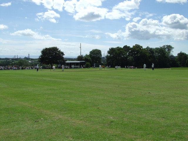
 Cricket on the Common, Dinas Powys
The extensive recreation area at the village Common, administered by Dinas Powys Community Council, is home to several established sports teams. The first Rugby Football was played on the Common at Dinas Powys, in 1882. It is said that a group of young farm workers challenged a group of players at the new Gwalia Brickworks and thus history was made.
Organised sports are also played on Parc Bryn-a-don and the Murch Playing Fields within the village.
Dinas Powys Football Club became the first in the Vale of Glamorgan to achieve the Club Accreditation Programme Bronze Award set by the Football Association of Wales Trust Technical Department.
The Dinas Powys Rugby Club located on the common, also caters for several skittles teams
Dinas Powys Golf Club was founded in 1914 and is considered to be one of the finest courses in Wales, with views over the city of Cardiff and Cardiff Bay. The tennis club and coaching is also considered one of the finest in the Vale of Glamorgan.
There has been an active branch of the Pony Club in the village since 1975.
Dinas Powys Cricket Club were established in 1882. They field a 1st and 2nd XI side in the Welsh Club Cricket Conference, playing their home league matches at Parc Bryn y Don, and also run a Midweek League side and a Sunday friendly side, playing home matches on the spiritual home of the club, Dinas Powys Common. The club also has a healthy junior section, running sides at Under 9, Under 11, Under 13 and Under 15
Public services and village facilities
The village has two railway stations, one at either end of the village with Eastbrook station at the Cardiff end and Dinas Powys station at the Barry end. Both stations are on the same Vale of Glamorgan railway line operated by Arriva Trains Wales. Monday to Saturday daytimes there is a fifteen minute frequency northbound to Cardiff Central and beyond. Southbound three trains per hour to Barry Island, plus an hourly service to Bridgend via Rhoose.
There are many voluntary organizations active within the village and available for the active participation of residents, including a large Scout group.
Several pubs serve the village, mostly in the village centre, and include The Star, The Cross Keys, and The Three Horse Shoes. 'The Swan' in Eastbrook closed permanently in 2007. Across the other side of the railway lines is The Castle Oak (until 2006 known as The Malthouse) located on the Murch estate near a small parade of shops.
Notable people
- John Smith - Former Member of Parliament (Labour Party) lives in the village
- Ray Smith (1936–1991) - The versatile Welsh actor who most famously played Chief Superintendent Gordon Spikings in TV's Dempsey & Makepeace lived in the village and was a regular at The Malthouse pub until his death
- Huw Justin Smith (1965–2007) Son of Ray Smith and better known as Pepsi Tate, bass guitarist of Welsh Glam Metal band Tigertailz who made the UK top 40 album charts in the early 1990s. He later He pursued a career in television as a producer and director. His work for BBC Wales included directing the weekly politics programme, Dragon's Eye, presented by former BBC Wales political editor David Williams
- Dave Edmunds (born 15 April 1944 in Cardiff) - the successful Welsh recording artist, popular singer, rock guitarist and high profile record producer lived near the Common in Dinas Powys with his family during the 1970s and early 1980s
- Sarah Loosemore (born 15 June 1971 in Cardiff) - tennis player, at 17 the youngest British woman to play at the Wimbledon championships, raised in the village
- Donna Edwards (born in Merthyr Tydfil)- double BAFTA winning actress, who starred in Belonging, who continues to appear in Pobol y Cym, and who appeared in BAFTA winning series Gavin and Stacey lives in Dinas Powys
- Sophie Borja - actress, who played Roxy in BBC's Tracy Beaker series, lives in Dinas Powys
- Lucy Borja - actress, who played Chloe in BBC's Young Dracula series, lives in Dinas Powys
- Cameron Jerome - Current Birmingham City footballer lived in Dinas Powys when he was first signed by Cardiff City
- Noel Johnson - 1916 -1999 the radio voice of Dick Barton special agent on the BBC resided in the village and was a regular in the Three Horse Shoes and Cross Keys Public Houses
- Jeremy Colman - former Auditor General for Wales, lives in the village
- Charlotte Church - Singer and TV chat show host moved to the village in July 2010 [8]
References
External links
Categories:- Hill forts in Wales
- Sub-Roman Britain
- Villages in the Vale of Glamorgan
- Archaeological sites in the Vale of Glamorgan


Wikimedia Foundation. 2010.