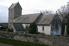
Marcross

Marcross
Marcross Church

Marcross (Welsh: Marcroes) is a small village and civil parish in the Vale of Glamorgan, south Wales. It consists of a public house (the Horseshoes Inn) and a few scattered houses, farms, and a small medieval church in the centre of the village.

History

The cove to the south of the village has two lighthouses, one early 19th century and another from the mid-20th century. The cove is said to have been a looting station for pirates in the 18th century.

Coordinates: 51°25′N 3°33′W / 51.417°N 3.55°W / 51.417; -3.55


Wikimedia Foundation. 2010.

Игры ⚽ Нужно решить контрольную?

Look at other dictionaries:

  • Wick, Vale of Glamorgan — infobox UK place country = Wales welsh name= Y Wig constituency welsh assembly= latitude= 51.4376 longitude= 3.5508 map type= United Kingdom official name= Wick unitary wales= Vale of Glamorgan lieutenancy wales= South Glamorgan constituency… …   Wikipedia

  • Vale of Glamorgan — For other uses, see Vale of Glamorgan (disambiguation). Vale of Glamorgan County Borough Bwrdeistref Sirol Bro Morgannwg Geography Area …   Wikipedia

  • Cowbridge — Coordinates: 51°27′38″N 3°26′53″W / 51.4605°N 3.4480°W / 51.4605; 3.4480 …   Wikipedia

  • Ogmore, Vale of Glamorgan — For other places, see Ogmore (disambiguation). Ogmore (Welsh: Ogwr) is a village in the Vale of Glamorgan, Wales on the River Ogmore. It grew around the now ruined Ogmore Castle, built by the Normans. The village does not lie in the parliamentary …   Wikipedia

  • Cosmeston Medieval Village — is a living history medieval village near Lavernock in the Vale of Glamorgan not far from Penarth and Cardiff in south Wales. Based upon remains discovered during a 1980s archaeological dig in the grounds of Cosmeston Lakes Cou …   Wikipedia

  • Colwinston — Coordinates: 51°28′07″N 3°31′34″W / 51.46853°N 3.52599°W / 51.46853; 3.52599 …   Wikipedia

  • Ogmore-by-Sea — For other places, see Ogmore (disambiguation). Coordinates: 51°27′52″N 3°38′07″W / 51.46435°N 3.63526°W / 51.46435; 3.63526 …   Wikipedia

  • Dinas Powys — Coordinates: 51°26′N 3°13′W / 51.43°N 3.22°W / 51.43; 3.22 …   Wikipedia

  • Corntown — Coordinates: 51°29′06″N 3°33′41″W / 51.4849°N 3.5615°W / 51.4849; 3.5615 …   Wikipedia

  • Colcot —   District of Barry   The A4050 road, Port Road East section viewed from Colcot …   Wikipedia

Share the article and excerpts

Direct link
Do a right-click on the link above
and select “Copy Link”