- Moulton, Vale of Glamorgan
-
Coordinates: 51°25′20″N 3°20′03″W / 51.422222°N 3.334167°W
Moulton 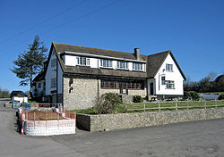
The Three Horse Shoes Pub, Moulton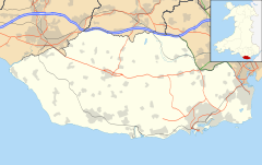
 Moulton
Moulton shown within the Vale of GlamorganPrincipal area Vale of Glamorgan Ceremonial county South Glamorgan Country Wales Sovereign state United Kingdom Post town Barry Postcode district CF62 Police South Wales Fire South Wales Ambulance Welsh EU Parliament Wales UK Parliament Vale of Glamorgan Welsh Assembly Vale of Glamorgan List of places: UK • Wales • Vale of Glamorgan Moulton is a hamlet in the Vale of Glamorgan, southeastern Wales. It lies off the A4226 road on the road, northwest of Barry and east of Llancarfan. The landmark of note is the Three Horse Shoes pub and restaurant[1] which attracts visitors from all across the Vale of Glamorgan. To the south of Moulton is the small hamlet of Sutton.
References
- ^ McGill, Angus (1969). Pub: a celebration. Longmans. http://books.google.com/books?id=3SITAQAAIAAJ. Retrieved 28 January 2011.
Categories:- Villages in the Vale of Glamorgan
- Glamorgan geography stubs


Wikimedia Foundation. 2010.