Porthkerry Park

Porthkerry Park

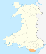
Coordinates: 51°23′38″N 3°18′49″W / 51.3939°N 3.3136°W / 51.3939; -3.3136

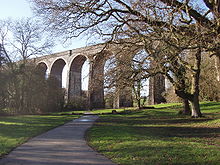
The viaduct at Porthkerry Park near Cardiff International Airport, Barry, Wales
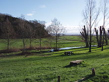
View across the park's main field, towards the pebble beach and the Bristol Channel.

Porthkerry Park is a large, public country park on the coast of Barry in the Vale of Glamorgan in south Wales. It has fields, extensive woodland and nature trails, cliff-top pathways, a pebble-stone beach, and a small golf course. Architecturally, it is noted for its prominent viaduct crossed by a railway that served as a transportation for coal from the South Wales Valleys to the port in the 19th and 20th centuries. With the combination of green areas and the coastal location, the park is a popular destination for local primary schools taking their pupils on trips to study nature. The Egerton Grey Country House Hotel is also located in Porthkerry.

Contents

History

On the northern side of the park is the site of the old village at Cwmcidi (meaning Valley of the Black Dog), which came into existence before the middle of the 13th century. In 1622, Cwmcidi contained 5 houses bordering "Comkedye Street", interspersed with a number of tofts (dwelling sites) plus three scattered dwellings. By 1812, there remained only three cottages and a farmhouse. The cottages were finally swept away in the 1840s when the area was landscaped by the Romilly family to form Porthkerry Park. The name - although slightly anglicised - lives on in the area, in the form of a nearby public house, The Cwm Ciddy.

Geography

Porthkerry Park lies on the Welsh coast, alongside the Bristol Channel. Further up the shore, Barry Island is accessible via the pebble beach. On a clear day, it is possible to walk from Porthkerry to Cold Knap (and vice versa) in a mere matter of minutes.

Porthkerry Park with view of the Porthkerry viaduct

Maintenance

The park is maintained by two rangers,one of whom has a residence at a quaint, old cottage along the main park road.

External links


Wikimedia Foundation. 2010.

Игры ⚽ Нужна курсовая?

Look at other dictionaries:

  • Barry Island Pleasure Park — Infobox Amusement park name = Barry Island Pleasure Park image size = 100px location = flagicon|Wales Barry Island, Wales location2 = address = Barry Island Pleasure Park, Barry Island, Barry, Vale of Glamorgan, CF62 5TH, Wales opening date =… …   Wikipedia

  • Cosmeston Lakes Country Park — Cosmeston Lake from the East Location Penarth, Vale of Glamorgan, U.K. Coordinates …   Wikipedia

  • Barry, Vale of Glamorgan — Infobox UK place country = Wales welsh name = Y Barri official name = Barry| latitude = 51.4064 longitude = 3.2667 static static image caption = Barry Council Office and Library, King s Square, in the town centre unitary wales = Vale of Glamorgan …   Wikipedia

  • Vale of Glamorgan — For other uses, see Vale of Glamorgan (disambiguation). Vale of Glamorgan County Borough Bwrdeistref Sirol Bro Morgannwg Geography Area …   Wikipedia

  • Cosmeston Medieval Village — is a living history medieval village near Lavernock in the Vale of Glamorgan not far from Penarth and Cardiff in south Wales. Based upon remains discovered during a 1980s archaeological dig in the grounds of Cosmeston Lakes Cou …   Wikipedia

  • Coedarhydyglyn — South Lodge and drive of Coedarhydyglyn Park …   Wikipedia

  • Cardiff Airport — Maes Awyr Caerdydd IATA …   Wikipedia

  • Merthyr Dyfan —   District of Barry and parish/ward   Merthyr Dyfan parish church …   Wikipedia

  • Ogmore-by-Sea — For other places, see Ogmore (disambiguation). Coordinates: 51°27′52″N 3°38′07″W / 51.46435°N 3.63526°W / 51.46435; 3.63526 …   Wikipedia

  • Colcot —   District of Barry   The A4050 road, Port Road East section viewed from Colcot …   Wikipedia

Share the article and excerpts

Direct link
Do a right-click on the link above
and select “Copy Link”