- Dalmarnock
-
Coordinates: 55°50′25″N 4°13′11″W / 55.840161°N 4.219675°W
Dalmarnock Scottish Gaelic: Dail Mheàrnaig 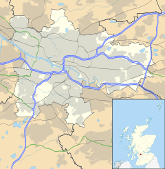
 Dalmarnock
Dalmarnock shown within GlasgowOS grid reference NS611630 Council area Glasgow City Council Lieutenancy area Glasgow Country Scotland Sovereign state United Kingdom Post town GLASGOW Postcode district G40 Dialling code 0141 Police Strathclyde Fire Strathclyde Ambulance Scottish EU Parliament Scotland UK Parliament Glasgow Central Scottish Parliament Glasgow Shettleston Glasgow List of places: UK • Scotland • Glasgow Dalmarnock (Scottish Gaelic: Dail Mheàrnaig) is a district in the Scottish city of Glasgow. It is situated north of the River Clyde. It is bounded by the Clyde to the south and east, Parkhead to the north, and Bridgeton at Dunn Street to the north west. The area covers part of a loop in the River Clyde called the Cuningar Loop (known locally as 'The Vallies').
Contents
Bridge
There is a bridge over the River Clyde on Dalmarnock Road called Dalmarnock Bridge. The first bridge in the area was a wooden one erected in 1821 to connect Rutherglen and Dalmarnock. It was replaced by a new timber bridge in 1841 and in 1891 by the current Dalmarnock Bridge, designed by the engineers Crouch & Hogg.
History
The area was once heavily industrialised. Sir William Arrol & Co. had its extensive engineering works at Dunn Street and Baltic Street from 1873. From its beginnings in boiler making, the firm later became renowned for its achievements in the field of Structural engineering. Amongst the many bridges constructed throughout Britain were the Forth Railway Bridge and Forth Road Bridge, the Humber Bridge and London's Tower Bridge. The company was eventually taken over by Clarke Chapman in 1969 and the Dalmarnock Works closed in 1986. There was also a large coal fired power station located near Dalmarnock Bridge. It was built by Glasgow Corporation in two stages, with phase one opening in 1920 and phase two in 1926. It was closed in 1977 by the South of Scotland Electricity Board.
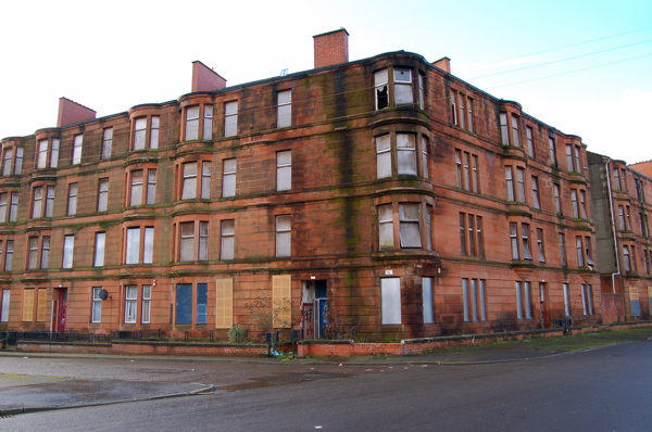
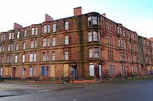 Victorian sandstone tenements in Ardenlea Street, Dalmarnock that were originally renovated as part of the GEAR (Glasgow East Area Renewal) scheme in the late 1970s, have seen their residents systematically rehoused in recent years, thus being allowed to fall into a dilapidated state once more. They are now planned to be totally demolished as part of the 2014 Commonwealth Games athletes village masterplan by RMJM.
The east side of Summerfield Street was bombed during the Second World War. Most of the Victorian red-sandstone tenements on Dalmarnock Road and Springfield Road were demolished in the '60s and early '70s, although some were renovated. Springfield Road remains the centre of the community, with several retailers and small businesses. In the 1960s, a new housing scheme was built, consisting of four twenty-two storey tower blocks and 'H-block' maisionettes. Two of the towers, 40 & 50 Millerfield Road, were demolished in 2002. One other tower was demolished on 1 July 2007, and the final one on 9 September 2007.
Dalmarnock now, August 2011, has no housing on Ardenlea St / Sunnybank St side of the area, due to the construction in the area pertaining to the Commonwealth Games and City Legacy.
There are no retailers left at all in the area apart from a small shop, that was setup by the workers in the Community Centre, and a small shop setup by one of the locals in the area. These have been a welcome sight for the area residents as the nearest shops are either Bridgeton, the Tesco on Dalmarnock Road or The Forge in Parkhead. There is still the petrol station on Dalmarnock Road and the Car Wash. There is also a lot of small business units in the Nuneaton Street area and Calder Millerfield which supplies meat based products to the fast food markets, which is also on Nuneaton Street.
Rail
Dalmarnock railway station, on the Argyle Line, serves the local area.
Dalmarnock Train Station will be getting a overhaul due to the Commonwealth Games.Dalmarnock Station Overhaul .
Education
The area used to have four schools: Springfield Road Primary, Springfield Primary, Riverside Secondary and Our Lady of Fatima RC Primary School on Springfield Road have now closed. There is a Dalmarnock Primary School, however, it is situated, unlike the name suggests, in the Bridgeton area of the East End of Glasgow and should not be counted in the schools list for the area.
Commonwealth Games
Dalmarnock is the proposed location for the athletes' village when Glasgow hosts the 2014 Commonwealth Games[1] and proposed skyscraper East One.
The Sir Chris Hoy Velodrome is also in the area, at the section of Springfield Road where it intersects London Road.
Notable people
- Professional footballer Kenny Dalglish who played for Celtic F.C. and Liverpool was born in Dalmarnock.
- George Chisholm, trombonist, was born in Dalmarnock.
- Glasvegas
References
Categories:- Districts of Glasgow
- Glasgow geography stubs

Wikimedia Foundation. 2010.