- Crookston, Glasgow
-
Coordinates: 55°50′34″N 4°22′06″W / 55.842780°N 4.368377°W
Crookston Scottish Gaelic: Baile Chròc
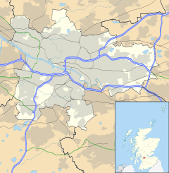
 Crookston shown within Glasgow
OS grid reference NS518636 Council area Glasgow City Council Lieutenancy area Glasgow Country Scotland Sovereign state United Kingdom Post town GLASGOW Postcode district G52 Dialling code 0141 Police Strathclyde Fire Strathclyde Ambulance Scottish EU Parliament Scotland UK Parliament Glasgow South West Scottish Parliament Glasgow Pollok Glasgow List of places: UK • Scotland • Glasgow Crookston (Baile Cruic in Scottish Gaelic) is a residential suburb on the southwestern edge of the city of Glasgow, Scotland.
Formerly a village in its own right, Crookston (Crocis toune) and its surrounding lands and castle (Dùn Cruic in Scottish Gaelic), were named after the feudal Norman lord, Robert Croc, who was gifted the Levern valley in Renfrewshire by King David I of Scotland in 1170.
In the 1920s, Crookston, together with neighbouring Cardonald, Hillington and Halfway, was annexed by the expanding city of Glasgow. Crookston now lies just within Glasgow's present-day boundary with Ralston, Renfrewshire.
See also
Categories:- Districts of Glasgow
- Glasgow geography stubs
Wikimedia Foundation. 2010.

