- National Register of Historic Places listings in Waukesha County, Wisconsin
-
Buildings, sites, structures, districts, and objects in Waukesha County listed on the National Register of Historic Places
-
- This National Park Service list is complete through NPS recent listings posted November 10, 2011.[1]
This document is intended to provide a comprehensive listing of entries in the National Register of Historic Places that are located in Waukesha County, Wisconsin. The locations of National Register properties, the latitude and longitude coordinates of which are included below, may be seen in a Google map.[2]
Current listings
[3] Landmark name [4] Image Date listed Location City or town Summary 1 Sewall Andrews House July 7, 1981 103 Main St.
42°51′42″N 88°19′57″W / 42.86167°N 88.3325°WMukwonago 2 Arcadian Bottling Works October 28, 1983 900 N. Hartwell Ave.
43°0′44″N 88°13′20″W / 43.01222°N 88.22222°WWaukesha 3 Arlington Apartments January 21, 1987 309 Arlington St.
43°0′23″N 88°13′55″W / 43.00639°N 88.23194°WWaukesha 4 Albert R. Baer House September 21, 1988 W166 N8990 Grand Ave.
43°10′52″N 88°6′57″W / 43.18111°N 88.11583°WMenomonee Falls 5 Ralph C. Bailie House December 8, 1986 530 North Ave.
43°6′39″N 88°20′40″W / 43.11083°N 88.34444°WHartland 6 Bank of Hartland April 21, 1988 112 E. Capitol Dr.
43°6′17″N 88°20′49″W / 43.10472°N 88.34694°WHartland 7 Barfoth-Blood Mound Group (47 WK 63) September 2, 1982 Address Restricted Mukwonago 8 Andrew Barnes House September 21, 1988 N89 W16840 Appleton Ave.
43°10′51″N 88°7′7″W / 43.18083°N 88.11861°WMenomonee Falls 9 Barney House October 28, 1994 W264 S3641 Saylesville Rd.
42°58′42″N 88°16′34″W / 42.97833°N 88.27611°WWaukesha 10 Everett P. Barrett House February 24, 1995 120 S. Porter Ave.
43°0′9″N 88°12′43″W / 43.0025°N 88.21194°WWaukesha 11 Beaumont Hop House November 23, 1977 Address Restricted Hartland 12 Becker and Schafer Store Building June 2, 1995 1002-1004 White Rock Ave.
43°0′48″N 88°13′33″W / 43.01333°N 88.22583°WWaukesha 13 Big Bend Mound Group No. 2 December 19, 1978 S of Big Bend Big Bend 14 Bishopstead March 1, 1984 153 W. Oakwood Dr.
43°4′23″N 88°25′6″W / 43.07306°N 88.41833°WDelafield 15 Sen. William Blair House October 28, 1983 434 Madison St.
43°0′50″N 88°14′12″W / 43.01389°N 88.23667°WWaukesha 16 Block C Historic District January 11, 1996 Roughly bounded by W. Main St., Gaspar St. and Broadway
43°0′41″N 88°13′51″W / 43.01139°N 88.23083°WWaukesha 17 J. C. Booth House January 25, 1973 About 1 mi. SW of Saylesville on Saylesville Rd.
42°56′22″N 88°20′20″W / 42.93944°N 88.33889°WSaylesville 18 Patrick J. Buckley House February 28, 1991 1101 Buckley St.
43°0′51″N 88°13′36″W / 43.01417°N 88.22667°WWaukesha 19 Burr Oak Tavern December 28, 1988 315-317 E. Capitol Dr.
43°6′17″N 88°20′33″W / 43.10472°N 88.3425°WHartland 20 Thomas Camp Farmhouse September 21, 1988 W204 N8151 Lannon Rd.
43°9′56″N 88°9′49″W / 43.16556°N 88.16361°WMenomonee Falls 21 Caples' Park Historic District March 17, 1988 Roughly bounded by E. Newhall Ave., S. Hartwell Ave., Windsor Dr. and Oxford Rd., and S. East Ave.
42°59′54″N 88°13′27″W / 42.99833°N 88.22417°WWaukesha 22 Dr. Alfred L. Castleman House August 2, 1996 975 S. Waterville Rd.
43°1′20″N 88°26′16″W / 43.02222°N 88.43778°WSummit 23 Walter S. Chandler House December 27, 1974 151 W. College Ave.
43°0′10″N 88°13′44″W / 43.00278°N 88.22889°WWaukesha 24 Chapel of St. Mary the Virgin February 23, 1972 2 mi. SW of Nashotah on Nashotah House Rd.
43°4′57″N 88°25′34″W / 43.0825°N 88.42611°WNashotah 25 Chicago and Northwestern Railroad Passenger Depot February 24, 1995 319 Williams St.
43°0′20″N 88°13′57″W / 43.00556°N 88.2325°WWaukesha 26 George Lawrence Jr. Clarke House February 24, 1995 12810 W. Hampton Ave.
43°6′19″N 88°4′21″W / 43.10528°N 88.0725°WButler 27 George N. Cobb House March 2, 1982 S of Oconomowoc at 1505 N. Golden Lake Rd.
43°3′3″N 88°31′24″W / 43.05083°N 88.52333°WOconomowoc 28 College Avenue Historic District October 28, 1983 Fountain St., S. East and College Aves.
43°0′11″N 88°13′42″W / 43.00306°N 88.22833°WWaukesha 29 Alexander Cook House October 28, 1983 600 E. North St.
43°0′55″N 88°14′2″W / 43.01528°N 88.23389°WWaukesha 30 Cutler Mound Group November 3, 1988 Address Restricted Waukesha 31 Morris Cutler House October 28, 1983 401 Central Ave.
43°0′13″N 88°14′3″W / 43.00361°N 88.23417°WWaukesha 32 Dansk Evangelical Lutheran Kirke April 21, 1988 400 W. Capitol Dr.
43°6′9″N 88°21′10″W / 43.1025°N 88.35278°WHartland 33 Cyrus Davis Farmstead March 15, 1989 W204 N7776 Lannon Rd.
43°9′29″N 88°9′41″W / 43.15806°N 88.16139°WMenomonee Falls 34 Cyrus Davis-Davis Brothers Farmhouse September 21, 1988 W204 N7818 Lannon Rd.
43°9′35″N 88°9′45″W / 43.15972°N 88.1625°WMenomonee Falls 35 Delafield Fish Hatchery May 13, 1981 Main St.
43°3′40″N 88°24′26″W / 43.06111°N 88.40722°WDelafield 36 Dewey Mound Group December 19, 1978 Address Restricted Big Bend 37 Dousman Inn January 15, 1979 15670 Blue Mound Rd.
43°2′10″N 88°6′27″W / 43.03611°N 88.1075°WBrookfield 38 Downtown Historic District October 28, 1983 Roughly bounded by Broadway, Grand Ave., Clinton and South Sts.
43°0′40″N 88°13′55″W / 43.01111°N 88.23194°WWaukesha 39 George Dwinnell House October 28, 1983 442 W. College Ave.
43°0′11″N 88°14′10″W / 43.00306°N 88.23611°WWaukesha 40 East Broadway Historic District March 7, 1996 Roughly, Broadway from Fisk Ave. to Morningside Dr.
43°0′16″N 88°12′42″W / 43.00444°N 88.21167°WWaukesha 41 East Capitol Drive Historic District September 11, 1986 337-702 E. Capitol Dr.
43°6′18″N 88°20′17″W / 43.105°N 88.33806°WHartland 42 Dr. F. C. Elliot House October 28, 1983 501Dunbar Ave.
43°0′20″N 88°14′13″W / 43.00556°N 88.23694°WWaukesha 43 Joseph Fabacker House February 24, 1995 341 NW. Barstow St.
43°1′0″N 88°14′2″W / 43.016667°N 88.23389°WWaukesha 44 First Baptist Church October 28, 1983 247 Wisconsin Ave.
43°0′34″N 88°13′52″W / 43.00944°N 88.23111°WWaukesha 45 First Congregational Church December 8, 1986 214 E. Capitol Dr.
43°6′18″N 88°20′36″W / 43.105°N 88.34333°WHartland 46 First Congregational Church January 30, 1992 100 E. Broadway
43°0′24″N 88°13′17″W / 43.00667°N 88.22139°WWaukesha 47 First German Reformed Church September 13, 1991 413 Wisconsin Ave.
43°0′34″N 88°14′6″W / 43.00944°N 88.235°WWaukesha 48 First Methodist Church December 1, 1983 121 Wisconsin Ave.
43°0′34″N 88°12′56″W / 43.00944°N 88.21556°WWaukesha 49 Andrew Frame House October 28, 1983 507 N. Grand Ave.
43°0′29″N 88°13′52″W / 43.00806°N 88.23111°WWaukesha 50 Freewill Baptist Church June 22, 1998 19750 W. National Ave.
42°56′40″N 88°9′37″W / 42.94444°N 88.16028°WNew Berlin 51 Genesee Town Hall June 25, 1981 Genesee St.
42°58′1″N 88°22′23″W / 42.96694°N 88.37306°WGenesee Depot 52 Goodwin-McBean Site (47 WK 184) September 17, 1982 Address Restricted Big Bend 53 Perry Grace House October 28, 1983 307 N. West Ave.
43°0′23″N 88°14′11″W / 43.00639°N 88.23639°WWaukesha 54 Grand View Health Resort January 31, 1984 500 Riverview Ave.
43°1′17″N 88°13′59″W / 43.02139°N 88.23306°WWaukesha 55 Gredler-Gramins House November 24, 1980 20190 Davidson Rd.
42°59′20″N 88°9′47″W / 42.98889°N 88.16306°WBrookfield 56 Hadfield Company Lime Kilns March 12, 1982 N of Waukesha
43°2′19″N 88°12′53″W / 43.03861°N 88.21472°WWaukesha 57 Hartland Railroad Depot April 21, 1988 301 Pawling Ave.
43°6′1″N 88°20′57″W / 43.10028°N 88.34917°WHartland 58 Haseltine Cobblestone House January 15, 1980 N of Big Bend on Big Bend Dr.
42°53′38″N 88°12′34″W / 42.89389°N 88.20944°WBig Bend 59 Hawks Inn 
February 23, 1972 428 Wells St.
43°3′35″N 88°24′25″W / 43.05972°N 88.40694°WDelafield 1846 60 David J. Hemlock House December 1, 1983 234 Carroll St.
43°0′29″N 88°13′51″W / 43.00806°N 88.23083°WWaukesha 61 LeRoy A. Henze House September 21, 1988 N89 W15781 Main St.
43°10′43″N 88°6′23″W / 43.17861°N 88.10639°WMenomonee Falls 62 Ahira R. Hinkley House January 21, 1974 NE of Eagle off WI 59
42°54′4″N 88°27′8″W / 42.90111°N 88.45222°WEagle 63 Herbert Hoeltz House September 21, 1988 N87 W15714 Kenwood Blvd.
43°10′39″N 88°6′19″W / 43.1775°N 88.10528°WMenomonee Falls 64 Elizabeth Hoos House September 21, 1988 W164 N9010 Water St.
43°10′54″N 88°6′47″W / 43.18167°N 88.11306°WMenomonee Falls 65 Hoos-Rowell House September 21, 1988 W164 N8953 Water St.
43°10′50″N 88°6′49″W / 43.18056°N 88.11361°WMenomonee Falls 66 Harold Hornburg House December 8, 1986 213 Warren Ave.
43°6′12″N 88°20′38″W / 43.10333°N 88.34389°WHartland 67 John Howitt House October 28, 1983 407 N. Grand Ave.
43°0′24.48″N 88°13′52.68″W / 43.0068°N 88.2313°WWaukesha 68 Jackson House December 8, 1986 235 North Ave.
43°6′27″N 88°20′47″W / 43.1075°N 88.34639°WHartland 69 Samuel D. James House October 24, 1996 726 N. East Ave.
43°0′38″N 88°13′38″W / 43.01056°N 88.22722°WWaukesha 70 William Johnston Lime Kiln March 12, 1982 E of Genesse Depot
42°57′58″N 88°19′17″W / 42.96611°N 88.32139°WSaylesville 71 Robert O. Jones House October 28, 1983 501 W. College Ave.
43°0′9″N 88°14′13″W / 43.0025°N 88.23694°WWaukesha 72 Frank Koehler House and Office September 21, 1988 N88 W16623 Appleton Ave.
43°10′40″N 88°6′58″W / 43.17778°N 88.11611°WMenomonee Falls 73 Koepsell House October 25, 1973 Old World Wisconsin, off WI 59
42°51′44″N 88°29′15.52″W / 42.86222°N 88.4876444°WEagle 74 Laflin Avenue Historic District October 28, 1983 W. Laflin and Garfield Aves.
43°0′3″N 88°13′46″W / 43.00083°N 88.22944°WWaukesha 75 Lain-Estburg House December 27, 1974 229 Wisconsin Ave.
43°0′35″N 88°13′48″W / 43.00972°N 88.23°WWaukesha 76 Garwin A. Mace House September 21, 1988 W166 N8941 Grand Ave.
43°10′49″N 88°6′59″W / 43.18028°N 88.11639°WMenomonee Falls 77 Garwin Mace Lime Kilns March 12, 1982 LimeKiln Park
43°10′38″N 88°6′47″W / 43.17722°N 88.11306°WMenomonee Falls 78 Madison Street Historic District March 22, 1990 Jct. of Madison, Randall, and Third Sts.
43°0′50″N 88°14′13″W / 43.01389°N 88.23694°WWaukesha 79 Main Street Historic District September 21, 1988 Main and Appleton Sts.
43°10′46″N 88°6′47″W / 43.17944°N 88.11306°WMenomonee Falls 80 William G. Mann House October 28, 1983 346 Maple Ave.
43°0′25″N 88°14′4″W / 43.00694°N 88.23444°WWaukesha 81 McCall Street Historic District December 1, 1983 and March 29, 1993 McCall and James Sts., and N. East and Hartwell Aves. (original)
Roughly, Charles and James Sts. from College Ave. to McCall St. and Hartwell Ave. from College to Grove St. (increase)
43°0′19″N 88°13′26″W / 43.00528°N 88.22389°WWaukesha 82 Menomonee Falls City Hall September 21, 1988 N88 W16631 Appleton Ave.
43°10′40″N 88°7′0″W / 43.17778°N 88.116667°WMenomonee Falls 83 Menomonee Golf Club September 21, 1988 N73 W13430 Appleton Ave.
43°9′3″N 88°4′36″W / 43.15083°N 88.07667°WMenomonee Falls 84 Charles Merten House March 17, 1995 929 Rosemary St.
43°0′48″N 88°13′8″W / 43.01333°N 88.21889°WWaukesha 85 Miller-Davidson House April 24, 1973 On County Line Rd., E of U.S. 41
43°11′26″N 88°6′19″W / 43.19056°N 88.10528°WMenomonee Falls 86 Dr. Volney L. Moore House October 28, 1983 307 E. Main St.
43°0′48″N 88°13′28″W / 43.01333°N 88.22444°WWaukesha 87 Moreland Boulevard Pump House and Reservoir July 5, 1996 413 Moreland Blvd.
43°0′32″N 88°15′0″W / 43.00889°N 88.25°WWaukesha 88 Morey-Andrews House April 14, 1995 704 Westowne Ave.
43°1′23″N 88°15′26″W / 43.02306°N 88.25722°WWaukesha 89 Morey-Lewis House April 14, 1995 1312 Pleasant View Ave.
43°1′41″N 88°15′30″W / 43.02806°N 88.25833°WWaukesha 90 Morey-Seidens House April 14, 1995 2020 Easy St.
43°1′41″N 88°15′34″W / 43.02806°N 88.25944°WWaukesha 91 National Guard Armory 127th Regiment Infantry Company G December 6, 1984 103 E. Jefferson at Main St.
43°6′17″N 88°30′2″W / 43.10472°N 88.50056°WOconomowoc 92 National Hotel October 28, 1983 235 W. Main St.
43°0′42″N 88°13′48″W / 43.01167°N 88.23°WWaukesha 93 Enoch Gardner and Mary Caroline Koch Needham House June 15, 2000 12713 W. Greenfield Ave.
43°0′59″N 88°4′20″W / 43.01639°N 88.07222°WNew Berlin 94 Charles E. Nelson Sr. House April 5, 1990 520 N. Grand Ave.
43°0′31″N 88°13′54″W / 43.00861°N 88.23167°WWaukesha 95 Newhall Avenue Pump House and Reservoir July 15, 1999 445 W. Newhall Ave.
42°59′58″N 88°14′9″W / 42.99944°N 88.23583°WWaukesha 96 William A. Nickell House October 28, 1983 511 Lake St.
43°0′33″N 88°13′12″W / 43.00917°N 88.22°WWaukesha 97 Northwestern Hotel March 17, 1995 322 Williams St.
43°0′21″N 88°13′56″W / 43.00583°N 88.23222°WWaukesha 98 Oconomowoc City Hall April 10, 1980 174 E. Wisconsin Ave.
43°6′38″N 88°29′49″W / 43.11056°N 88.49694°WOconomowoc 99 Oconomowoc Depot January 29, 1980 115 Collins St.
43°6′34″N 88°29′54″W / 43.10944°N 88.49833°WOconomowoc 100 Okauchee House August 11, 1978 34880 Lake Dr.
43°6′44″N 88°26′21″W / 43.11222°N 88.43917°WOkauchee 101 Old Waukesha County Courthouse March 27, 1975 101 W. Main St.
43°0′45″N 88°13′37″W / 43.0125°N 88.22694°WWaukesha 102 Owen and Margaret Oliver House January 31, 2011 W 314 S 3986 Wisconsin Highway 83 Genesee 103 Gustave Pabst Estate November 27, 1989 36100 Genesee Lake Rd.
43°3′6″N 88°27′56″W / 43.05167°N 88.46556°WSummit 104 Pearl and Grand Avenue Historic District September 15, 2004 Pearl Ave. bounded by Grand Ave. and Franklin St. and portions of Pleasant and Division Sts.
42°51′57″N 88°19′53″W / 42.86583°N 88.33139°WMukwonago 105 Clarence Peck Residence January 28, 1988 430 and 434 N. Lake Rd.
43°6′57″N 88°30′0″W / 43.11583°N 88.5°WOconomowoc 106 Walter L. Peck House April 10, 1986 38928 Islandale Dr.
43°7′21″N 88°30′48″W / 43.1225°N 88.51333°WOconomowoc 107 Peterson Site (47 WK 199) September 2, 1982 Address Restricted Big Bend 108 Pokrandt Blacksmith Shop October 28, 1983 128 E. St. Paul Ave.
43°0′47.88″N 88°14′1.68″W / 43.0133°N 88.2338°WWaukesha 109 Hannah Pratt House October 28, 1983 501 Barney St.
43°0′30″N 88°13′29″W / 43.00833°N 88.22472°WWaukesha 110 John A. Pratt House September 21, 1988 N88 W15634 Park Blvd.
43°10′43″N 88°6′15″W / 43.17861°N 88.10417°WMenomonee Falls 111 Putney Block September 23, 1982 301 W. Main St., 816 and 802 Grand Ave.
43°0′40″N 88°13′54″W / 43.01111°N 88.23167°WWaukesha 112 Frank H. Putney House October 28, 1983 223 Wisconsin Ave.
43°0′34″N 88°13′47″W / 43.00944°N 88.22972°WWaukesha 113 Reformed Presbyterian Church of Vernon January 7, 1999 W234 S7710 big Bend Rd.
42°54′55″N 88°13′7″W / 42.91528°N 88.21861°WVernon 114 Resthaven Hotel October 28, 1983 915 N. Hartwell Ave.
43°0′48″N 88°13′13″W / 43.01333°N 88.22028°WWaukesha 115 Casper M. Sanger House October 28, 1983 507 E. College Ave.
43°0′10″N 88°13′18″W / 43.00278°N 88.22167°WWaukesha 116 Saylesville Historic District April 11, 2003 Saylesville Rd. From Genesee Creek to Point Dr.
42°56′55″N 88°19′17″W / 42.94861°N 88.32139°WGenesee 117 Henry and Mary Schuttler House July 16, 1987 371 E. Lisbon Rd.
43°7′16″N 88°29′41″W / 43.12111°N 88.49472°WOconomowoc 118 Sign of the Willows December 8, 1986 122 E. Capitol Dr.
43°6′17″N 88°20′47″W / 43.10472°N 88.34639°WHartland 119 Silurian Mineral Springhouse January 31, 1984 Post Office Circle
43°0′35″N 88°13′23″W / 43.00972°N 88.22306°WWaukesha 120 William P. Sloan House October 28, 1983 912 N. Barstow St.
43°0′45″N 88°13′45″W / 43.0125°N 88.22917°WWaukesha 121 Camillia Smith House October 28, 1983 603 N. West Ave.
43°0′32″N 88°14′10″W / 43.00889°N 88.23611°WWaukesha 122 St. John Chrysostom Church February 23, 1972 1111 Genesee St.
43°3′49″N 88°24′19″W / 43.06361°N 88.40528°WDelafield 123 St. John's Military Academy October 28, 1977 Genessee St.
43°3′49″N 88°24′24″W / 43.06361°N 88.40667°WDelafield 124 St. Joseph's Catholic Church Complex October 28, 1983 818 N. East Ave.
43°0′27″N 88°13′37″W / 43.0075°N 88.22694°WWaukesha 125 St. Matthias Episcopal Church October 28, 1983 111 E. Main St.
43°0′46″N 88°13′36″W / 43.01278°N 88.22667°WWaukesha 126 Statesan Historic District April 21, 1988 Boys School Rd.
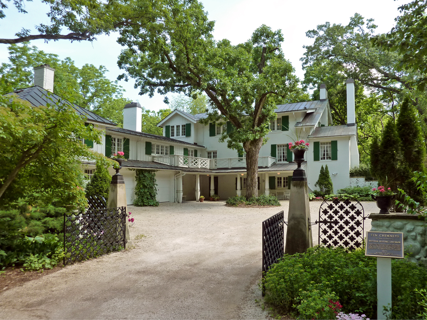
43°1′28″N 88°23′23″W / 43.02444°N 88.38972°WWales 127 Ten Chimneys 
February 23, 1998 S42 W31610 Depot Rd.
42°57′51″N 88°22′38″W / 42.96417°N 88.37722°WGenesee Summer home of actors Lynn Fontanne and Alfred Lunt; designated a U.S. National Historic Landmark on July 31, 2003 128 Third Street Bridge September 21, 1988 Roosevelt Dr.
43°10′55″N 88°6′52″W / 43.18194°N 88.11444°WMenomonee Falls 129 Totten-Butterfield House January 31, 1984 515 N. Grand Ave.
43°0′29″N 88°13′52″W / 43.00806°N 88.23111°WWaukesha 130 Trapp Filling Station December 8, 1986 252-256 W. Capitol Dr.
43°6′11″N 88°21′3″W / 43.10306°N 88.35083°WHartland 131 Christian Turck House October 25, 1973 Off WI 59 in Old World Wisconsin Eagle According to the Wisconsin Historical Society, the house is dismantled and in storage at Old World Wisconsin[5] 132 United Unitarian and Universalist Church October 1, 1987 216 Main St.
42°51′43″N 88°19′55″W / 42.86194°N 88.33194°WMukwonago 133 Sarah Belle Van Buren House December 8, 1986 128 Hill St.
43°6′18″N 88°20′54″W / 43.105°N 88.34833°WHartland 134 Village Park Bandstand September 21, 1988 Village Park on Garfield Dr.
43°10′32″N 88°7′7″W / 43.17556°N 88.11861°WMenomonee Falls 135 Visitation Convent Complex May 25, 2011 13105 Watertown Plank Rd.
43°2′42″N 88°4′31″W / 43.045°N 88.07528°WElm Grove 136 Ward District No. 3 Schoolhouse July 7, 1981 WI 67 and Betts Rd.
42°51′28″N 88°29′41″W / 42.85778°N 88.49472°WEagle 137 Stephen Warren House December 8, 1986 235 E. Capitol Dr.
43°6′16″N 88°20′36″W / 43.10444°N 88.34333°WHartland 138 Waukesha Post Office October 28, 1983 235 W. Broadway Ave.
43°0′39″N 88°13′49″W / 43.01083°N 88.23028°WWaukesha 139 Waukesha Pure Food Company October 28, 1983 550 Elizabeth St.
43°0′16″N 88°14′19″W / 43.00444°N 88.23861°WWaukesha 140 C. A. Welch House October 28, 1983 1616 White Rock Ave.
43°1′27″N 88°13′8″W / 43.02417°N 88.21889°WWaukesha 141 Deacon West Octagon House 
May 12, 1975 370 High St.
43°5′16″N 88°15′54″W / 43.08778°N 88.265°WPewaukee 142 Weston's Antique Apple Orchard September 6, 1996 19760 W. National Ave.
42°56′38″N 88°9′45″W / 42.94389°N 88.1625°WNew Berlin 143 Michael Wick Farmhouse and Barn September 21, 1988 N72 W13449 Good Hope Rd.
43°8′53″N 88°4′39″W / 43.14806°N 88.0775°WMenomonee Falls 144 Wisconsin Avenue Historic District October 28, 1983 Wisconsin
43°0′35″N 88°13′52″W / 43.00972°N 88.23111°WWaukesha 145 Wisconsin Industrial School for Boys January 21, 1987 621 and 627 W. College Ave.
43°0′8″N 88°14′27″W / 43.00222°N 88.24083°WWaukesha 146 Louis Yanke Saloon October 28, 1983 200 Madison Ave.
43°0′46″N 88°14′4″W / 43.01278°N 88.23444°WWaukesha 147 Johann Zimmer Farmhouse September 21, 1988 W156 N9390 Pilgrim Rd.
43°11′18″N 88°6′10″W / 43.18833°N 88.10278°WMenomonee Falls 148 Zion Evangelical Lutheran Church December 8, 1986 403 W. Capitol Dr.
43°6′6″N 88°21′11″W / 43.10167°N 88.35306°WHartland Formerly listed and other
[3] Landmark name Image Date listed Location City or town Summary 1 Mukwonago High School May 12, 2009[6] 308 Washington Ave. Mukwonago Added on October 7, 1994.[4] In addition, St. James Catholic Church and Cemetery, a Romanesque, Gothic Revival church at W220 N6588 Town Line Rd. in Menomonee Falls, Wisconsin, was nominated for NRHP listing, and deemed eligible, as part of the Menomonee Falls MRA, but it was not finally listed due to owner objection.
See also
- List of National Historic Landmarks in Wisconsin
- National Register of Historic Places listings in Wisconsin
References
- ^ "National Register of Historic Places: Weekly List Actions". National Park Service, United States Department of the Interior. Retrieved on November 10, 2011.
- ^ The latitude and longitude information provided is primarily from the National Register Information System, and has been found to be fairly accurate for about 99% of listings. For 1%, the location info may be way off. We seek to correct the coordinate information wherever it is found to be erroneous. Please leave a note in the Discussion page for this article if you believe any specific location is incorrect.
- ^ a b Numbers represent an ordering by significant words. Various colorings, defined here, differentiate National Historic Landmark sites and National Register of Historic Places Districts from other NRHP buildings, structures, sites or objects.
- ^ a b "National Register Information System". National Register of Historic Places. National Park Service. . http://nrhp.focus.nps.gov/natreg/docs/All_Data.html.
- ^ "Wisconsin Architecture & History Inventory". Madison, Wisconsin: Wisconsin Historical Society. http://www.wisconsinhistory.org/ahi/index.asp. Retrieved October 14, 2009.
- ^ "Weekly List". National Park Service. May 22, 2009. http://www.nps.gov/history/nr/listings/20090522.HTM. Retrieved May 24, 2009.
U.S. National Register of Historic Places Topics Lists by states Alabama • Alaska • Arizona • Arkansas • California • Colorado • Connecticut • Delaware • Florida • Georgia • Hawaii • Idaho • Illinois • Indiana • Iowa • Kansas • Kentucky • Louisiana • Maine • Maryland • Massachusetts • Michigan • Minnesota • Mississippi • Missouri • Montana • Nebraska • Nevada • New Hampshire • New Jersey • New Mexico • New York • North Carolina • North Dakota • Ohio • Oklahoma • Oregon • Pennsylvania • Rhode Island • South Carolina • South Dakota • Tennessee • Texas • Utah • Vermont • Virginia • Washington • West Virginia • Wisconsin • WyomingLists by territories Lists by associated states Other Municipalities and communities of Waukesha County, Wisconsin Cities Brookfield | Delafield | Milwaukee‡ | Muskego | New Berlin | Oconomowoc | Pewaukee | Waukesha

Villages Big Bend | Butler | Chenequa | Dousman | Eagle | Elm Grove | Hartland | Lac La Belle‡ | Lannon | Menomonee Falls | Merton | Mukwonago‡ | Nashotah | North Prairie | Pewaukee | Oconomowoc Lake | Sussex | Wales
Towns CDP Unincorporated
communitiesColgate‡ | Genesee Depot | Goerke's Corners | Lake Five | Mapleton | Monches | Monterey | North Lake | Saylesville | Stone Bank | Summit Center | Summit Corners | Vernon
Ghost towns Footnotes ‡This populated place also has portions in an adjacent county or counties
Categories:- Waukesha County, Wisconsin
- Lists of historic places in Wisconsin
-


Wikimedia Foundation. 2010.