- National Register of Historic Places listings in Pottawatomie County, Oklahoma
-
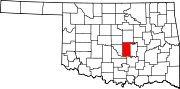
 Location of Pottawatomie County in Oklahoma
This is a list of the National Register of Historic Places listings in Pottawatomie County, Oklahoma.
This is intended to be a complete list of the properties and districts on the National Register of Historic Places in Pottawatomie County, Oklahoma, United States. The locations of National Register properties and districts for which the latitude and longitude coordinates are included below, may be seen in a Google map.[1]
There are 18 properties and districts listed on the National Register in the county.
-
- This National Park Service list is complete through NPS recent listings posted November 10, 2011.[2]
Current listings
[3] Landmark name [4] Image Date listed Location City or town Summary 1 Aldridge Hotel June 2, 2000 20-24 E. 9th St.
35°19′44″N 96°55′19″W / 35.328889°N 96.921944°WShawnee 2 Barnard Elementary School June 2, 2000 315 E. Locust St.
35°15′15″N 96°56′01″W / 35.254167°N 96.933611°WTecumseh 3 Beard Cabin 
April 8, 1983 Woodland Park
35°19′54″N 96°55′18″W / 35.331667°N 96.921667°WShawnee 4 Bell Street Historic District December 28, 2000 Along N. Bell St. from E. 9th to East Main
35°19′40″N 96°55′18″W / 35.327778°N 96.921667°WShawnee 5 Billington Building September 26, 1985 23 E. 9th
35°19′43″N 96°56′00″W / 35.328611°N 96.933333°WShawnee 6 H. T. Douglas Mansion and Garage September 26, 1985 100 E. Federal
35°21′16″N 96°55′17″W / 35.354444°N 96.921389°WShawnee 7 Governors Mansion January 21, 1983 618 N. Park St.
35°20′09″N 96°55′36″W / 35.335833°N 96.926667°WShawnee 8 Kerfoot House January 21, 1983 740 N. Beard St.
35°20′19″N 96°55′27″W / 35.338611°N 96.924167°WShawnee 9 Nuckolls House January 21, 1983 200 E. Federal St.
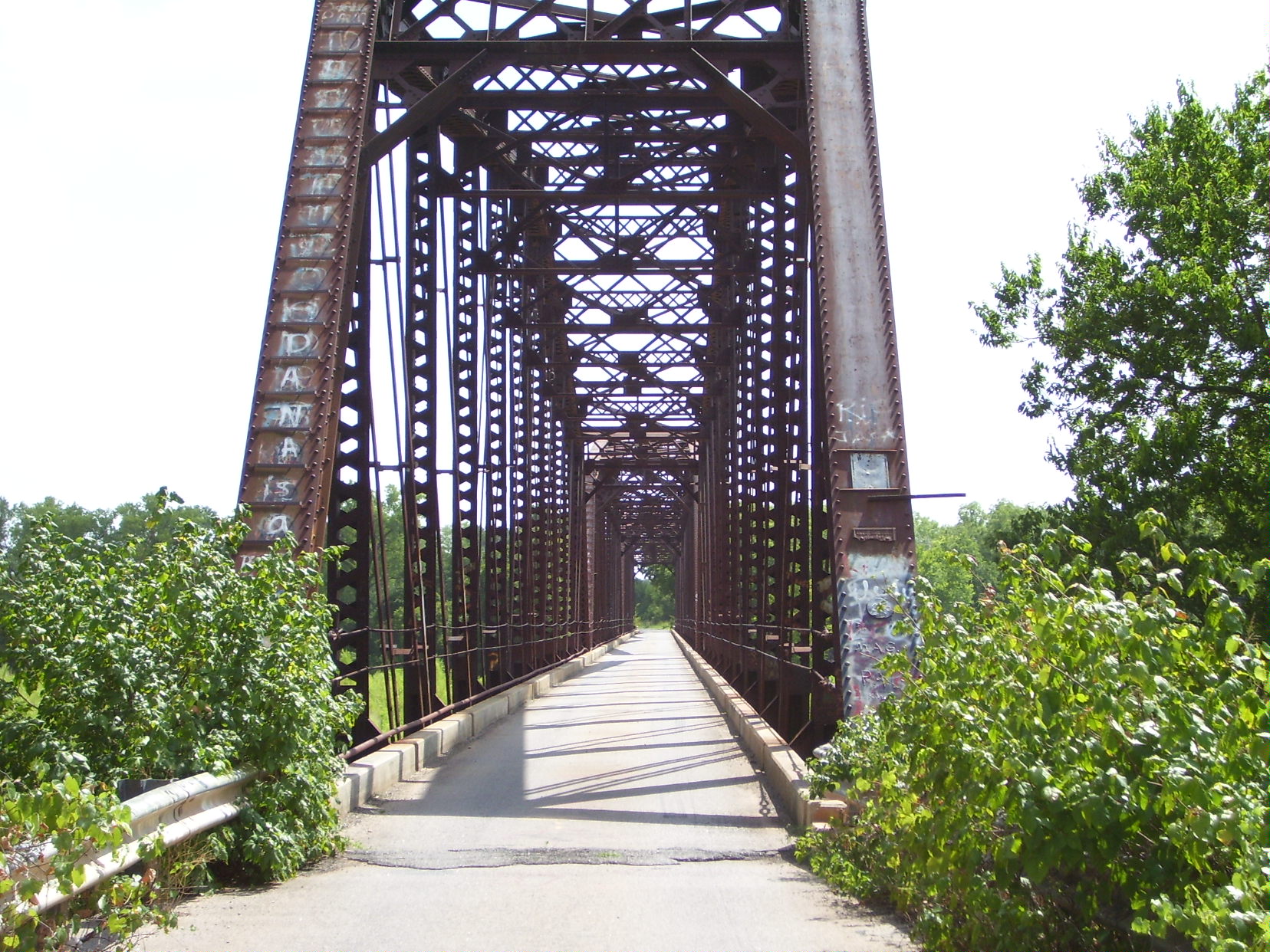
35°21′17″N 96°55′13″W / 35.354722°N 96.920278°WShawnee 10 Old Santa Fe Railroad Bridge 
March 10, 2010 Drummond Rd.
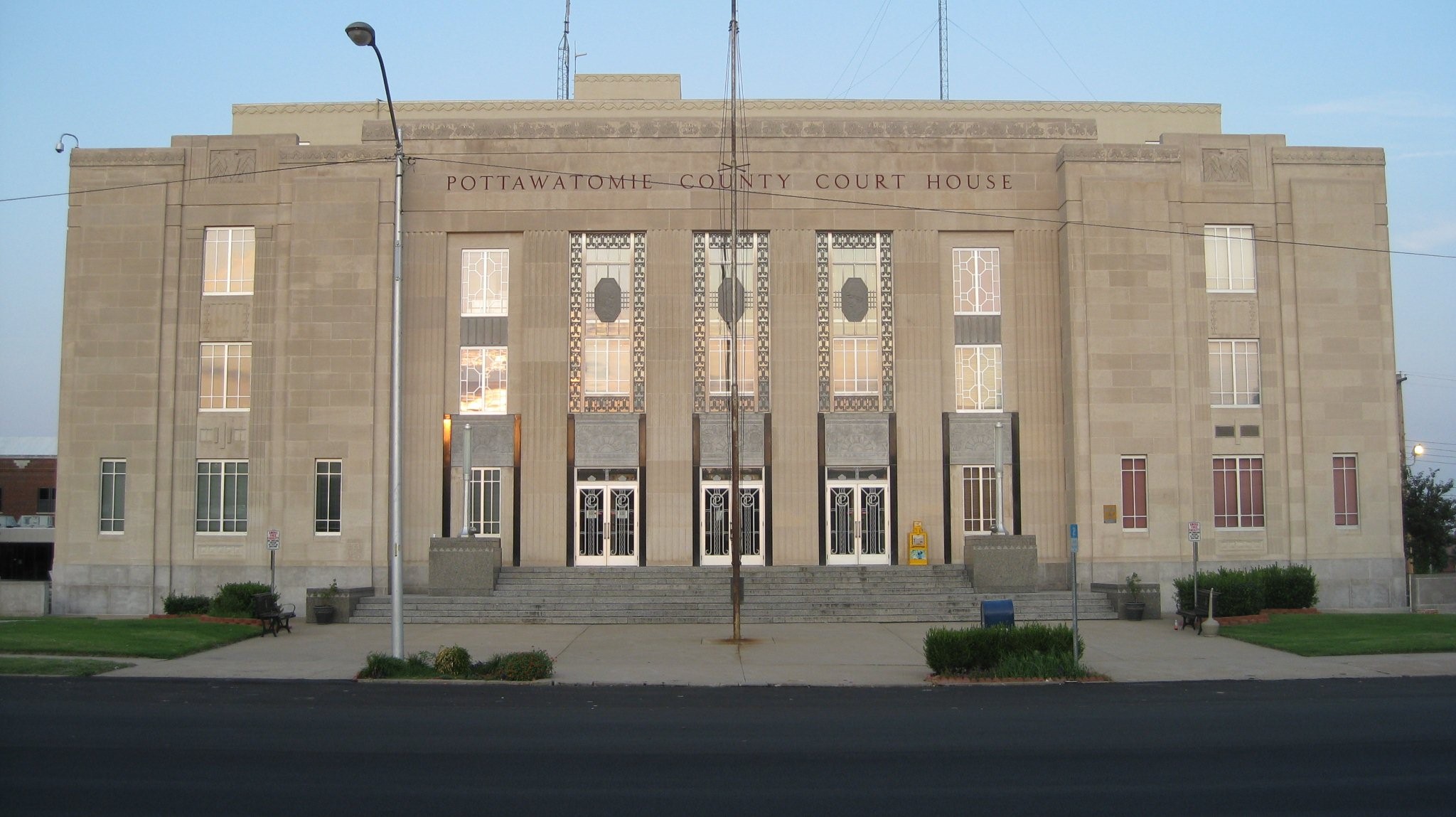
34°55′09″N 97°03′01″W / 34.91925°N 97.050322°WWanette Also known as the Wanette-Byers Bridge[5] 11 Pottawatomie County Courthouse 
August 24, 1984 300 N. Broadway
35°19′51″N 96°55′21″W / 35.330833°N 96.9225°WShawnee 12 Rose-Fast Site (34PT28) December 24, 1986 Address Restricted Harjo 13 Sacred Heart Mission Site 
September 15, 1983 Off State Highway 39
35°00′04″N 96°48′33″W / 35.001111°N 96.809169°WAsher 14 St. Gregory's Abbey and College August 15, 1975 1900 W. MacArthur Dr.
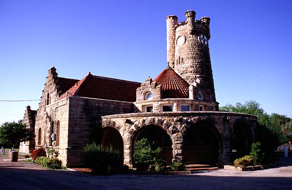
35°22′03″N 96°57′14″W / 35.3675°N 96.953889°WShawnee 15 Santa Fe Depot 
June 5, 1974 Main St. and Minnesota Ave.
35°19′41″N 96°54′57″W / 35.328056°N 96.915833°WShawnee 16 Shawnee Friends Mission March 7, 1973 2 miles south of Shawnee
35°17′50″N 96°55′42″W / 35.297222°N 96.928333°WShawnee 17 Squirrel Creek Bridge September 3, 2010 Carries Rangeline Rd. over Squirrel Creek
35°18′01″N 96°55′48″W / 35.300278°N 96.93°WShawnee vicinity 18 Walker House April 8, 1983 1801 N. Broadway
35°21′03″N 96°55′22″W / 35.350833°N 96.922778°WShawnee See also
- List of National Historic Landmarks in Oklahoma
- National Register of Historic Places listings in Oklahoma
References
- ^ The latitude and longitude information provided in this table was derived originally from the National Register Information System, which has been found to be fairly accurate for about 99% of listings. For about 1% of NRIS original coordinates, experience has shown that one or both coordinates are typos or otherwise extremely far off; some corrections may have been made. A more subtle problem causes many locations to be off by up to 150 yards, depending on location in the country: most NRIS coordinates were derived from tracing out latitude and longitudes off of USGS topographical quadrant maps created under the North American Datum of 1927, which differs from the current, highly accurate WGS84 GPS system used by Google maps. Chicago is about right, but NRIS longitudes in Washington are higher by about 4.5 seconds, and are lower by about 2.0 seconds in Maine. Latitudes differ by about 1.0 second in Florida. Some locations in this table may have been corrected to current GPS standards.
- ^ "National Register of Historic Places: Weekly List Actions". National Park Service, United States Department of the Interior. Retrieved on November 10, 2011.
- ^ Numbers represent an ordering by significant words. Various colorings, defined here, differentiate National Historic Landmark sites and National Register of Historic Places Districts from other NRHP buildings, structures, sites or objects.
- ^ "National Register Information System". National Register of Historic Places. National Park Service. . http://nrhp.focus.nps.gov/natreg/docs/All_Data.html.
- ^ "Wanette-Byers Bridge". March 21, 2010. http://bridgehunter.com/ok/pottawatomie/700000000000/. Retrieved March 22, 2010.
U.S. National Register of Historic Places Topics Lists by states Alabama • Alaska • Arizona • Arkansas • California • Colorado • Connecticut • Delaware • Florida • Georgia • Hawaii • Idaho • Illinois • Indiana • Iowa • Kansas • Kentucky • Louisiana • Maine • Maryland • Massachusetts • Michigan • Minnesota • Mississippi • Missouri • Montana • Nebraska • Nevada • New Hampshire • New Jersey • New Mexico • New York • North Carolina • North Dakota • Ohio • Oklahoma • Oregon • Pennsylvania • Rhode Island • South Carolina • South Dakota • Tennessee • Texas • Utah • Vermont • Virginia • Washington • West Virginia • Wisconsin • WyomingLists by territories Lists by associated states Other Municipalities and communities of Pottawatomie County, Oklahoma Cities Maud‡ | Oklahoma City‡ | Shawnee | Tecumseh
Towns Unincorporated
communityGhost town Avoca | Keokuk Falls
Footnotes ‡This populated place also has portions in an adjacent county or counties
Categories:- Pottawatomie County, Oklahoma
- National Register of Historic Places in Oklahoma by county
- Buildings and structures in Pottawatomie County, Oklahoma
-


Wikimedia Foundation. 2010.