- National Register of Historic Places listings in Hamilton County, Indiana
-
 Location of Hamilton County in Indiana
This is a list of the National Register of Historic Places listings in Hamilton County, Indiana.
This is intended to be a complete list of the properties and districts on the National Register of Historic Places in Hamilton County, Indiana, United States. Latitude and longitude coordinates are provided for many National Register properties and districts; these locations may be seen together in a Google map.[1]
There are 29 properties and districts listed on the National Register in the county.
-
- This National Park Service list is complete through NPS recent listings posted November 10, 2011.[2]
Current listings
[3] Landmark name [4] Image Date listed Location City or town Summary 1 George Boxley Cabin September 15, 2005 Pioneer Hill at 1st and Main Sts.
40°08′21″N 86°13′16″W / 40.139167°N 86.221111°WSheridan 2 Castor Farm Site December 8, 2008 Address Restricted Noblesville 3 Catherine Street Historic District 
September 16, 2001 Roughly bounded by Harrison, Clinton, the western side of 9th, and the eastern side of 10th
40°02′54″N 86°00′46″W / 40.048333°N 86.012778°WNoblesville 4 Cole-Evans House 
September 22, 2000 1012 Monument St.
40°03′04″N 86°00′43″W / 40.051111°N 86.011944°WNoblesville 5 Conner Street Historic District 
March 12, 1999 Roughly both sides of Logan and Conner Sts. between 10th and 17th
40°02′46″N 86°00′29″W / 40.046111°N 86.008056°WNoblesville 6 William Conner House 
February 8, 1980 13400 Allisonville Rd.
39°59′04″N 86°01′53″W / 39.984444°N 86.031389°WFishers 7 William Houston Craig House 
May 24, 1990 1250 E. Conner St.
40°02′45″N 86°00′34″W / 40.045833°N 86.009444°WNoblesville 8 Daniel Craycraft House 
January 4, 1989 1095 E. Conner St.
40°02′43″N 86°00′39″W / 40.045278°N 86.010833°WNoblesville 9 Davenport-Bradfield House January 18, 1985 106 E. 2nd St.
40°08′13″N 86°13′11″W / 40.136944°N 86.219722°WSheridan 10 Hamilton County Courthouse Square 
May 10, 1978 Bounded by Logan, 8th, 9th, and Conner Sts.
40°02′45″N 86°00′51″W / 40.045833°N 86.014167°WNoblesville 11 Dr. Samuel Harrell House 
March 1, 1984 399 N. 10th St.
40°02′56″N 86°00′44″W / 40.048889°N 86.012222°WNoblesville 12 Holliday Hydroelectric Powerhouse and Dam June 9, 1995 Riverwood Ave. at its junction with 211th St., across the White River
40°05′42″N 85°58′08″W / 40.095°N 85.968889°WNoblesville 13 John Kinzer House September 5, 1975 East of Carmel on State Road 234
39°58′44″N 86°06′32″W / 39.978889°N 86.108889°WCarmel 14 Micah Newby House June 20, 1986 1149 W. 116th St.
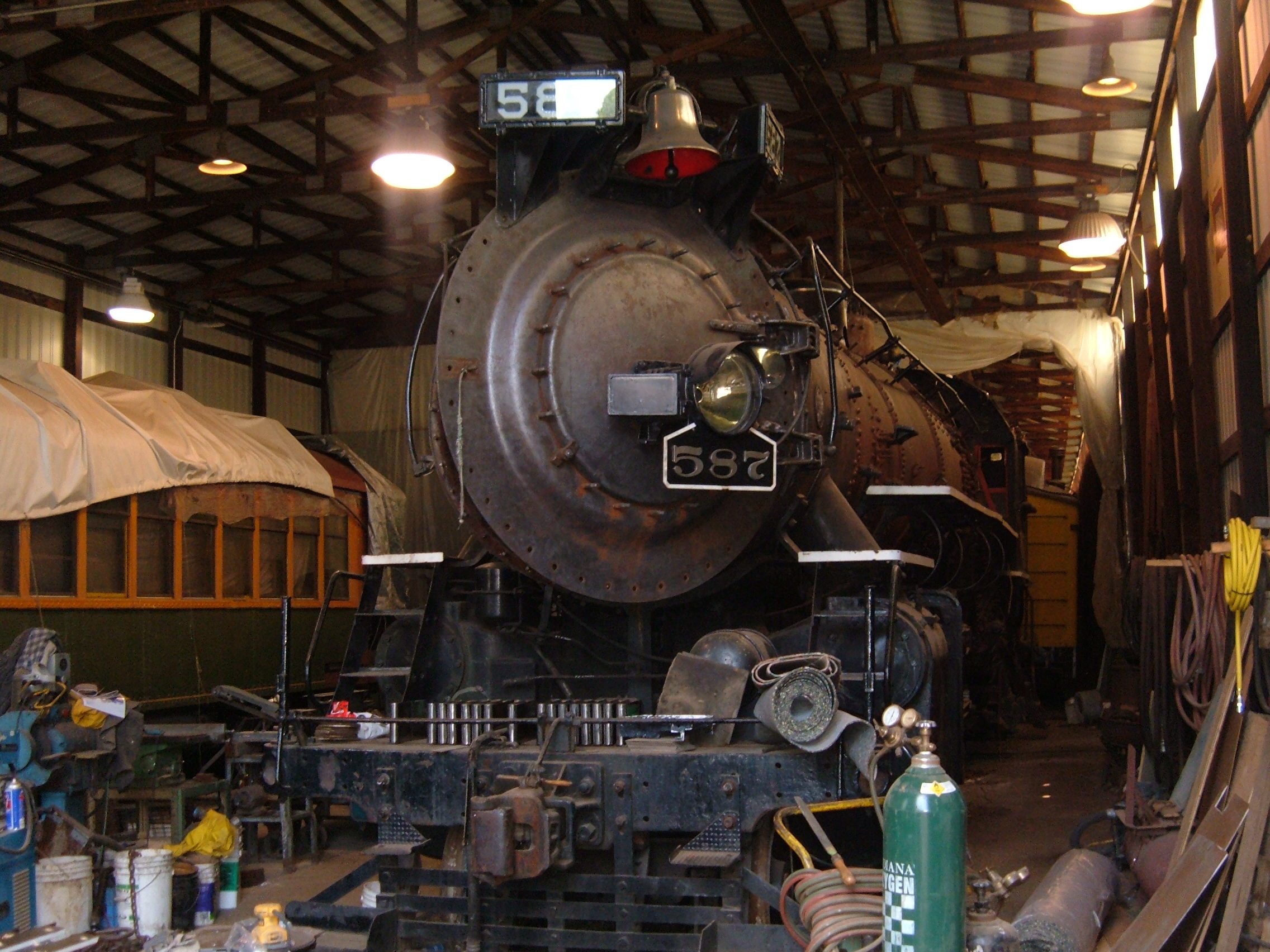
39°57′19″N 86°10′37″W / 39.955278°N 86.176944°WCarmel 15 Nickel Plate Road Steam Locomotive No. 587 
November 28, 1984 Indiana Transportation Museum
40°03′30″N 86°01′15″W / 40.058472°N 86.020833°WNoblesville 16 Noblesville Commercial Historic District 
December 19, 1991 Roughly bounded by Clinton, 10th, Maple, and 8th Sts.
40°02′44″N 86°00′49″W / 40.045556°N 86.013611°WNoblesville 17 Noblesville Milling Company Mill 
December 7, 2001 S. 8th St.
40°02′30″N 86°00′55″W / 40.041667°N 86.015278°WNoblesville 18 Potter's Covered Bridge 
December 19, 1991 Allisonville Rd. across the White River
40°04′21″N 86°00′02″W / 40.0725°N 86.000556°WNoblesville 19 Roads Hotel 
December 30, 1987 150 E. Main St.
40°12′57″N 86°01′31″W / 40.215833°N 86.025278°WAtlanta 20 Roberts Chapel 
September 25, 1996 3102 E. 276th St.
40°11′26″N 86°06′50″W / 40.190556°N 86.113889°WAtlanta 21 Sheridan Downtown Commercial Historic District September 20, 2007 Roughly includes Main St. from E. 2nd to the old Monon Railroad right-of-way
40°08′14″N 86°13′14″W / 40.137086°N 86.220622°WSheridan 22 South 9th Street Historic District 
September 16, 2001 Roughly bounded by Maple, Division, 10th, and the western side of 9th St.
40°02′35″N 86°00′48″W / 40.043056°N 86.013333°WNoblesville 22 Judge Earl S. Stone House 
December 8, 1978 107 S. 8th St.
40°02′40″N 86°00′54″W / 40.044444°N 86.015°WNoblesville 24 Strawtown Enclosure March 19, 2008 Northern side of Strawtown Ave., west of Strawtown
40°7′35″N 85°57′6″W / 40.12639°N 85.95167°W[5]Noblesville 25 Taylor Ten December 24, 2009 Floodplain on the western side of a bend of the White River, southwest of Strawtown
40°6′54″N 85°58′36″W / 40.115°N 85.97667°W[6]Noblesville 26 Thornhurst Addition June 24, 2010 Bounded by 650 to 742 West Main St., Thornhurst Dr. and Rogers Ct.
39°58′44″N 86°08′16″W / 39.978889°N 86.137778°WCarmel 27 Union High Academy Historic District March 3, 1995 434 S. Union St.
40°02′19″N 86°07′34″W / 40.038611°N 86.126111°WWestfield 28 West-Harris House March 23, 1999 10595 Eller Rd.
39°56′31″N 86°03′55″W / 39.941944°N 86.065278°WFishers 29 Robert L. Wilson House 
September 17, 2008 273 S. 8th St.
40°02′35″N 86°00′56″W / 40.043194°N 86.015556°WNoblesville See also
- List of National Historic Landmarks in Indiana
- National Register of Historic Places listings in Indiana
References
- ^ The latitude and longitude information provided in this table was derived originally from the National Register Information System, which has been found to be fairly accurate for about 99% of listings. For about 1% of NRIS original coordinates, experience has shown that one or both coordinates are typos or otherwise extremely far off; some corrections may have been made. A more subtle problem causes many locations to be off by up to 150 yards, depending on location in the country: most NRIS coordinates were derived from tracing out latitude and longitudes off of USGS topographical quadrant maps created under the North American Datum of 1927, which differs from the current, highly accurate WGS84 GPS system used by Google maps. Chicago is about right, but NRIS longitudes in Washington are higher by about 4.5 seconds, and are lower by about 2.0 seconds in Maine. Latitudes differ by about 1.0 second in Florida. Some locations in this table may have been corrected to current GPS standards.
- ^ "National Register of Historic Places: Weekly List Actions". National Park Service, United States Department of the Interior. Retrieved on November 10, 2011.
- ^ Numbers represent an ordering by significant words. Various colorings, defined here, differentiate National Historic Landmark sites and National Register of Historic Places Districts from other NRHP buildings, structures, sites or objects.
- ^ "National Register Information System". National Register of Historic Places. National Park Service. . http://nrhp.focus.nps.gov/natreg/docs/All_Data.html.
- ^ Location derived from coordinates; the NRIS provides coordinates but lists the property as "Address Restricted".
- ^ Location derived from McCord, Beth K. "Archaeological Investigations at the Hobbs' Knob (12M266) and Taylor Ten (12H987) Sites, Madison and Hamilton County, Indiana". Indiana Archaeology 5.1 (2010): 70-92: 72. The NRIS lists the site as "Address Restricted".
U.S. National Register of Historic Places Topics Lists by states Alabama • Alaska • Arizona • Arkansas • California • Colorado • Connecticut • Delaware • Florida • Georgia • Hawaii • Idaho • Illinois • Indiana • Iowa • Kansas • Kentucky • Louisiana • Maine • Maryland • Massachusetts • Michigan • Minnesota • Mississippi • Missouri • Montana • Nebraska • Nevada • New Hampshire • New Jersey • New Mexico • New York • North Carolina • North Dakota • Ohio • Oklahoma • Oregon • Pennsylvania • Rhode Island • South Carolina • South Dakota • Tennessee • Texas • Utah • Vermont • Virginia • Washington • West Virginia • Wisconsin • WyomingLists by territories Lists by associated states Other Municipalities and communities of Hamilton County, Indiana Cities 
Towns Townships Adams | Clay | Delaware | Fall Creek | Jackson | Noblesville | Washington | Wayne | White River
Unincorporated
communitiesAroma | Bakers Corner | Boxley | Brooks | Chesterton | Clare | Clarksville | College Meadows | Deming | Durbin | Echo Crest | Eagletown | Hawthorn Hills | Holaday Hills and Dales | Home Place | Hortonville | Jolietville | Lamong | Luxhaven | Millersburg | New Britton | North Augusta Addition | North Ridge Village | Northern Beach | Northwood Hills | Omega | Orchard Park | Riverwood | Strawtown | Trails End | Walnut Grove
Categories:- Hamilton County, Indiana
- National Register of Historic Places in Indiana by county
-


Wikimedia Foundation. 2010.