- National Register of Historic Places listings in Hall County, Nebraska
-
 Location of Hall County in Nebraska
This is a list of the National Register of Historic Places listings in Hall County, Nebraska. It is intended to be a complete list of the properties and districts on the National Register of Historic Places in Hall County, Nebraska, United States. The locations of National Register properties and districts for which the latitude and longitude coordinates are included below, may be seen in a Google map.[1]
There are 21 properties and districts listed on the National Register in the county.
-
- This National Park Service list is complete through NPS recent listings posted November 10, 2011.[2]
Listings county-wide
[3] Landmark name Image Date listed Location City or town Summary 1 H.J. Bartenbach House 
December 8, 1986 720 W. Division
40°55′13″N 98°20′43″W / 40.920278°N 98.345278°WGrand Island 2 Cathedral of the Nativity of the Blessed Virgin Mary 
July 15, 1982 204 S. Cedar St.
40°55′16″N 98°20′32″W / 40.921111°N 98.342222°WGrand Island 3 Evangelische Lutherische Dreienigkeit Kirche 
December 1, 1986 512 E. 2nd St.
40°55′38″N 98°20′04″W / 40.927222°N 98.334444°WGrand Island 4 Heinrich Giese House 
July 26, 2006 2226 S. Blaine
40°53′59″N 98°21′55″W / 40.899722°N 98.365278°WGrand Island 5 Glade-Donald House 
September 12, 1985 1004 W. Division
40°55′09″N 98°20′53″W / 40.919167°N 98.348056°WGrand Island 6 Gloe Brothers Service Station 
July 5, 2000 609 E. 11th St.
40°49′20″N 98°35′38″W / 40.822222°N 98.593889°WWood River 7 Grand Island Carnegie Library 
May 2, 1975 321 W. 2nd St.
40°55′25″N 98°20′30″W / 40.923611°N 98.341667°WGrand Island 8 Grand Island FCC Monitoring Station 
January 16, 1973 609 N. Monitor Road[4]
40°55′33″N 98°26′08″W / 40.925833°N 98.435556°WGrand Island 9 Grand Island Senior High School 
November 22, 1999 504 Elm St.
40°55′44″N 98°21′01″W / 40.928889°N 98.350278°WGrand Island 10 Grand Island United States Post Office and Courthouse 
February 14, 2006 203 W. 2nd St.
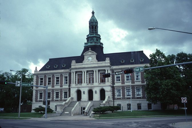
40°55′27″N 98°20′25″W / 40.924167°N 98.340278°WGrand Island 11 Hall County Courthouse 
September 15, 1977 1st and Locust
40°55′25″N 98°20′20″W / 40.923611°N 98.338889°WGrand Island 12 Hamilton-Donald House 
March 13, 1986 820 W. 2nd St.
40°55′18″N 98°20′52″W / 40.921667°N 98.347778°WGrand Island 13 Andrew M. Hargis House 
June 9, 1978 1109 W. 2nd St.
40°55′13″N 98°21′00″W / 40.920278°N 98.35°WGrand Island 14 Hotel Yancey 
December 13, 1984 123 N. Locust St.
40°55′28″N 98°20′23″W / 40.924444°N 98.339722°WGrand Island 15 Lee Huff Apartment Complex 
July 1, 1994 213-215½ S. Walnut St., 324 W. Koenig St., and 316-318½ W. Koenig St.
40°55′16″N 98°20′25″W / 40.921111°N 98.340278°WGrand Island 16 Liederkranz 
November 30, 1978 401 W. 1st St.
40°55′21″N 98°20′30″W / 40.9225°N 98.341667°WGrand Island 17 Nine Bridges Bridge 
June 29, 1992 Private road over the Middle Channel of the Platte River, 3.9 miles north of Doniphan
40°49′40″N 98°22′47″W / 40.827778°N 98.379722°WDoniphan 18 Oscar Roeser House 
June 25, 1982 721 W. Koenig St.
40°55′09″N 98°20′40″W / 40.919167°N 98.344444°WGrand Island 19 Shady Bend Gas Station, Grocery, and Diner 
July 2, 2008 3609 E. U.S. Route 30
40°56′19″N 98°18′03″W / 40.93858°N 98.30074°WGrand Island 20 Stolley Homestead Site 
March 16, 1972 Stolley Park Grand Island 21 Townsley-Murdock Immigrant Trail Site 
March 5, 1998 Approximately 1.5 miles south of Alda
40°50′42″N 98°28′27″W / 40.845°N 98.474167°WAlda See also
- List of National Historic Landmarks in Nebraska
- National Register of Historic Places listings in Nebraska
References
- ^ The latitude and longitude information provided in this table was derived originally from the National Register Information System, which has been found to be fairly accurate for about 99% of listings. For about 1% of NRIS original coordinates, experience has shown that one or both coordinates are typos or otherwise extremely far off; some corrections may have been made. A more subtle problem causes many locations to be off by up to 150 yards, depending on location in the country: most NRIS coordinates were derived from tracing out latitude and longitudes off of USGS topographical quadrant maps created under North American Datum of 1927, which differs from the current, highly accurate GPS system used by Google maps. Chicago is about right, but NRIS longitudes in Washington are higher by about 4.5 seconds, and are lower by about 2.0 seconds in Maine. Latitudes differ by about 1.0 second in Florida. Some locations in this table may have been corrected to current GPS standards.
- ^ "National Register of Historic Places: Weekly List Actions". National Park Service, United States Department of the Interior. Retrieved on November 10, 2011.
- ^ Numbers represent an ordering by significant words. Various colorings, defined here, differentiate National Historic Landmark sites and National Register of Historic Places Districts from other NRHP buildings, structures, sites or objects.
- ^ See photo
U.S. National Register of Historic Places Topics Lists by states Alabama • Alaska • Arizona • Arkansas • California • Colorado • Connecticut • Delaware • Florida • Georgia • Hawaii • Idaho • Illinois • Indiana • Iowa • Kansas • Kentucky • Louisiana • Maine • Maryland • Massachusetts • Michigan • Minnesota • Mississippi • Missouri • Montana • Nebraska • Nevada • New Hampshire • New Jersey • New Mexico • New York • North Carolina • North Dakota • Ohio • Oklahoma • Oregon • Pennsylvania • Rhode Island • South Carolina • South Dakota • Tennessee • Texas • Utah • Vermont • Virginia • Washington • West Virginia • Wisconsin • WyomingLists by territories Lists by associated states Other  Category:National Register of Historic Places •
  Portal:National Register of Historic Places
Municipalities and communities of Hall County, Nebraska County seat: Grand Island Cities 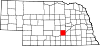
Villages Categories:- National Register of Historic Places in Nebraska by county
- Hall County, Nebraska
- Buildings and structures in Hall County, Nebraska
-


Wikimedia Foundation. 2010.