- National Register of Historic Places listings in Fillmore County, Nebraska
-
 Location of Fillmore County in Nebraska
This is a list of the National Register of Historic Places listings in Fillmore County, Nebraska.
This is intended to be a complete list of the properties and districts on the National Register of Historic Places in Fillmore County, Nebraska, United States. The locations of National Register properties and districts for which the latitude and longitude coordinates are included below, may be seen in a Google map.[1]
There are 19 properties and districts listed on the National Register in the county.
-
- This National Park Service list is complete through NPS recent listings posted November 10, 2011.[2]
Current listings
[3] Landmark name Image Date listed Location City or town Summary 1 The Auditorium 
September 28, 1988 160 N. 9th
40°31′36″N 97°36′10″W / 40.526667°N 97.602778°WGeneva 2 Belle Prairie Township Hall & Strang Town Hall-Jail 
November 29, 1991 Main St.
40°24′50″N 97°35′13″W / 40.413889°N 97.586944°WStrang 3 Big Blue River Bridge 
June 29, 1992 County road over the West Fork of the Big Blue River, 5 miles north and 1 mile west of Grafton
40°41′47″N 97°43′44″W / 40.696389°N 97.728889°WGrafton 4 J.M. Burk House 
February 23, 2001 331 N. 11th St.
40°31′45″N 97°35′54″W / 40.529167°N 97.598333°WGeneva 5 Cesko-narodni sin-Milligan Auditorium 
February 29, 1996 Southwestern corner of the junction of Main and Birch Sts.
40°30′08″N 97°23′30″W / 40.502222°N 97.391667°WMilligan 6 Deering Bridge 
June 29, 1992 County road over School Creek, 2 miles north and 2 miles east of Sutton
40°38′26″N 97°49′27″W / 40.640556°N 97.824167°WSutton Extends into Clay County 7 Dempster-Sloan House 
March 15, 2005 1212 M St.
40°32′01″N 97°35′49″W / 40.533611°N 97.596944°WGeneva 8 Philip and Addie Ellis Eberhardt Farmstead March 14, 1991 3 miles north of U.S. Route 6
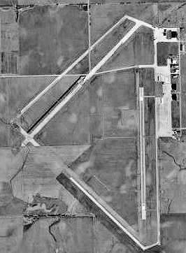
40°40′51″N 97°27′34″W / 40.680833°N 97.459444°WExeter 9 Fairmont Army Airfield 
March 11, 2003 Approximately 2 miles south of Fairmont
40°35′22″N 97°34′35″W / 40.589444°N 97.576389°WFairmont 10 Fairmont Creamery Company Building 
December 15, 1983 Southeast of 6th Ave. and F St.
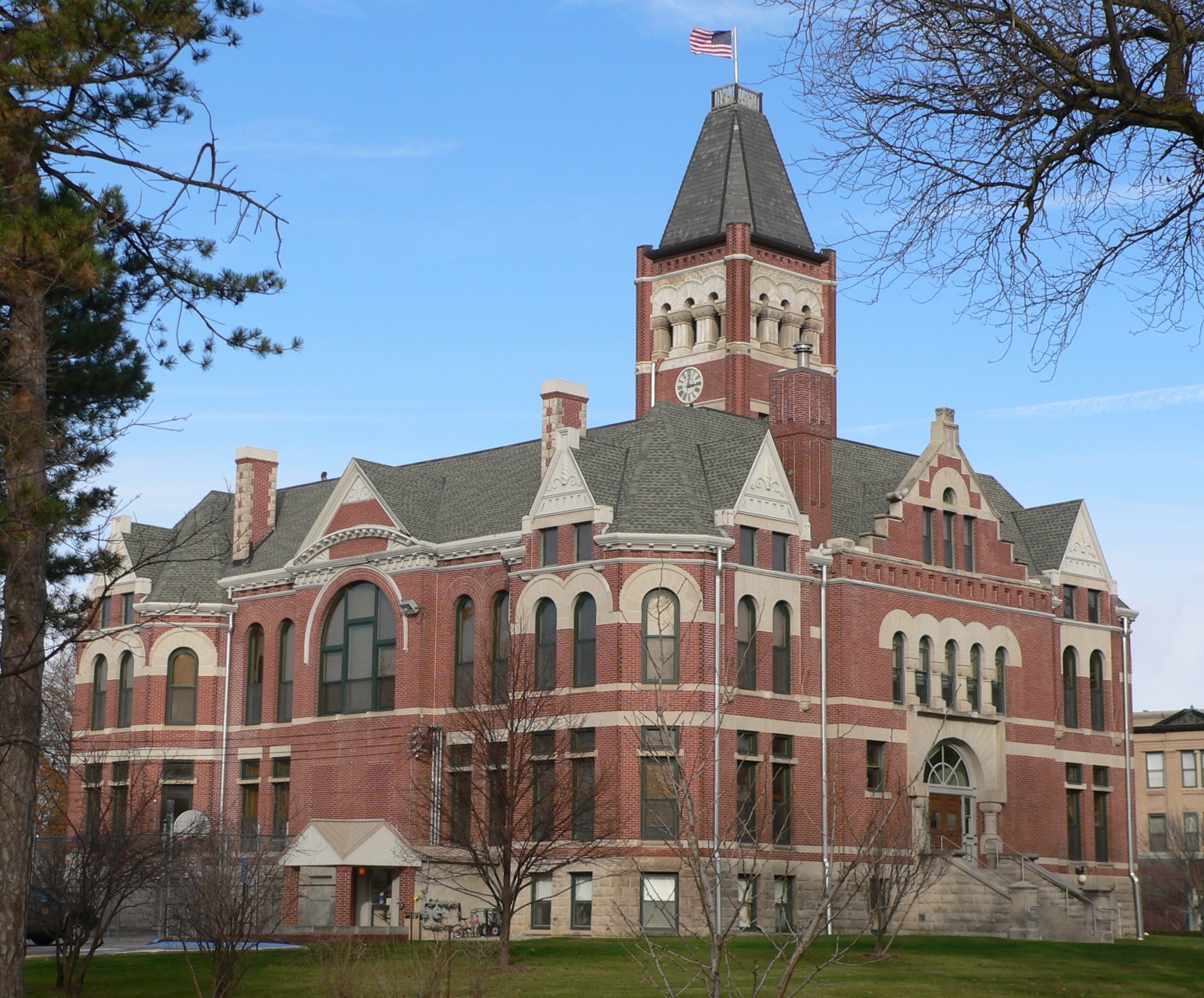
40°38′06″N 97°35′05″W / 40.635°N 97.584722°WFairmont 11 Fillmore County Courthouse 
December 12, 1978 9th and G Sts.
40°31′30″N 97°36′09″W / 40.525°N 97.6025°WGeneva 12 Lincoln Telephone & Telegraph Exchange Building in Fairmount 
March 2, 2006 635 6th Ave.
40°38′05″N 97°35′07″W / 40.634722°N 97.585278°WFairmont 13 Maple Grove Sales Pavilion and Farrowing Barn July 16, 2009 2408 Rd. W
40°22′49″N 97°22′47″W / 40.38014°N 97.37984°WTobias 14 Ohiowa Public School 
July 22, 2005 202 S. Main St.
40°24′39″N 97°27′12″W / 40.410833°N 97.453333°WOhiowa 15 George W. Smith House 
May 8, 1986 12th St. between I and J Sts.
40°31′45″N 97°35′51″W / 40.529167°N 97.5975°WGeneva 16 Stockholm Swedish Lutheran Church and Cemetery 
June 30, 1995 2.5 miles west and 0.5 miles south of Shickley
40°24′36″N 97°46′41″W / 40.41°N 97.778056°WShickley 17 Strang School District No. 36 
June 25, 1992 Main St.
40°24′43″N 97°35′13″W / 40.411944°N 97.586944°WStrang 18 US Post Office-Geneva 
May 11, 1992 202 N. 9th St.
40°31′38″N 97°36′10″W / 40.527222°N 97.602778°WGeneva 19 Warner's Filling Station and House 
July 12, 2006 737 and 745 G St.
40°31′31″N 97°36′17″W / 40.525278°N 97.604722°WGeneva See also
- List of National Historic Landmarks in Nebraska
- National Register of Historic Places listings in Nebraska
References
- ^ The latitude and longitude information provided in this table was derived originally from the National Register Information System, which has been found to be fairly accurate for about 99% of listings. For about 1% of NRIS original coordinates, experience has shown that one or both coordinates are typos or otherwise extremely far off; some corrections may have been made. A more subtle problem causes many locations to be off by up to 150 yards, depending on location in the country: most NRIS coordinates were derived from tracing out latitude and longitudes off of USGS topographical quadrant maps created under the North American Datum of 1927, which differs from the current, highly accurate WGS84 GPS system used by Google maps. Chicago is about right, but NRIS longitudes in Washington are higher by about 4.5 seconds, and are lower by about 2.0 seconds in Maine. Latitudes differ by about 1.0 second in Florida. Some locations in this table may have been corrected to current GPS standards.
- ^ "National Register of Historic Places: Weekly List Actions". National Park Service, United States Department of the Interior. Retrieved on November 10, 2011.
- ^ Numbers represent an ordering by significant words. Various colorings, defined here, differentiate National Historic Landmark sites and National Register of Historic Places Districts from other NRHP buildings, structures, sites or objects.
U.S. National Register of Historic Places Topics Lists by states Alabama • Alaska • Arizona • Arkansas • California • Colorado • Connecticut • Delaware • Florida • Georgia • Hawaii • Idaho • Illinois • Indiana • Iowa • Kansas • Kentucky • Louisiana • Maine • Maryland • Massachusetts • Michigan • Minnesota • Mississippi • Missouri • Montana • Nebraska • Nevada • New Hampshire • New Jersey • New Mexico • New York • North Carolina • North Dakota • Ohio • Oklahoma • Oregon • Pennsylvania • Rhode Island • South Carolina • South Dakota • Tennessee • Texas • Utah • Vermont • Virginia • Washington • West Virginia • Wisconsin • WyomingLists by territories Lists by associated states Other Municipalities and communities of Fillmore County, Nebraska City 
Villages Townships Categories:- National Register of Historic Places in Nebraska by county
- Fillmore County, Nebraska
- Buildings and structures in Fillmore County, Nebraska
-


Wikimedia Foundation. 2010.