- Ohiowa, Nebraska
-
Ohiowa, Nebraska — Village — Downtown Ohiowa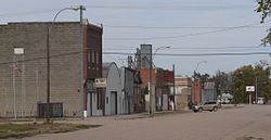 Location of Ohiowa, Nebraska
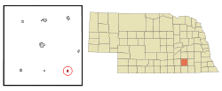
Coordinates: 40°24′51″N 97°27′8″W / 40.41417°N 97.45222°WCoordinates: 40°24′51″N 97°27′8″W / 40.41417°N 97.45222°W Country United States State Nebraska County Fillmore Area – Total 0.2 sq mi (0.6 km2) – Land 0.2 sq mi (0.6 km2) – Water 0.0 sq mi (0.0 km2) Elevation 1,588 ft (484 m) Population (2010) – Total 115 – Density 573.4/sq mi (221.4/km2) Time zone Central (CST) (UTC-6) – Summer (DST) CDT (UTC-5) ZIP code 68416 Area code(s) 402 FIPS code 31-36015[1] GNIS feature ID 0831836[2] Ohiowa is a village in Fillmore County, Nebraska, United States. The population was 115 at the 2010 census.
Contents
Geography
Ohiowa is located at 40°24′51″N 97°27′8″W / 40.41417°N 97.45222°W (40.414057, -97.452190)[3].
According to the United States Census Bureau, the village has a total area of 0.2 square miles (0.52 km2), all of it land.
Demographics
As of the census[1] of 2000, there were 142 people, 69 households, and 34 families residing in the village. The population density was 573.4 people per square mile (219.3/km²). There were 78 housing units at an average density of 315.0 per square mile (120.5/km²). The racial makeup of the village was 94.37% White, 0.70% African American, 2.11% from other races, and 2.82% from two or more races. Hispanic or Latino of any race were 7.04% of the population.
There were 69 households out of which 18.8% had children under the age of 18 living with them, 42.0% were married couples living together, 7.2% had a female householder with no husband present, and 50.7% were non-families. 46.4% of all households were made up of individuals and 30.4% had someone living alone who was 65 years of age or older. The average household size was 2.06 and the average family size was 2.97.
In the village the population was spread out with 19.0% under the age of 18, 6.3% from 18 to 24, 26.1% from 25 to 44, 19.0% from 45 to 64, and 29.6% who were 65 years of age or older. The median age was 44 years. For every 100 females there were 84.4 males. For every 100 females age 18 and over, there were 76.9 males.
The median income for a household in the village was $20,625, and the median income for a family was $28,125. Males had a median income of $23,333 versus $13,750 for females. The per capita income for the village was $12,526. There were 25.8% of families and 33.1% of the population living below the poverty line, including 73.1% of under eighteens and 22.0% of those over 64.
Notable residents
- Mato Kosyk, Sorbian writer
References
- ^ a b "American FactFinder". United States Census Bureau. http://factfinder.census.gov. Retrieved 2008-01-31.
- ^ "US Board on Geographic Names". United States Geological Survey. 2007-10-25. http://geonames.usgs.gov. Retrieved 2008-01-31.
- ^ "US Gazetteer files: 2010, 2000, and 1990". United States Census Bureau. 2011-02-12. http://www.census.gov/geo/www/gazetteer/gazette.html. Retrieved 2011-04-23.
Municipalities and communities of Fillmore County, Nebraska City 
Villages Townships Categories:- Populated places in Fillmore County, Nebraska
- Villages in Nebraska


Wikimedia Foundation. 2010.