- National Register of Historic Places listings in Alcorn County, Mississippi
-
 Location of Alcorn County in Mississippi
This is a list of the National Register of Historic Places listings in Alcorn County, Mississippi.
This is intended to be a complete list of the properties and districts on the National Register of Historic Places in Alcorn County, Mississippi, United States. Latitude and longitude coordinates are provided for many National Register properties and districts; these locations may be seen together in a Google map.[1]
There are 20 properties and districts listed on the National Register in the county, including 1 National Historic Landmark.
-
- This National Park Service list is complete through NPS recent listings posted November 10, 2011.[2]
Current listings
[3] Landmark name [4] Image Date listed Location City or town Summary 1 Battery Williams April 11, 1977 Fulton Dr. at the former Southern railroad line
34°56′03″N 88°31′37″W / 34.934167°N 88.526944°WCorinth (See Siege and Battle of Corinth Sites ) 2 Battle of Corinth, Confederate Assault Position April 30, 1976 Shiloh Rd.
34°56′35″N 88°31′36″W / 34.943056°N 88.526667°WCorinth (See Siege and Battle of Corinth Sites ) 3 Dr. Joseph M. Bynum House November 24, 1997 48 S. Front St.
34°45′42″N 88°31′40″W / 34.761667°N 88.527778°WRienzi 4 Coliseum Theatre August 21, 1980 404 Taylor St.
34°56′02″N 88°31′06″W / 34.933889°N 88.518333°WCorinth 5 Corinth Clothing Manufacturing Company Building November 17, 2004 Tate St. at Davis St.
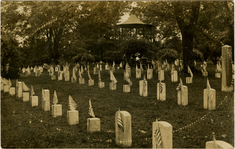
34°55′54″N 88°31′10″W / 34.931667°N 88.519444°WCorinth 6 Corinth National Cemetery 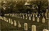
November 20, 1996 1551 Horton St.
34°55′35″N 88°30′36″W / 34.926389°N 88.51°WCorinth (See Siege and Battle of Corinth Sites ) 7 Thomas F. Dilworth House September 15, 1988 West off U.S. Route 45, south of Biggersville
34°49′41″N 88°35′40″W / 34.828056°N 88.594444°WBiggersville 8 Downtown Corinth Historic District January 28, 1993 Roughly bounded by Wick, Jackson, Foote and Webster Sts.
34°56′02″N 88°31′11″W / 34.933889°N 88.519722°WCorinth 9 Federal Siege Trench November 13, 1976 North of Corinth off U.S. Route 45
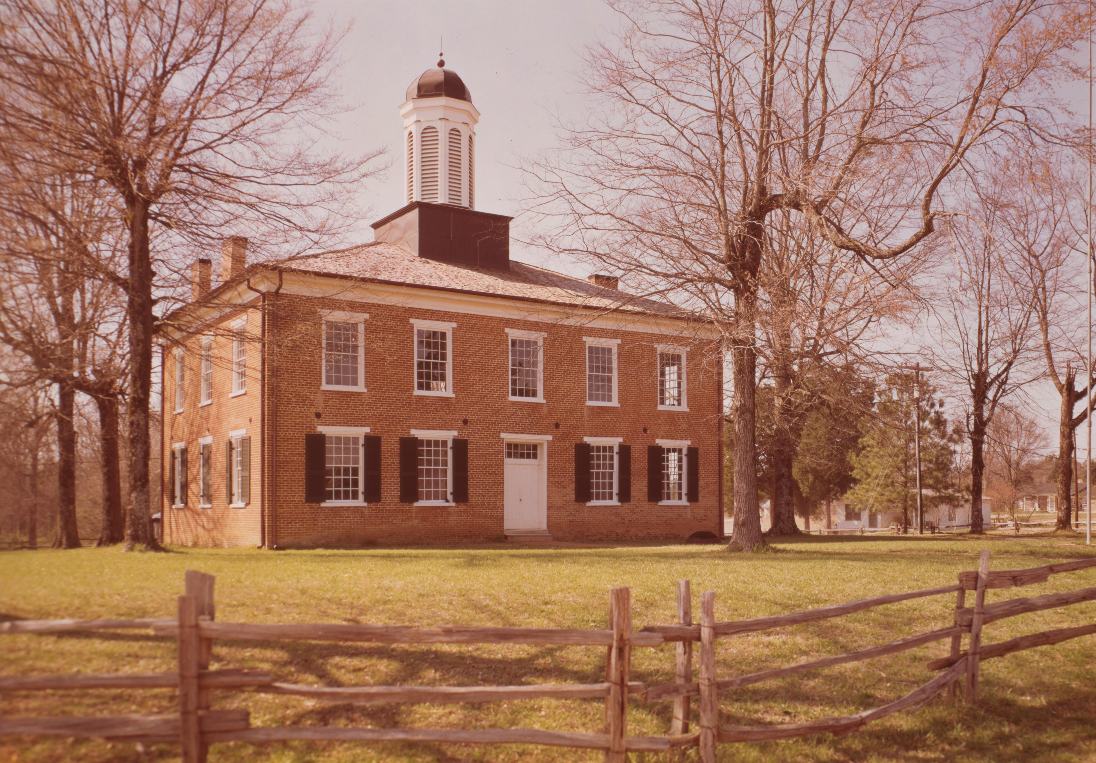
34°58′40″N 88°30′09″W / 34.977778°N 88.5025°WCorinth (See Siege and Battle of Corinth Sites ) 10 Fort Robinette April 11, 1972 Robinette St. Corinth (See Siege and Battle of Corinth Sites ) 11 Jacinto Courthouse 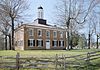
November 25, 1969 Route 1
34°45′41″N 88°25′41″W / 34.761389°N 88.428056°WRienzi 12 Midtown Corinth Historic District December 23, 1993 Roughly bounded by Cass, Bunch, Washington, Main, Filmore, Linden, Douglas, and Cruise Sts.
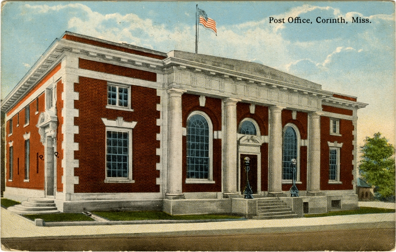
34°56′11″N 88°31′03″W / 34.936389°N 88.5175°WCorinth 13 Moores Creek Site July 7, 1975 Address Restricted Rienzi 14 Old US Post Office 
January 29, 1992 515 Fillmore St.
34°56′08″N 88°31′14″W / 34.935556°N 88.520556°WCorinth 15 Rienzi Commercial Historic District November 7, 1996 Junction of Front and Main Sts.
34°45′49″N 88°31′41″W / 34.763611°N 88.528056°WRienzi 16 Siege and Battle of Corinth May 6, 1991 Various locations in and around the town of Corinth
34°57′12″N 88°31′10″W / 34.953333°N 88.519444°WCorinth National Historic Landmark district including numerous sites 17 L.C. Steele House July 16, 1992 515 4th St.
34°56′34″N 88°31′05″W / 34.942778°N 88.518056°WCorinth 18 Union Battery F, Battle of Corinth September 10, 1987 Rabbitt Ranch Rd.
34°56′53″N 88°33′06″W / 34.948056°N 88.551667°WCorinth (See Siege and Battle of Corinth Sites ) 19 Union Earthworks July 25, 1997 0.5 miles northeast of the junction of U.S. Route 45 and Mississippi Highway 356
34°46′02″N 88°32′53″W / 34.767222°N 88.548056°WRienzi (See Siege and Battle of Corinth Sites ) 20 Veranda House August 22, 1975 711 Jackson St.
34°56′13″N 88°31′16″W / 34.936944°N 88.521111°WCorinth See also
- List of National Historic Landmarks in Mississippi
- National Register of Historic Places listings in Mississippi
References
- ^ The latitude and longitude information provided in this table was derived originally from the National Register Information System, which has been found to be fairly accurate for about 99% of listings. For about 1% of NRIS original coordinates, experience has shown that one or both coordinates are typos or otherwise extremely far off; some corrections may have been made. A more subtle problem causes many locations to be off by up to 150 yards, depending on location in the country: most NRIS coordinates were derived from tracing out latitude and longitudes off of USGS topographical quadrant maps created under the North American Datum of 1927, which differs from the current, highly accurate WGS84 GPS system used by Google maps. Chicago is about right, but NRIS longitudes in Washington are higher by about 4.5 seconds, and are lower by about 2.0 seconds in Maine. Latitudes differ by about 1.0 second in Florida. Some locations in this table may have been corrected to current GPS standards.
- ^ "National Register of Historic Places: Weekly List Actions". National Park Service, United States Department of the Interior. Retrieved on November 10, 2011.
- ^ Numbers represent an ordering by significant words. Various colorings, defined here, differentiate National Historic Landmark sites and National Register of Historic Places Districts from other NRHP buildings, structures, sites or objects.
- ^ "National Register Information System". National Register of Historic Places. National Park Service. . http://nrhp.focus.nps.gov/natreg/docs/All_Data.html.
U.S. National Register of Historic Places Topics Lists by states Alabama • Alaska • Arizona • Arkansas • California • Colorado • Connecticut • Delaware • Florida • Georgia • Hawaii • Idaho • Illinois • Indiana • Iowa • Kansas • Kentucky • Louisiana • Maine • Maryland • Massachusetts • Michigan • Minnesota • Mississippi • Missouri • Montana • Nebraska • Nevada • New Hampshire • New Jersey • New Mexico • New York • North Carolina • North Dakota • Ohio • Oklahoma • Oregon • Pennsylvania • Rhode Island • South Carolina • South Dakota • Tennessee • Texas • Utah • Vermont • Virginia • Washington • West Virginia • Wisconsin • WyomingLists by territories Lists by associated states Other Municipalities and communities of Alcorn County, Mississippi Cities 
Towns Farmington | Glen | Rienzi
Villages Unincorporated
communitiesJacinto | Wenasoga
Categories:- Alcorn County, Mississippi
- National Register of Historic Places in Mississippi by county
- Buildings and structures in Alcorn County, Mississippi
-

Wikimedia Foundation. 2010.