- National Register of Historic Places listings in Lawrence County, South Dakota
-
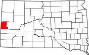
 Location of Lawrence County in South Dakota
This is a list of the National Register of Historic Places listings in Lawrence County, South Dakota.
This is intended to be a complete list of the properties and districts on the National Register of Historic Places in Lawrence County, South Dakota, United States. The locations of National Register properties and districts for which the latitude and longitude coordinates are included below, may be seen in a Google map.[1]
There are 50 properties and districts listed on the National Register in the county, including 2 National Historic Landmarks.
-
- This National Park Service list is complete through NPS recent listings posted November 10, 2011.[2]
Current listings
[3] Landmark name [4] Image Date listed Location City or town Summary 1 Oliver N. Ainsworth House October 25, 1990 340 Kansas
44°29′35″N 103°51′18″W / 44.493056°N 103.855°WSpearfish 2 Baker Bungalow October 24, 1996 740 8th St.
44°29′29″N 103°51′19″W / 44.491389°N 103.855278°WSpearfish 3 Henry Buskala Ranch November 13, 1985 FDR 206
44°12′27″N 103°48′11″W / 44.2075°N 103.803056°WDumont 4 Fayette Cook House July 13, 1988 840 8th Ave.
44°29′33″N 103°51′20″W / 44.4925°N 103.855556°WSpearfish 5 James A. Corbin House October 25, 1990 345 Main St.
44°29′11″N 103°51′28″W / 44.486389°N 103.857778°WSpearfish 6 Henry Court House October 25, 1990 329 Main St.
44°29′10″N 103°51′28″W / 44.486111°N 103.857778°WSpearfish 7 Dakota Tin and Gold Mine June 8, 2005 20896 Fillmore Mine Ln.
44°22′23″N 104°02′02″W / 44.373056°N 104.033889°WSpearfish 8 Deadwood Historic District 
October 15, 1966 Bounded by the city limits
44°22′19″N 103°44′00″W / 44.371944°N 103.733333°WDeadwood 9 Eleazer C. and Gwinnie Dickey House July 13, 1989 735 8th St.
44°29′28″N 103°51′21″W / 44.491111°N 103.855833°WSpearfish 10 Walter Dickey House May 16, 1988 815 State St.
44°29′31″N 103°51′17″W / 44.491944°N 103.854722°WSpearfish 11 William D. Driskill House July 13, 1989 335 Canyon St.
44°29′10″N 103°51′39″W / 44.486111°N 103.860833°WSpearfish 12 Episcopal Church of All Angels April 22, 1976 129 W. Michigan
44°29′38″N 103°51′38″W / 44.493889°N 103.860556°WSpearfish 13 Robert H. Evans House November 1, 1991 258 Evans Ln.
44°30′25″N 103°52′06″W / 44.506944°N 103.868333°WSpearfish 14 Frawley Historic Ranch 
December 31, 1974 6 miles east of Spearfish on U.S. Route 14
44°28′30″N 103°42′38″W / 44.475°N 103.710556°WSpearfish 15 Galena School November 30, 1999 Block 13, Lots 1-5 Bryan Placer No. 913
44°19′42″N 103°38′47″W / 44.328333°N 103.646389°WGalena 16 Halloran-Matthews-Brady House December 12, 1976 214 E. Jackson St.
44°29′30″N 103°51′26″W / 44.491667°N 103.857222°WSpearfish 17 Jerome and Jonetta Harvey Homestead Cabin September 12, 2008 Township 3, Range 2, Track A of Homestead Entry Survey 71 Lead 18 Arthur Hewes House October 25, 1990 811 St. Joe
44°29′29″N 103°52′07″W / 44.491389°N 103.868611°WSpearfish 19 John Hill Ranch-Keltomaki November 13, 1985 Northeast of Brownsville
44°17′11″N 103°39′11″W / 44.286389°N 103.653056°WBrownsville 20 Homestake Workers House November 1, 1991 830 State St.
44°29′32″N 103°51′15″W / 44.492222°N 103.854167°WSpearfish 21 Henry Keets House July 13, 1988 344 E. Illinois
44°29′27″N 103°51′16″W / 44.490833°N 103.854444°WSpearfish 22 Webb S. Knight House July 13, 1989 514 7th St.
44°29′19″N 103°51′22″W / 44.488611°N 103.856111°WSpearfish 23 Kroll Meat Market and Slaughterhouse May 20, 1988 Spearfish city park
44°29′06″N 103°51′38″W / 44.485°N 103.860556°WSpearfish 24 Lead Historic District 
December 31, 1974 Roughly bounded by the city limits
44°21′06″N 103°45′45″W / 44.351667°N 103.7625°WLead 25 William Ernest Lown House May 28, 1976 745 5th St.
44°29′26″N 103°51′38″W / 44.490556°N 103.860556°WSpearfish 26 The Mail Building May 16, 1988 731 Main St.
44°29′26″N 103°51′32″W / 44.490556°N 103.858889°WSpearfish 27 McLaughlin Ranch Barn February 14, 2002 410 N. Rainbow Rd.
44°28′46″N 103°46′06″W / 44.479444°N 103.768333°WSpearfish 28 Mount Theodore Roosevelt Monument December 22, 2005 Black Hills National Forest
44°23′53″N 103°45′33″W / 44.398056°N 103.759167°WDeadwood 29 Nemo School House July 17, 1996 Nemo Rd.
44°11′34″N 97°30′15″W / 44.192778°N 97.504167°WNemo 30 Old Finnish Lutheran Church November 13, 1985 Sinking Gardens, E. Main St.
44°21′09″N 103°45′50″W / 44.3525°N 103.763889°WLead 31 Thomas Quillian House November 1, 1991 W. Center St.
44°32′49″N 103°43′23″W / 44.546944°N 103.723056°WSaint Onge 32 Old Redwater Bridge December 9, 1993 Local road over the Redwater River
44°35′24″N 103°51′22″W / 44.59°N 103.856111°WSpearfish 33 Almira Riley House July 13, 1989 938 Ames
44°29′35″N 103°52′04″W / 44.493056°N 103.867778°WSpearfish 34 St. Lawrence O'Toole Catholic Church February 5, 2003 618 Main
44°22′10″N 103°45′58″W / 44.369444°N 103.766111°WCentral City 35 St. Onge Schoolhouse May 7, 1980 Off Highway 24
44°32′47″N 103°43′26″W / 44.546389°N 103.723889°WSaint Onge 36 Saint Onge State Bank October 26, 2005 214 Center St.
44°32′56″N 103°43′14″W / 44.548889°N 103.720556°WSaint Onge 37 Spearfish City Hall October 25, 1990 722 Main St.
44°29′27″N 103°51′31″W / 44.490833°N 103.858611°WSpearfish 38 Spearfish Filling Station May 16, 1988 706 Main St.
44°29′25″N 103°51′30″W / 44.490278°N 103.858333°WSpearfish 39 Spearfish Fisheries Center May 19, 1978 South of Spearfish off U.S. Route 14
44°28′52″N 103°51′36″W / 44.481111°N 103.86°WSpearfish 40 Spearfish Historic Commercial District June 5, 1975 544, 545, 603-645 Main St., 114-136 W. Illinois St., and 701-703 5th St.
44°29′22″N 103°51′32″W / 44.489444°N 103.858889°WSpearfish 41 Old Spearfish Post Office February 12, 1999 526 Main St.
44°28′13″N 103°51′30″W / 44.470278°N 103.858333°WSpearfish 42 Tomahawk Lake Country Club October 26, 2005 U.S. Route 385
44°17′27″N 103°41′07″W / 44.290833°N 103.685278°WDeadwood 43 Toomey House November 7, 1997 1011 Main St.
44°29′36″N 103°51′35″W / 44.493333°N 103.859722°WSpearfish 44 Otto L. Uhlig House July 13, 1989 230 Jackson
44°29′30″N 103°51′23″W / 44.491667°N 103.856389°WSpearfish 45 Walsh Barn May 30, 2003 0.5 miles west of the junction of Upper Redwater Rd. and 104th Ave.
44°34′47″N 103°59′19″W / 44.579722°N 103.988611°WSpearfish 46 Walton Ranch May 30, 2005 221 Upper Valley Rd.
44°30′38″N 103°52′50″W / 44.510556°N 103.880556°WSpearfish 47 Whitewood Historic District June 8, 2007 1005-1021 Meade St.
44°27′46″N 103°38′23″W / 44.462778°N 103.639722°WWhitewood 48 Mary Whitney House October 25, 1990 704 8th St.
44°29′27″N 103°51′19″W / 44.490833°N 103.855278°WSpearfish 49 John Wolzmuth House July 13, 1988 814 8th Ave.
44°29′31″N 103°51′20″W / 44.491944°N 103.855556°WSpearfish 50 Woodmen Hall November 14, 1991 Junction of Center and 2nd Sts.
44°32′49″N 103°43′12″W / 44.546944°N 103.72°WSaint Onge See also
- List of National Historic Landmarks in South Dakota
- National Register of Historic Places listings in South Dakota
References
- ^ The latitude and longitude information provided in this table was derived originally from the National Register Information System, which has been found to be fairly accurate for about 99% of listings. For about 1% of NRIS original coordinates, experience has shown that one or both coordinates are typos or otherwise extremely far off; some corrections may have been made. A more subtle problem causes many locations to be off by up to 150 yards, depending on location in the country: most NRIS coordinates were derived from tracing out latitude and longitudes off of USGS topographical quadrant maps created under the North American Datum of 1927, which differs from the current, highly accurate WGS84 GPS system used by Google maps. Chicago is about right, but NRIS longitudes in Washington are higher by about 4.5 seconds, and are lower by about 2.0 seconds in Maine. Latitudes differ by about 1.0 second in Florida. Some locations in this table may have been corrected to current GPS standards.
- ^ "National Register of Historic Places: Weekly List Actions". National Park Service, United States Department of the Interior. Retrieved on November 10, 2011.
- ^ Numbers represent an ordering by significant words. Various colorings, defined here, differentiate National Historic Landmark sites and National Register of Historic Places Districts from other NRHP buildings, structures, sites or objects.
- ^ "National Register Information System". National Register of Historic Places. National Park Service. . http://nrhp.focus.nps.gov/natreg/docs/All_Data.html.
U.S. National Register of Historic Places Topics Lists by states Alabama • Alaska • Arizona • Arkansas • California • Colorado • Connecticut • Delaware • Florida • Georgia • Hawaii • Idaho • Illinois • Indiana • Iowa • Kansas • Kentucky • Louisiana • Maine • Maryland • Massachusetts • Michigan • Minnesota • Mississippi • Missouri • Montana • Nebraska • Nevada • New Hampshire • New Jersey • New Mexico • New York • North Carolina • North Dakota • Ohio • Oklahoma • Oregon • Pennsylvania • Rhode Island • South Carolina • South Dakota • Tennessee • Texas • Utah • Vermont • Virginia • Washington • West Virginia • Wisconsin • WyomingLists by territories Lists by associated states Other Municipalities and communities of Lawrence County, South Dakota Cities Central City | Deadwood | Lead | Spearfish | Whitewood
CDP Township Unincorporated
communitiesHanna | Nemo | Saint Onge
Categories:- Lawrence County, South Dakota
- National Register of Historic Places in South Dakota by county
- Buildings and structures in Lawrence County, South Dakota
-


Wikimedia Foundation. 2010.