- National Register of Historic Places listings in Emmons County, North Dakota
-
 Location of Emmons County in North Dakota
This is a list of the National Register of Historic Places listings in Emmons County, North Dakota.
This is intended to be a complete list of the properties and districts on the National Register of Historic Places in Emmons County, North Dakota, United States. The locations of National Register properties and districts for which the latitude and longitude coordinates are included below, may be seen in a Google map.[1]
There are 18 properties and districts listed on the National Register in the county.
Contents: Counties in North Dakota Adams | Barnes | Benson | Billings | Bottineau | Bowman | Burke | Burleigh | Cass | Cavalier | Dickey | Divide | Dunn | Eddy | Emmons | Foster | Golden Valley | Grand Forks | Grant | Griggs | Hettinger | Kidder | La Moure | Logan | McHenry | McIntosh | McKenzie | McLean | Mercer | Morton | Mountrail | Nelson | Oliver | Pembina | Pierce | Ramsey | Ransom | Renville | Richland | Rolette | Sargent | Sheridan | Sioux | Slope | Stark | Steele | Stutsman | Towner | Traill | Walsh | Ward | Wells | Williams -
- This National Park Service list is complete through NPS recent listings posted November 10, 2011.[2]
Listings county-wide
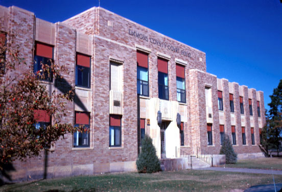
[3] Landmark name [4] Image Date listed Location City or town Summary 1 Emmons County Courthouse 
November 14, 1985 5th St.
46°16′01″N 100°14′11″W / 46.266944°N 100.236389°WLinton 2 Johannes Goldade House January 27, 1983 Southeast of Linton off ND 13
46°13′07″N 99°57′36″W / 46.218611°N 99.96°WLinton 3 Holy Trinity Cemetery, Wrought-Iron Cross Site A October 23, 1989 Address Restricted Strasburg 4 Holy Trinity Cemetery, Wrought-Iron Cross Site B October 23, 1989 Address Restricted Strasburg 5 Holy Trinity Cemetery, Wrought-Iron Cross Site C October 23, 1989 Address Restricted Strasburg 6 Holy Trinity Cemetery, Wrought-Iron Cross Site D October 23, 1989 Address Restricted Strasburg 7 Old St. Mary's Cemetery, Wrought-Iron Cross Site October 23, 1989 Address Restricted Hague 8 Sacred Heart Cemetery, Wrought-Iron Cross Site October 23, 1989 Address Restricted Linton 9 Saints Peter and Paul Catholic Church Complex September 25, 1986 1st Ave.
46°08′10″N 100°09′42″W / 46.136111°N 100.161667°WStrasburg 10 St. Aloysius Cemetery, Wrought-Iron Cross Site A October 23, 1989 Address Restricted Hague 11 St. Aloysius Cemetery, Wrought-Iron Cross Site B October 23, 1989 Address Restricted Hague 12 St. Mary's Cemetery, Wrought-Iron Cross Site A October 23, 1989 Address Restricted Hague 13 St. Mary's Cemetery, Wrought-Iron Cross Site B October 23, 1989 Address Restricted Hague 14 St. Mary's Cemetery, Wrought-Iron Cross Site C October 23, 1989 Address Restricted Hague 15 St. Mary's Church Non-Contiguous Historic District October 13, 1983 Off ND 11
46°01′41″N 100°01′01″W / 46.028056°N 100.016944°WHague 16 Tirsbol Cemetery, Wrought-Iron Cross Site October 23, 1989 Address Restricted Strasburg 17 Ludwig and Christina Welk Homestead October 28, 1993 2.5 miles northwest of Strasburg
46°09′01″N 100°12′27″W / 46.150278°N 100.2075°WStrasburg Birthplace of Lawrence Welk 18 Willows Hotel May 2, 1996 112 S. Broadway
46°15′59″N 100°13′58″W / 46.266389°N 100.232778°WLinton See also
- List of National Historic Landmarks in North Dakota
- National Register of Historic Places listings in North Dakota
References
- ^ The latitude and longitude information provided in this table was derived originally from the National Register Information System, which has been found to be fairly accurate for about 99% of listings. For about 1% of NRIS original coordinates, experience has shown that one or both coordinates are typos or otherwise extremely far off; some corrections may have been made. A more subtle problem causes many locations to be off by up to 150 yards, depending on location in the country: most NRIS coordinates were derived from tracing out latitude and longitudes off of USGS topographical quadrant maps created under the North American Datum of 1927, which differs from the current, highly accurate WGS84 GPS system used by Google maps. Chicago is about right, but NRIS longitudes in Washington are higher by about 4.5 seconds, and are lower by about 2.0 seconds in Maine. Latitudes differ by about 1.0 second in Florida. Some locations in this table may have been corrected to current GPS standards.
- ^ "National Register of Historic Places: Weekly List Actions". National Park Service, United States Department of the Interior. Retrieved on November 10, 2011.
- ^ Numbers represent an ordering by significant words. Various colorings, defined here, differentiate National Historic Landmark sites and National Register of Historic Places Districts from other NRHP buildings, structures, sites or objects.
- ^ "National Register Information System". National Register of Historic Places. National Park Service. . http://nrhp.focus.nps.gov/natreg/docs/All_Data.html.
U.S. National Register of Historic Places Topics Lists by states Alabama • Alaska • Arizona • Arkansas • California • Colorado • Connecticut • Delaware • Florida • Georgia • Hawaii • Idaho • Illinois • Indiana • Iowa • Kansas • Kentucky • Louisiana • Maine • Maryland • Massachusetts • Michigan • Minnesota • Mississippi • Missouri • Montana • Nebraska • Nevada • New Hampshire • New Jersey • New Mexico • New York • North Carolina • North Dakota • Ohio • Oklahoma • Oregon • Pennsylvania • Rhode Island • South Carolina • South Dakota • Tennessee • Texas • Utah • Vermont • Virginia • Washington • West Virginia • Wisconsin • WyomingLists by territories Lists by associated states Other Municipalities and communities of Emmons County, North Dakota Cities 
Township Unorganized
territoriesNorth Emmons | South Emmons
Unincorporated
communitiesCategories:- National Register of Historic Places in North Dakota by county
- Emmons County, North Dakota
-

Wikimedia Foundation. 2010.