- National Register of Historic Places listings in Butte County, South Dakota
-
 Location of Butte County in South Dakota
This is a list of the National Register of Historic Places listings in Butte County, South Dakota.
This is intended to be a complete list of the properties and districts on the National Register of Historic Places in Butte County, South Dakota, United States. The locations of National Register properties and districts for which the latitude and longitude coordinates are included below, may be seen in a Google map.[1]
There are 35 properties and districts listed on the National Register in the county. Another 2 properties were once listed but have been removed.
-
- This National Park Service list is complete through NPS recent listings posted November 10, 2011.[2]
Current listings
[3] Landmark name [4] Image Date listed Location City or town Summary 1 Belle Fourche Commercial Historic District 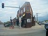
April 27, 1982 500-620 State St. and 608-622 5th Ave.
44°40′20″N 103°51′12″W / 44.672222°N 103.853333°WBelle Fourche 2 Belle Fourche Dam November 23, 1977 East of Belle Fourche off U.S. Route 212
44°44′06″N 103°40′28″W / 44.735°N 103.674444°WBelle Fourche 3 Belle Fourche Experiment Farm December 22, 1976 Northwest of Newell off Highway 79
44°43′45″N 103°27′01″W / 44.729167°N 103.450278°WNewell 4 Charles Bolles House July 1, 1982 919 State St.
44°40′18″N 103°50′44″W / 44.671667°N 103.845556°WBelle Fourche 5 Butte County Courthouse and Historic Jail Building December 3, 1998 839 5th Ave.
44°40′12″N 103°48′54″W / 44.67°N 103.815°WBelle Fourche 6 Butte-Lawrence County Fairgrounds April 30, 1986 Southwest of Nisland
44°40′02″N 97°34′04″W / 44.667222°N 97.567778°WNisland 7 Ditchrider House January 31, 2002 North of U.S. Route 212
44°40′46″N 103°33′31″W / 44.679444°N 103.558611°WNisland 8 Fruitdale School April 30, 1986 High St.
44°40′14″N 97°41′29″W / 44.670556°N 97.691389°WFruitdale 9 Fruitdale Store April 30, 1986 Water and Main Sts.
44°40′09″N 97°41′44″W / 44.669167°N 97.695556°WFruitdale 10 Carl Friedrick Gartner Homestead April 30, 1986 West of Highway 79
44°42′29″N 97°29′21″W / 44.708056°N 97.489167°WNewell 11 Thomas Haskins Gay House July 19, 1982 704 Harding
44°40′13″N 103°51′00″W / 44.670278°N 103.85°WBelle Fourche 12 Fred S. Harris House July 13, 1988 826 State St.
44°40′17″N 103°50′51″W / 44.671389°N 103.8475°WBelle Fourche 13 Hay Creek Bridge December 9, 1993 8th Ave. over Hay Creek
44°39′54″N 103°51′05″W / 44.665°N 103.851389°WBelle Fourche 14 Hoover Store April 30, 1986 Highway 79
45°06′45″N 97°16′16″W / 45.1125°N 97.271111°WHoover 15 Alexander Hoover House April 30, 1986 Highway 59
45°06′46″N 97°16′06″W / 45.112778°N 97.268333°WHoover 16 William Johnson House April 30, 1986 High St.
44°40′14″N 97°41′38″W / 44.670556°N 97.693889°WFruitdale 17 William G. Kenaston House February 23, 1984 301 Dartmouth
44°42′54″N 103°25′31″W / 44.715°N 103.425278°WNewell 18 Langdon School April 30, 1986 Snoma Rd.
44°38′59″N 97°28′45″W / 44.649722°N 97.479167°WNisland 19 Lincoln School February 9, 2001 706 Jackson
44°40′00″N 103°51′00″W / 44.666667°N 103.85°WBelle Fourche 20 Minnesela Bridge December 9, 1993 Local road over Redwater Creek
44°38′28″N 103°49′19″W / 44.641111°N 103.821944°WBelle Fourche 21 Newell Depot Bridge August 5, 1999 Local road over Horse Creek
44°42′20″N 103°29′10″W / 44.705556°N 103.486111°WNewell 22 Newell High School May 1, 1986 Dartmouth St.
44°43′04″N 97°25′34″W / 44.717778°N 97.426111°WNewell 23 John Aaron Scotney House January 3, 1978 830 9th St.
44°40′09″N 103°50′55″W / 44.669167°N 103.848611°WBelle Fourche 24 Charles and Eleanor Small House November 1, 1991 825 5th Ave.
44°40′09″N 103°51′10″W / 44.669167°N 103.852778°WBelle Fourche 25 Snoma Finnish Cemetery November 13, 1985 3.5 miles southeast of Fruitdale
44°37′59″N 103°41′06″W / 44.633056°N 103.685°WFruitdale 26 Soper-Behymer Ranch June 6, 1986 Highway 34
44°38′25″N 98°04′39″W / 44.640278°N 98.0775°WBelle Fourche 27 South Dakota Dept. of Transportation Bridge No. 10-109-360 December 9, 1993 Local road over the Diversion Dam Inlet Canal in the Belle Fourche Irrigation District
44°41′27″N 103°49′52″W / 44.690833°N 103.831111°WBelle Fourche 28 South Dakota Dept. of Transportation Bridge No. 10-270-338 February 18, 2000 Local road over Horse Creek
44°43′21″N 103°30′22″W / 44.7225°N 103.506111°WNewell 29 Stonelake Bridge April 30, 1986 Winkler Rd.
44°43′21″N 103°30′24″W / 44.7225°N 103.506667°WNewell 30 Tri State Bakery August 5, 1993 705 State St.
44°40′18″N 103°50′58″W / 44.671667°N 103.849444°WBelle Fourche 31 Vale Bridge August 5, 1999 Local road over the Belle Fourche River
44°37′45″N 103°23′13″W / 44.629167°N 103.386944°WVale 32 Vale Cut Off Belle Fourche River Bridge April 30, 1986 7 miles southwest of Newell
44°40′17″N 97°29′32″W / 44.671389°N 97.492222°WBelle Fourche 33 Vale School August 1, 1984 Off Highway 79
44°37′14″N 103°23′53″W / 44.620556°N 103.398056°WVale 34 Nicholas Augustus Viken Homestead April 30, 1986 North of Hope Cemetery Rd.
44°42′51″N 97°28′35″W / 44.714167°N 97.476389°WNewell 35 Wide Awake Grocery Building March 30, 1978 520 State St.
44°40′15″N 103°51′02″W / 44.670833°N 103.850556°WBelle Fourche Former listings
Landmark name Image Date Location City or Town Summary 1 Nisland Bridge March 26, 2008 (delisted) Nisland 2 Olson Bridge March 26, 2008 (delisted) Belle Fourche See also
- List of National Historic Landmarks in South Dakota
- National Register of Historic Places listings in South Dakota
References
- ^ The latitude and longitude information provided in this table was derived originally from the National Register Information System, which has been found to be fairly accurate for about 99% of listings. For about 1% of NRIS original coordinates, experience has shown that one or both coordinates are typos or otherwise extremely far off; some corrections may have been made. A more subtle problem causes many locations to be off by up to 150 yards, depending on location in the country: most NRIS coordinates were derived from tracing out latitude and longitudes off of USGS topographical quadrant maps created under the North American Datum of 1927, which differs from the current, highly accurate WGS84 GPS system used by Google maps. Chicago is about right, but NRIS longitudes in Washington are higher by about 4.5 seconds, and are lower by about 2.0 seconds in Maine. Latitudes differ by about 1.0 second in Florida. Some locations in this table may have been corrected to current GPS standards.
- ^ "National Register of Historic Places: Weekly List Actions". National Park Service, United States Department of the Interior. Retrieved on November 10, 2011.
- ^ Numbers represent an ordering by significant words. Various colorings, defined here, differentiate National Historic Landmark sites and National Register of Historic Places Districts from other NRHP buildings, structures, sites or objects.
- ^ "National Register Information System". National Register of Historic Places. National Park Service. . http://nrhp.focus.nps.gov/natreg/docs/All_Data.html.
U.S. National Register of Historic Places Topics Lists by states Alabama • Alaska • Arizona • Arkansas • California • Colorado • Connecticut • Delaware • Florida • Georgia • Hawaii • Idaho • Illinois • Indiana • Iowa • Kansas • Kentucky • Louisiana • Maine • Maryland • Massachusetts • Michigan • Minnesota • Mississippi • Missouri • Montana • Nebraska • Nevada • New Hampshire • New Jersey • New Mexico • New York • North Carolina • North Dakota • Ohio • Oklahoma • Oregon • Pennsylvania • Rhode Island • South Carolina • South Dakota • Tennessee • Texas • Utah • Vermont • Virginia • Washington • West Virginia • Wisconsin • WyomingLists by territories Lists by associated states Other Municipalities and communities of Butte County, South Dakota Cities 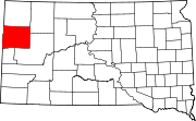
Towns Townships Unorganized
territoriesEast Butte | West Butte
Unincorporated
communitiesCategories:- Butte County, South Dakota
- National Register of Historic Places in South Dakota by county
- Buildings and structures in Butte County, South Dakota
-


Wikimedia Foundation. 2010.