- National Register of Historic Places listings in Custer County, Nebraska
-
 Location of Custer County in Nebraska
This is a list of the National Register of Historic Places listings in Custer County, Nebraska. It is intended to be a complete list of the properties and districts on the National Register of Historic Places in Custer County, Nebraska, United States. The locations of National Register properties and districts for which the latitude and longitude coordinates are included below, may be seen in a Google map.[1]
There are 13 properties and districts listed on the National Register in the county. Another site was once listed but has since been removed.
-
- This National Park Service list is complete through NPS recent listings posted November 10, 2011.[2]
Listings county-wide
[3] Landmark name Image Date listed Location City or town Summary 1 Arrow Hotel 
September 12, 1985 509 S. 9th Ave.
41°24′06″N 99°38′26″W / 41.401667°N 99.640556°WBroken Bow 2 Brenizer Library 
July 3, 2007 430 W. Center Ave.
41°29′04″N 99°45′41″W / 41.484444°N 99.761389°WMerna 3 Broken Bow Carnegie Library 
March 5, 1998 255 S. 10th St.
41°24′12″N 99°38′30″W / 41.403333°N 99.641667°WBroken Bow 4 Broken Bow Commercial Square Historic District 
November 21, 2006 Five blocks in downtown Broken Bow centered around the public square
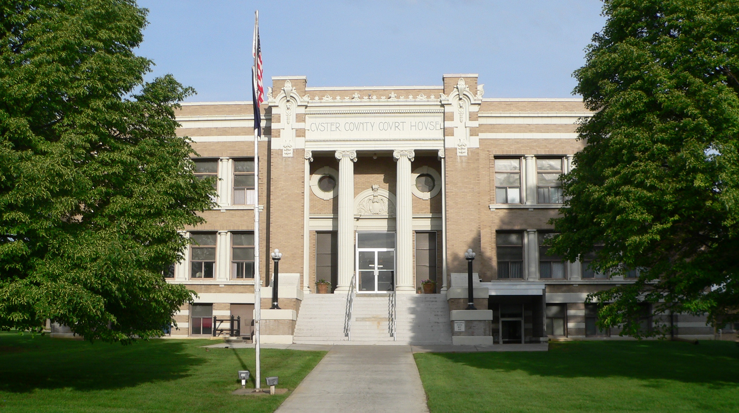
41°24′08″N 99°38′25″W / 41.402222°N 99.640278°WBroken Bow 5 Custer County Courthouse and Jail 
April 19, 1979 Courthouse Square, Main St.
41°24′09″N 99°38′32″W / 41.4025°N 99.642222°WBroken Bow 6 William R. Dowse House 
December 1, 1986 80560 Oak Grove Road[4]
41°30′40″N 99°15′40″W / 41.511111°N 99.261111°WComstock 7 First Custer County Courthouse 
January 10, 1990 Pacific St. and Cameron Ave.
41°17′33″N 99°55′22″W / 41.2925°N 99.922778°WCallaway 8 First National Bank-Steinmeier Building 
August 10, 2011 624 Main St.
41°17′17″N 99°22′53″W / 41.288111°N 99.3815°WAnsley 9 Benjamin and Mary Kellenbarger House 
July 3, 2007 451 W. Center Ave.
41°29′02″N 99°45′51″W / 41.483889°N 99.764167°WMerna 10 Mason City School 
March 2, 2006 750 Main St.
41°13′14″N 99°18′02″W / 41.220556°N 99.300556°WMason City 11 St. Anselm's Catholic Church, Rectory and Parish Hall 
March 12, 2008 Nebraska Highway 2
41°36′58″N 99°51′59″W / 41.616111°N 99.866389°WAnselmo 12 Sargent Bridge 
June 29, 1992 Dawson St. over the Middle Loup River, 1 mile south of Sargent
41°37′38″N 99°22′18″W / 41.627222°N 99.371667°WSargent 13 Security State Bank Building 
November 30, 1987 403 S. 9th St.
41°24′09″N 99°38′26″W / 41.4025°N 99.640556°WBroken Bow Former listing
- Wescott, Gibbons & Bragg Store in Comstock, delisted on March 14, 2007
See also
- List of National Historic Landmarks in Nebraska
- National Register of Historic Places listings in Nebraska
References
- ^ The latitude and longitude information provided in this table was derived originally from the National Register Information System, which has been found to be fairly accurate for about 99% of listings. For about 1% of NRIS original coordinates, experience has shown that one or both coordinates are typos or otherwise extremely far off; some corrections may have been made. A more subtle problem causes many locations to be off by up to 150 yards, depending on location in the country: most NRIS coordinates were derived from tracing out latitude and longitudes off of USGS topographical quadrant maps created under North American Datum of 1927, which differs from the current, highly accurate GPS system used by Google maps. Chicago is about right, but NRIS longitudes in Washington are higher by about 4.5 seconds, and are lower by about 2.0 seconds in Maine. Latitudes differ by about 1.0 second in Florida. Some locations in this table may have been corrected to current GPS standards.
- ^ "National Register of Historic Places: Weekly List Actions". National Park Service, United States Department of the Interior. Retrieved on November 10, 2011.
- ^ Numbers represent an ordering by significant words. Various colorings, defined here, differentiate National Historic Landmark sites and National Register of Historic Places Districts from other NRHP buildings, structures, sites or objects.
- ^ Dowse Riverview Homestead & Dowse Sod House. www.visitnebraska.gov. Retrieved 2010-10-14.
U.S. National Register of Historic Places Topics Lists by states Alabama • Alaska • Arizona • Arkansas • California • Colorado • Connecticut • Delaware • Florida • Georgia • Hawaii • Idaho • Illinois • Indiana • Iowa • Kansas • Kentucky • Louisiana • Maine • Maryland • Massachusetts • Michigan • Minnesota • Mississippi • Missouri • Montana • Nebraska • Nevada • New Hampshire • New Jersey • New Mexico • New York • North Carolina • North Dakota • Ohio • Oklahoma • Oregon • Pennsylvania • Rhode Island • South Carolina • South Dakota • Tennessee • Texas • Utah • Vermont • Virginia • Washington • West Virginia • Wisconsin • WyomingLists by territories Lists by associated states Other  Category:National Register of Historic Places •
  Portal:National Register of Historic Places
Municipalities and communities of Custer County, Nebraska County seat: Broken Bow Cities 
Villages Townships Algernon | Ansley | Arnold | Berwyn | Broken Bow | Cliff | Comstock | Corner | Custer | Delight | Douglas Grove | East Custer | Elim | Elk Creek | Garfield | Grant | Hayes | Kilfoil | Lillian | Loup | Milburn | Myrtle | Ryno | Sargent | Spring Creek | Triumph | Victoria | Wayne | Westerville | West Union | Wood River
Unincorporated
communitiesCategories:- National Register of Historic Places in Nebraska by county
- Custer County, Nebraska
- Buildings and structures in Custer County, Nebraska
-


Wikimedia Foundation. 2010.