- Loup River
Geobox | River
name = Loup River
category = River
image_size =
image_caption =
etymology = French for "wolf", for thePawnee "Wolf People"
country = United States
country_
state = Nebraska
region_type = County
region =
district =
parent =
tributary_left =
tributary_right =
source =
source_location =
source_region = Howard County
source_state = Nebraska
source_elevation_imperial =
source_elevation_note =
source_length_imperial =
source_lat_d = 41
source_lat_m = 16
source_lat_s = 14
source_lat_NS = N
source_long_d = 98
source_long_m = 24
source_long_s = 4
source_long_EW = W
source_coordinates_note = GNIS|830922|Loup River]
mouth =Platte River
mouth_location =
mouth_district =
mouth_region = Platte County
mouth_state = Nebraska
mouth_country =
mouth_note =
mouth_lat_d = 41
mouth_lat_m = 23
mouth_lat_s = 58
mouth_lat_NS = N
mouth_long_d = 97
mouth_long_m = 19
mouth_long_s = 17
mouth_long_EW = W
mouth_coordinates_note =
mouth_elevation_imperial = 1424
mouth_elevation_note =
length_imperial = 68
length_note =
watershed_imperial =
watershed_note =
discharge_location =
discharge_round =
discharge_imperial =
discharge_note =
discharge_min_imperial =
discharge_max_imperial =
discharge1_location =
discharge1_imperial =
discharge1_note =
map_size = 300
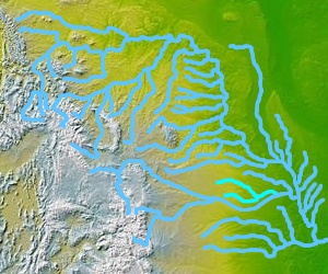
map_caption = The Loup River in Nebraska, showing the North and South Loup rivers
map1 = Nebraska Locator Map.png
map1_caption = Location of the mouth of the Loup River in Nebraska
map1_locator = Nebraska
commons =Loup River (France) ."The Loup River (pronounced /lup/) is a tributary of the
Platte River , approximately convert|68|mi|km long, in centralNebraska in theUnited States . The river drains a sparsely populated rural agricultural area on the eastern edge of theGreat Plains southeast of the Sandhills. The name of the river means "wolf" in French, named by early French trappers after the Skiri or Skidi band of thePawnee , who called themselves the "Wolf People," and lived along its banks. The river and its tributaries, including the North Loup, Middle Loup, and South Loup, are known colloquially as "the Loups", comprising over 1800 mi (2900 km) of streams and draining approximately one-fifth of Nebraska.Course
The river is formed in eastern Howard County, approximately 5 mi (8 km) northeast of St. Paul and 20 mi (32 km) north of Grand Island, by the confluence of the North Loup and Middle Loup rivers. It flows ENE, past Fullerton, where it is joined from the north by the Cedar River. It continues ENE roughly parallel to the Platte, past Genoa, separated from the Platte by approximately 15 mi (24 km). It joins the Platte from the northwest approximately 4 mi (6.4 km) southeast of Columbus.
A diversion dam southwest of Genoa diverts water to the
Loup canal to nearbyhydroelectric facilities in Columbus.ee also
*
List of Nebraska rivers
*French colonization of the Americas
*Mormon Trail References
External links
* [http://www.memoriallibrary.com/NE/Loup/1906/ Trail of the Loup (1906)]

Wikimedia Foundation. 2010.