- National Register of Historic Places listings in Coal County, Oklahoma
-
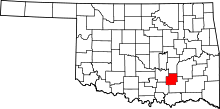 Location of Coal County in Oklahoma
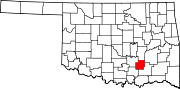
This is a list of the National Register of Historic Places listings in Coal County, Oklahoma.
This is intended to be a complete list of the properties on the National Register of Historic Places in Coal County, Oklahoma, United States. The locations of National Register properties for which the latitude and longitude coordinates are included below, may be seen in a Google map.[1]
There are 5 properties listed on the National Register in the county.
-
- This National Park Service list is complete through NPS recent listings posted November 10, 2011.[2]
Current listings
[3] Landmark name [4] Image Date listed Location City or town Summary 1 Coalgate School Gymnasium-Auditorium September 8, 1988 Fox and Frey Sts.
34°32′01″N 96°13′13″W / 34.533611°N 96.220278°WCoalgate 2 Keel Creek Bridge April 4, 2007 State Highway 31 over Keel Creek
34°36′34″N 96°08′42″W / 34.609444°N 96.145°WCoalgate 3 Merchants National Bank Building December 6, 2006 Southwestern corner of Main and Railway Sts.
34°27′50″N 96°13′29″W / 34.463889°N 96.224722°WLehigh 4 Benjamin Franklin Smallwood House March 10, 1982 West of Lehigh
34°27′44″N 96°16′33″W / 34.462222°N 96.275833°WLehigh 5 United States Post Office Coalgate April 17, 2009 38 N. Main St.
34°32′19″N 96°13′06″W / 34.538611°N 96.218333°WCoalgate See also
- List of National Historic Landmarks in Oklahoma
- National Register of Historic Places listings in Oklahoma
References
- ^ The latitude and longitude information provided in this table was derived originally from the National Register Information System, which has been found to be fairly accurate for about 99% of listings. For about 1% of NRIS original coordinates, experience has shown that one or both coordinates are typos or otherwise extremely far off; some corrections may have been made. A more subtle problem causes many locations to be off by up to 150 yards, depending on location in the country: most NRIS coordinates were derived from tracing out latitude and longitudes off of USGS topographical quadrant maps created under North American Datum of 1927, which differs from the current, highly accurate GPS system used by Google maps. Chicago is about right, but NRIS longitudes in Washington are higher by about 4.5 seconds, and are lower by about 2.0 seconds in Maine. Latitudes differ by about 1.0 second in Florida. Some locations in this table may have been corrected to current GPS standards.
- ^ "National Register of Historic Places: Weekly List Actions". National Park Service, United States Department of the Interior. Retrieved on November 10, 2011.
- ^ Numbers represent an ordering by significant words. Various colorings, defined here, differentiate National Historic Landmark sites and National Register of Historic Places Districts from other NRHP buildings, structures, sites or objects.
- ^ "National Register Information System". National Register of Historic Places. National Park Service. . http://nrhp.focus.nps.gov/natreg/docs/All_Data.html.
U.S. National Register of Historic Places Topics Lists by states Alabama • Alaska • Arizona • Arkansas • California • Colorado • Connecticut • Delaware • Florida • Georgia • Hawaii • Idaho • Illinois • Indiana • Iowa • Kansas • Kentucky • Louisiana • Maine • Maryland • Massachusetts • Michigan • Minnesota • Mississippi • Missouri • Montana • Nebraska • Nevada • New Hampshire • New Jersey • New Mexico • New York • North Carolina • North Dakota • Ohio • Oklahoma • Oregon • Pennsylvania • Rhode Island • South Carolina • South Dakota • Tennessee • Texas • Utah • Vermont • Virginia • Washington • West Virginia • Wisconsin • WyomingLists by territories Lists by associated states Other  Category:National Register of Historic Places •
  Portal:National Register of Historic Places
Municipalities and communities of Coal County, Oklahoma County seat: Coalgate Cities Centrahoma | Coalgate | Lehigh
Towns Unincorporated
communitiesCairo | Clarita | Cottonwood | East Jessie | Olney | Parker
Footnotes ‡This populated place also has portions in an adjacent county or counties
Categories:- Coal County, Oklahoma
- National Register of Historic Places in Oklahoma by county
- Buildings and structures in Coal County, Oklahoma
-

Wikimedia Foundation. 2010.