- National Register of Historic Places listings in Amite County, Mississippi
-
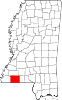
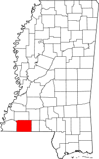 Location of Amite County in Mississippi
This is a list of the National Register of Historic Places listings in Amite County, Mississippi.
This is intended to be a complete list of the properties on the National Register of Historic Places in Amite County, Mississippi, United States. Latitude and longitude coordinates are provided for many National Register properties; these locations may be seen together in a Google map.[1]
There are 18 properties listed on the National Register in the county.
-
- This National Park Service list is complete through NPS recent listings posted November 10, 2011.[2]
Current listings
[3] Landmark name [4] Image Date listed Location City or town Summary 1 Amite County Courthouse 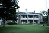
April 9, 1974 Main St.
31°09′27″N 90°48′38″W / 31.1575°N 90.810556°WLiberty 2 Amite Female Seminary April 17, 1980 Mississippi Highway 569
31°09′37″N 90°48′20″W / 31.160278°N 90.805556°WLiberty 3 Thomas Batchelor House March 27, 1975 5 miles east of Liberty of Olio Rd.
31°02′31″N 90°52′53″W / 31.041944°N 90.881389°WLiberty 4 Bethany Institute August 3, 1978 East of Centreville on Mississippi Highway 48
31°05′52″N 90°59′19″W / 31.097778°N 90.988611°WCentreville 5 Bethany Presbyterian Church June 23, 2003 Junction of Mississippi Highway 48 and Perry Rd.
31°06′07″N 90°59′11″W / 31.101944°N 90.986389°WCentreville 6 Decatur N. Butler House May 1, 1984 Off Mississippi Highway 567
31°11′46″N 90°49′54″W / 31.196111°N 90.831667°WLiberty 7 Felder-Richmond House July 12, 1984 Off Interstate 55
31°08′45″N 90°35′34″W / 31.145833°N 90.592778°WMagnolia 8 Hampton Lea House July 12, 1984 Lea Rd.
31°06′18″N 90°36′24″W / 31.105°N 90.606667°WMagnolia 9 Wilford Zachariah Lea House October 25, 1995 Mississippi Highway 569, N., 2 miles north of Liberty
31°10′48″N 90°46′47″W / 31.18°N 90.779722°WLiberty 10 Liberty Presbyterian Church May 16, 1985 North Church St.
31°09′31″N 90°48′33″W / 31.158611°N 90.809167°WLiberty 11 McGehee House November 25, 1983 Southeast of Zion Hill
31°15′04″N 90°47′55″W / 31.251111°N 90.798611°WLiberty 12 Theodore L. McGehee Plantation House March 1, 1996 5924 Tangipahoa Rd.
31°18′38″N 90°34′20″W / 31.310556°N 90.572222°WSummit 13 Pinewood July 5, 1984 South of Liberty off Greensburg Rd.
31°02′14″N 90°48′20″W / 31.037222°N 90.805556°WLiberty 14 Sturdivant Fishweir April 14, 1978 Address Restricted Rosetta 15 Sunnyslope March 22, 1982 Northeast of Centreville
31°06′48″N 91°02′25″W / 31.113333°N 91.040278°WCentreville 16 George Webb House November 17, 1983 East of Old Zion Hill Rd.
31°11′04″N 90°49′31″W / 31.184444°N 90.825278°WLiberty 17 Westbrook Cotton Gin November 10, 2010 395 Gillsburg Rd.
31°09′22″N 90°48′27″W / 31.156111°N 90.8075°WLiberty 18 Winston Wilkinson House April 17, 1980 North of Liberty on Mississippi Highway 567
31°16′22″N 90°51′02″W / 31.272778°N 90.850556°WLiberty See also
- List of National Historic Landmarks in Mississippi
- National Register of Historic Places listings in Mississippi
References
- ^ The latitude and longitude information provided in this table was derived originally from the National Register Information System, which has been found to be fairly accurate for about 99% of listings. For about 1% of NRIS original coordinates, experience has shown that one or both coordinates are typos or otherwise extremely far off; some corrections may have been made. A more subtle problem causes many locations to be off by up to 150 yards, depending on location in the country: most NRIS coordinates were derived from tracing out latitude and longitudes off of USGS topographical quadrant maps created under North American Datum of 1927, which differs from the current, highly accurate GPS system used by Google maps. Chicago is about right, but NRIS longitudes in Washington are higher by about 4.5 seconds, and are lower by about 2.0 seconds in Maine. Latitudes differ by about 1.0 second in Florida. Some locations in this table may have been corrected to current GPS standards.
- ^ "National Register of Historic Places: Weekly List Actions". National Park Service, United States Department of the Interior. Retrieved on November 10, 2011.
- ^ Numbers represent an ordering by significant words. Various colorings, defined here, differentiate National Historic Landmark sites and National Register of Historic Places Districts from other NRHP buildings, structures, sites or objects.
- ^ "National Register Information System". National Register of Historic Places. National Park Service. . http://nrhp.focus.nps.gov/natreg/docs/All_Data.html.
U.S. National Register of Historic Places Topics Lists by states Alabama • Alaska • Arizona • Arkansas • California • Colorado • Connecticut • Delaware • Florida • Georgia • Hawaii • Idaho • Illinois • Indiana • Iowa • Kansas • Kentucky • Louisiana • Maine • Maryland • Massachusetts • Michigan • Minnesota • Mississippi • Missouri • Montana • Nebraska • Nevada • New Hampshire • New Jersey • New Mexico • New York • North Carolina • North Dakota • Ohio • Oklahoma • Oregon • Pennsylvania • Rhode Island • South Carolina • South Dakota • Tennessee • Texas • Utah • Vermont • Virginia • Washington • West Virginia • Wisconsin • WyomingLists by territories Lists by associated states Other  Category:National Register of Historic Places •
  Portal:National Register of Historic Places
Municipalities and communities of Amite County, Mississippi County seat: Liberty Towns Centreville‡ | Crosby‡ | Gloster | Liberty
Communities Footnotes ‡This populated place also has portions in an adjacent county or counties
Categories:- Amite County, Mississippi
- National Register of Historic Places in Mississippi by county
- Buildings and structures in Amite County, Mississippi
-


Wikimedia Foundation. 2010.