- Moses Lake (Texas)
-
Moses Lake Lake Location Galveston Bay, Texas Coordinates 29°34′20″N 95°2′37″W / 29.57222°N 95.04361°WCoordinates: 29°34′20″N 95°2′37″W / 29.57222°N 95.04361°W Primary inflows Moses Bayou Primary outflows Galveston Bay Basin countries United States Surface area 25 square miles (65 km2)
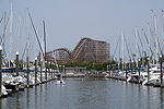
Moses Lake is a lake located near Texas City, Texas, USA in the Houston-Sugar Land-Baytown metropolitan area. It is fed by Moses Bayou and drains into Galveston Bay.References
- Moses Lake from the Handbook of Texas Online. Retrieved 23 Oct 2009. Texas State Historical Association
Notes
Galveston Bay Area HistoryLarge cities 
Other cities Anahuac · Beach City · Clear Lake Shores · Dickinson · El Lago · Deer Park · Friendswood · Kemah · La Marque · La Porte · League City · Nassau Bay · Morgan's Point · Seabrook · Shoreacres · Taylor Lake Village · Texas City · WebsterCDPs and non-
municipalitiesBacliff · Bayview · Clear Lake City (part of Houston/Pasadena) · Double Bayou · San Leon · Smith PointCounties Subregions Bodies of
waterArmand Bayou · Cedar Bayou · Clear Creek · Clear Lake · Dickinson Bay · Galveston Bay · Lake Anahuac · Moses Lake · San Jacinto River · Taylor Lake · Trinity Bay · Trinity RiverMajor ports Barbours Cut · Bayport · Texas CityNature
preservesAnahuac National Wildlife Refuge · Armand Bayou Nature Center · Baytown Nature Center · Pine Gully Park · Texas City Prairie Preserve Houston–Sugar Land–Baytown
Counties Austin • Brazoria • Chambers • Fort Bend • Galveston • Harris • Liberty • Montgomery • San Jacinto • Waller
"Principal" cities Other cities Alvin • Angleton • Bellaire • Clute • Deer Park • Dickinson • Freeport • Friendswood • Galena Park • Humble • Jacinto City • Katy • Lake Jackson • La Marque • La Porte • League City • Missouri City • Pasadena • Pearland • Richmond • Rosenberg • South Houston • Stafford • Texas City • West University Place
- For a complete listing, see list of cities and towns in Houston–Sugar Land–Baytown MSA
Unincorporated
areasAtascocita • Channelview • Cloverleaf • Crosby • Cypress • Fresno • Hockley • Klein • Port Bolivar • Spring • The WoodlandsBodies of water Buffalo Bayou • Galveston Bay • Gulf Intracoastal Waterway • Houston Ship Channel • San Jacinto River • Trinity River • Lake Houston • Lake ConroeCategories:- Geography of Galveston County, Texas
- Geography of Houston, Texas
- Greater Houston
- Galveston Bay Area
- Texas geography stubs
Wikimedia Foundation. 2010.
