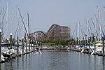
- Dickinson Bay (Texas)
-
Dickinson Bay Location Galveston Bay, Texas, United States Coordinates 29°28′7″N 94°56′45″W / 29.46861°N 94.94583°WCoordinates: 29°28′7″N 94°56′45″W / 29.46861°N 94.94583°W River sources Dickinson Bayou Ocean/sea sources Gulf of Mexico Countries United States Max. length 1 mile (1.6 km) Max. width 1 mile (1.6 km) Settlements San Leon Dickinson Bay is an inlet of Galveston Bay in Texas, United States within the Greater Houston metropolitan area. It is fed by Dickinson Bayou and the community of San Leon sits on a peninsula to its north.
References
- Dickinson Bay from the Handbook of Texas Online
Galveston Bay Area HistoryLarge cities 
Other cities Anahuac · Beach City · Clear Lake Shores · Dickinson · El Lago · Deer Park · Friendswood · Kemah · La Marque · La Porte · League City · Nassau Bay · Morgan's Point · Seabrook · Shoreacres · Taylor Lake Village · Texas City · WebsterCDPs and non-
municipalitiesBacliff · Bayview · Clear Lake City (part of Houston/Pasadena) · Double Bayou · San Leon · Smith PointCounties Subregions Bodies of
waterArmand Bayou · Cedar Bayou · Clear Creek · Clear Lake · Dickinson Bay · Galveston Bay · Lake Anahuac · Moses Lake · San Jacinto River · Taylor Lake · Trinity Bay · Trinity RiverMajor ports Barbours Cut · Bayport · Texas CityNature
preservesAnahuac National Wildlife Refuge · Armand Bayou Nature Center · Baytown Nature Center · Pine Gully Park · Texas City Prairie Preserve Houston–Sugar Land–Baytown
Counties Austin • Brazoria • Chambers • Fort Bend • Galveston • Harris • Liberty • Montgomery • San Jacinto • Waller
"Principal" cities Other cities Alvin • Angleton • Bellaire • Clute • Deer Park • Dickinson • Freeport • Friendswood • Galena Park • Humble • Jacinto City • Katy • Lake Jackson • La Marque • La Porte • League City • Missouri City • Pasadena • Pearland • Richmond • Rosenberg • South Houston • Stafford • Texas City • West University Place
- For a complete listing, see list of cities and towns in Houston–Sugar Land–Baytown MSA
Unincorporated
areasAtascocita • Channelview • Cloverleaf • Crosby • Cypress • Fresno • Hockley • Klein • Port Bolivar • Spring • The WoodlandsBodies of water Buffalo Bayou • Galveston Bay • Gulf Intracoastal Waterway • Houston Ship Channel • San Jacinto River • Trinity River • Lake Houston • Lake ConroeCategories:- Geography of Chambers County, Texas
- Geography of Houston, Texas
- Greater Houston
- Galveston Bay Area
- East Texas geography stubs
Wikimedia Foundation. 2010.
