- Larissa (regional unit)
-
Larissa
Περιφερειακή ενότητα
Λάρισας— Regional unit — Municipalities of Larissa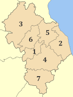 Larissa within Greece
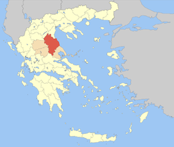
Coordinates: 39°40′N 22°30′E / 39.667°N 22.5°ECoordinates: 39°40′N 22°30′E / 39.667°N 22.5°E Country Greece Region Thessaly Capital Larissa Area – Total 5,381 km2 (2,077.6 sq mi) Population (2005) – Total 282,447 – Density 52.5/km2 (135.9/sq mi) Postal codes 40x xx, 41x xx Area codes 2410, 249x0 ISO 3166 code GR-42 Car plates ΡΙ Larissa (Greek: Περιφερειακή ενότητα Λάρισας) is one of the regional units of Greece. It is part of the region of Thessaly. Its capital is the city of Larissa. (Total population 282,447)
Contents
Geography
Larissa is the second largest regional unit in Greece, exceeded only by Aetolia-Acarnania. It covers about one-third of Thessaly. It borders the regional units of Kozani to the northwest, Pieria to the northeast, the Aegean Sea to the east, Magnesia to the southeast, Phthiotis to the south, Karditsa to the southwest and Trikala to the west.
The tallest mountain in Greece, Mount Olympus (2,917 m) is situated in the northeastern part of the regional unit. Mount Ossa is situated in the east, at the Aegean coast. The lower stretch of the river Pineios flows through the Vale of Tempe, between Olympus and Ossa.
The northern part is covered with forests, but most of the regional unit is fertile land, the Thessalian Plain.
Climate
Larissa has a mainly Mediterranean climate with hot summers and mild winters. Winter is harsher in the mountains areas, notably the north and Mount Olympus. Larissa is often the warmest area in Greece in summer and the coldest in winter. The highest temperature ever recorded was 45.2 °C and the coldest was -21.6 °C.
Administration
The regional unit Larissa is subdivided into 7 municipalities. These are (number as in the map in the infobox):[1]
Prefecture
Larissa was created as a prefecture (Greek: Νομός Λάρισας) in 1882. As a part of the 2011 Kallikratis government reform, the regional unit Larissa was created out of the former prefecture Larissa. The prefecture had the same territory as the present regional unit. At the same time, the municipalities were reorganised, according to the table below.[1]
New municipality Old municipalities Seat Agia Agia Agia Evrymenes Lakereia Melivoia Elassona Elassona Elassona Antichasia Verdikousa Karya Livadi Olympos Potamia Sarantaporo Tsaritsani Farsala Farsala Farsala Enippeas Narthaki Polydamantas Kileler Kileler Nikaia Armenio Krannonas Nikaia Platykampos Larissa (Larisa) Larissa Larissa Giannouli Koilada Tempi Makrychori Makrychori Ampelakia Gonnoi Kato Olympos Nessonas Tyrnavos Tyrnavos Tyrnavos Ampelonas Provinces
- Province of Larissa - Larissa
- Province of Tyrnavos - Tyrnavos
- Province of Agia - Agia
- Province of Elassona - Elassona
- Province of Farsala - Farsala
Note: Provinces no longer hold any legal status in Greece.
History
The area of Larissa was home to the Pelasgians until they merged into the broeader Greek culture. The area was invaded and was ruled by the Kingdom of Macedonia a few centuries later, and was conquered by the Roman Republic after the Third Macedonian War. The Roman imperial period was followed by Byzantine rule, which was in turn succeeded by the Ottoman Empire. Parts of Thessaly revolted during the Greek War of Independence, but Thessaly remained under Ottoman Turkish rule. It was awarded to Greece in the Congress of Berlin in 1878, and finally incorporated into the Hellenic Kingdom in 1881, albeit parts of the modern Larissa prefecture, including Tyrnavos, Elassona and Sarantaporo, remained Ottoman. During the Greco-Turkish War of 1897, the area was successfully invaded by the Ottomans, but in the end Greece conceded only minor territorial losses. The northern portions of the prefecture, the Tempe Valley and Mount Olympus, were not taken by Greece until the First Balkan War in 1912-1913.
The economy increased since the annexation in 1881 and later after 1913 for the north. After the Greco-Turkish War in Asia Minor of 1920-1922, refugees were relocated to the Prefecture. Several villages were created for them across the prefecture. During World War II, the area was a major scene of partisan activity. The occupation and the subsequent Greek Civil War however destroyed most of the local infrastructure. From the 1950s on, the road network was significantly expanded: the GR-1 was opened in 1957 and extended in the 1960s to the Tempe Valley. Electricity and radio service were provided throughout the prefecture, while television arrived in the 1970s. In 1984, the University of Thessaly opened its doors.
Economy
Its main economy since the 1970s are manufacturing, businesses, communications and services. Agriculture is the second leading industry.
Agriculture
The Thessalian Plain is famous for its crops including fruits (watermelon and melon), vegetables (tomatoes, potatoes, cucumbers, onions, etc.), cotton, dairy, cattle and other crops.
Communications
Television
- TRT
- Thessaly
Newspapers
- Agrotikoi Ekfasi - Larissa
- I Alitheia - Farsala
- Eleftheria - Larissa
- I Foni - Farsala
- Imerisia Kyrikas - Larissa
- I Nea tis Farsalou - Farsala
Transport
There are a number of highways E75 and the main railway from Athens to Thessaloniki crosses Thessaly. The region is directly linked to the rest of Europe through International Airport of Central Greece located in Nea Anchialos in a small distance from Larisa (26 kilometers).
- Greek National Road 1/E75, SE, Cen., E - partially a divided superhighway
- Greek National Road 3, S, Cen., NW
- Motorway 3 - future
- Greek National Road 6, W, Cen., SE
- Greek National Road 13, NW
- Greek National Road 26, NW
- Greek National Road 30, S
- Larissa-Karditsa Road, S, SW
- Grevena-Elassona Road, NW
- Larissa-Melivoia Road, S, E
Sports
Sporting clubs include:
- AE Larissa - the only team in Greece that ever won a championship other than the teams from Athens and Thessaloniki.
- Olympia Larissa BC
- AEL 1964 BC
See also
References
Municipality of AgiaMunicipality of ElassonaElassona (seat) • Antichasia • Karya • Livadi • Olympos • Potamia • Sarantaporo • Tsaritsani • VerdikousaMunicipality of FarsalaMunicipality of KilelerMunicipality of LarissaMunicipality of TempiMunicipality of Tyrnavos• LarissaArea: 14,037 km² • Population : 753,888 (2001) • Capital: LarissaRegional unit of Karditsa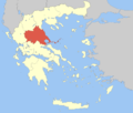 Regional unit of LarissaRegional unit of MagnesiaRegional unit of the SporadesRegional unit of TrikalaRegional governor: Konstantinos Agorastos • Website: http://www.pthes.gov.gr
Prefectures of Greece Achaea and Elis (1833) · Achaea (1899) · Adrianople (1920)‡ · Aetolia-Acarnania (1833) · Arcadia (1833) · Argolis and Corinthia (1833) · Argolis (1899) · Argyrokastron (1915)§ · Arta (1882) · Attica and Boeotia (1833) · Attica (1899) · Boeotia (1899) · Chalkidiki (1915) · Chania (1912) · Chios (1915) · Corfu (1864) · Corinthia (1899) · Cyclades (1833) · Dodecanese (1947) · Drama (1915) · Elis (1899) · Euboea (1833) · Evros (1920) · Evrytania (1899) · Florina (1915) · Grevena (1964) · Heraklion (1912) · Imathia (1947) · Ioannina (1915) · Kallipolis (1920)‡ · Karditsa (1899) · Kastoria (1941) · Kavala (1915) · Kefallinia (1864) · Kilkis (1934) · Korytsa (1915)§ · Kozani (1915) · Lacedaemon (1899) · Laconia (1833) · Lakoniki (1899) · Larissa (1882) · Lasithi (1912) · Lefkada (1864) · Lesbos (1915) · Magnesia (1899) · Messenia (1833) · Pella (1930) · Phocis and Locris (1833) · Phocis (1899) · Phthiotis and Phocis (1845) · Phthiotis (1899) · Pieria (1947) · Piraeus (1964) · Preveza (1915) · Rethymno (1912) · Rhaedestos (1920)‡ · Rhodope (1920) · Samos (1915) · Saranta Ekklisies (1920)‡ · Serres (1915) · Sfakia (1912) · Thesprotia (1937) · Thessaloniki (1914) · Trikala (1882) · Trifylia (1899) · Xanthi (1944) · Zakynthos (1864)
From 1971, Attica Prefecture consisted of four prefecture-level units: Athens, East Attica, Piraeus, West Attica
From 1994, the prefectures of Athens and Piraeus; Drama, Kavala and Xanthi; Rhodope and Evros; were grouped intro super-prefecturesdates of first establishment in parentheses
today outside Greece: § in Northern Epirus ‡ in Eastern ThraceKokkino Nero • Platia Ammos • Stomio BeachRegional unit of Kato OlymposKastri-Loutro • Paralia Koulouras • Nea MesangalaRegional unit of MeliviaAgiokampos • Kato Sotiritsa • Koutsoupia • Paliouria • Rakopotamos • Velika (Spitaki)• LarissaCategories:- Prefectures of Greece
- Larissa Prefecture
- Regional units of Greece


Wikimedia Foundation. 2010.