- Corfu (regional unit)
-
For other uses, see Corfu (disambiguation).
Corfu
Περιφερειακή ενότητα
Κέρκυρας— Peripheral unit — Municipalities of Corfu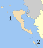 Corfu within Greece
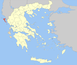
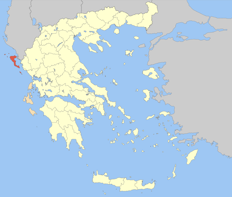
Coordinates: 39°40′N 19°45′E / 39.667°N 19.75°ECoordinates: 39°40′N 19°45′E / 39.667°N 19.75°E Country Greece Periphery Ionian Islands Capital Corfu (city) Government - Vice Governor Christos Skourtis Area - Total 641.057 km2 (247.5 sq mi) Population (2005) - Total 113,658 - Density 177.3/km2 (459.2/sq mi) Postal codes 49x xx Area codes 266x0 ISO 3166 code GR-22 Car plates ΚΥ Website kerkyra.gr Corfu (Greek: Περιφερειακή ενότητα Κέρκυρας) is one of the peripheral units of Greece. It is part of the periphery of Ionian Islands. The capital of the peripheral unit is the town of Corfu. The peripheral unit consists of the islands of Corfu, Paxoi, Othonoi, Ereikoussa, Mathraki and several smaller islands, all in the Ionian Sea.
Contents
Administration
The peripheral unit Corfu is subdivided into 2 municipalities. These are (number as in the map in the infobox):[1]
- Corfu (Kerkyra, 1)
- Paxoi (2)
Prefecture
As a part of the 2011 Kallikratis government reform, the peripheral unit Corfu was created out of the former prefecture Corfu (Greek: Νομός Κέρκυρας). The prefecture, created in 1864, had the same territory as the present peripheral unit. At the same time, the municipalities were reorganised, according to the table below.[1]
New municipality Old municipalities Seat Corfu Corfu (city) Corfu (city) Agios Georgios Achilleio Ereikoussa Esperies Thinali Kassopaia Korissia Lefkimmi Mathraki Meliteieis Othonoi Palaiokastritsa Parelioi Faiakes Paxoi Paxoi Gaios Provinces
The provinces were:
Population
Year Population 1991 105,043 2001 111,975 See also
References
External links
Administrative division of the Ionian Islands Region Area: 2,307 km² • Population : 212,984 (2001) • Capital: Corfu Regional unit of CorfuCorfu • Paxoi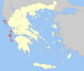 Regional unit of IthacaRegional unit of CephaloniaRegional unit of LefkadaRegional unit of Zakynthos
Regional governor: Spyros Spyrou • Website: www.pin.gov.gr Prefectures of Greece Achaea and Elis (1833) · Achaea (1899) · Adrianople (1920)‡ · Aetolia-Acarnania (1833) · Arcadia (1833) · Argolis and Corinthia (1833) · Argolis (1899) · Argyrokastron (1915)§ · Arta (1882) · Attica and Boeotia (1833) · Attica (1899) · Boeotia (1899) · Chalkidiki (1915) · Chania (1912) · Chios (1915) · Corfu (1864) · Corinthia (1899) · Cyclades (1833) · Dodecanese (1947) · Drama (1915) · Elis (1899) · Euboea (1833) · Evros (1920) · Evrytania (1899) · Florina (1915) · Grevena (1964) · Heraklion (1912) · Imathia (1947) · Ioannina (1915) · Kallipolis (1920)‡ · Karditsa (1899) · Kastoria (1941) · Kavala (1915) · Kefallinia (1864) · Kilkis (1934) · Korytsa (1915)§ · Kozani (1915) · Lacedaemon (1899) · Laconia (1833) · Lakoniki (1899) · Larissa (1882) · Lasithi (1912) · Lefkada (1864) · Lesbos (1915) · Magnesia (1899) · Messenia (1833) · Pella (1930) · Phocis and Locris (1833) · Phocis (1899) · Phthiotis and Phocis (1845) · Phthiotis (1899) · Pieria (1947) · Piraeus (1964) · Preveza (1915) · Rethymno (1912) · Rhaedestos (1920)‡ · Rhodope (1920) · Samos (1915) · Saranta Ekklisies (1920)‡ · Serres (1915) · Sfakia (1912) · Thesprotia (1937) · Thessaloniki (1914) · Trikala (1882) · Trifylia (1899) · Xanthi (1944) · Zakynthos (1864)
From 1971, Attica Prefecture consisted of four prefecture-level units: Athens, East Attica, Piraeus, West Attica
From 1994, the prefectures of Athens and Piraeus; Drama, Kavala and Xanthi; Rhodope and Evros; were grouped intro super-prefecturesdates of first establishment in parentheses
today outside Greece: § in Northern Epirus ‡ in Eastern ThraceCategories:- Corfu Prefecture
- Prefectures of Greece
- Regional units of Greece
- 1864 establishments in Greece


Wikimedia Foundation. 2010.