- Lasithi
Infobox Pref GR
name = Lasithi
name_local = Νομός Λασιθίου
flag_reg =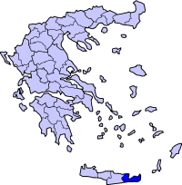
periph =Crete
capital = Agios Nikolaos
population = 77,917
population_as_of = 2005
pop_rank = 41st
pop_dens = 42.7
popdens_rank = 38th
area = 1,823
area_rank = 36th
postal_code = 72x xx
area_code = 284x0
licence = ΑΝ
provinces = 4
municip = 8
commun =
ISO = GR-92
website = [http://www.lassithi.gr www.lassithi.gr]Lasithi (Greek: Λασίθι) is the easternmost prefecture on the island of
Crete , to the east of the prefecture of Heraklion. Its capital is Agios Nikolaos, the other major towns beingIerapetra ,Sitia and Neapoli. The mountains include theDikte to the west and theSitia Mountains to the east. TheSea of Crete lies to the north and theLibyan Sea to the south.To the east of the village of
Elounda lies the island ofSpinalonga , formerly a Venetian fortress and aleper colony . On the foot of Mount Dikti lies theLasithi Plateau , famous for itswindmill s. Vai is well-known for its datepalm forest.Thanks to stunning beaches and its mild climate year-long, Lasithi attracts many tourists. Mass tourism is served by places like Vai, Agios Nikolaos and the island of Chrissi. More off-beat tourism can be found in villages on the south coast like
Myrtos , Makrys Gialos or Makrigialos, Xerokambos andKoutsouras .The prefecture is home to a number of ancient remains.
Vasiliki ,Fournu Korfi ,Pyrgos ,Zakros andGournia are ruins of Minoan date,Lato andItanos were Doric towns.History
The history of Lasthithi can be traced over at least three millennia. [Livingston Vance Watrous, "Lasithi, a History of Settlement on a Highland Plain in Crete", 1982 - 89 pages] The region has considerable ancient history antecedents, including the Dorian era settlement of
Olous andLato . [ [http://themodernantiquarian.com/site/10847/lato.html#fieldnotes C.Michael Hogan, "Lato Fieldnotes", The Modern Antiquarian, Jan 10, 2008] ]Population records
*1991: 70,762, density: 38.82/km²
*2001: 76,318, density: 41.77/km²Transport
*GR-90/
E65 , NW, Cen., E, NE
*GR-99, Cen., SMunicipalities
ee also
*
Ieropotamos River
*List of settlements in the Lasithi prefecture References
External links
* [http://interisk.imbc.gr/reg_crete.html Geographical profile of Lasithi]
Wikimedia Foundation. 2010.