- Chios (regional unit)
-
Chios
Περιφερειακή ενότητα
Χίου— Peripheral unit — Municipalities of Chios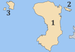 Chios within Greece
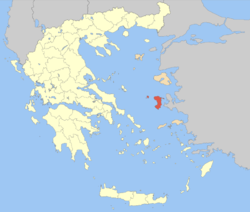
Coordinates: 38°25′N 26°0′E / 38.417°N 26°ECoordinates: 38°25′N 26°0′E / 38.417°N 26°E Country Greece Periphery North Aegean Capital Chios (town) Area - Total 904 km2 (349 sq mi) Population (2005) - Total 53,817 - Density 59.5/km2 (154.2/sq mi) Postal codes 82x xx Area codes 227x0 ISO 3166 code GR-85 Car plates ΧΙ Website chios.gr Chios (Greek: Περιφερειακή ενότητα Χίου) is one of the peripheral units of Greece. It is part of the periphery of North Aegean. The capital of the peripheral unit is the town of Chios. The peripheral unit consists of the islands of Chios, Psara, Oinousses and some smaller uninhabited islands (including Antipsara), all in the Aegean Sea.
Contents
Administration
The peripheral unit Chios is subdivided into 3 municipalities. These are (number as in the map in the infobox):[1]
Prefecture
As a part of the 2011 Kallikratis government reform, the peripheral unit Chios was created out of the former prefecture Chios (Greek: Νομός Χὶου). The prefecture had the same territory as the present peripheral unit. At the same time, the municipalities were reorganised, according to the table below.[1]
New municipality Old municipalities Seat Chios Chios (town) Chios (town) Agios Minas Amani Ionia Kampochora Kardamyla Mastichochoria Omiroupoli Oinousses Oinousses Oinousses Psara Psara Psara See also
External links
- Official Chios website : operated by Chios Prefecture (including tourist guide)
References
Administrative division of the North Aegean Region Area: 3,836km² • Population: 206,121 (2001) • Capital: Mytilini Regional unit of Chios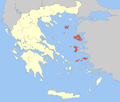 Regional unit of IkariaRegional unit of Lemnos
Regional governor: Athanasios Giakalis • Website: www.pvaigaiou.gov.gr Prefectures of Greece Achaea and Elis (1833) · Achaea (1899) · Adrianople (1920)‡ · Aetolia-Acarnania (1833) · Arcadia (1833) · Argolis and Corinthia (1833) · Argolis (1899) · Argyrokastron (1915)§ · Arta (1882) · Attica and Boeotia (1833) · Attica (1899) · Boeotia (1899) · Chalkidiki (1915) · Chania (1912) · Chios (1915) · Corfu (1864) · Corinthia (1899) · Cyclades (1833) · Dodecanese (1947) · Drama (1915) · Elis (1899) · Euboea (1833) · Evros (1920) · Evrytania (1899) · Florina (1915) · Grevena (1964) · Heraklion (1912) · Imathia (1947) · Ioannina (1915) · Kallipolis (1920)‡ · Karditsa (1899) · Kastoria (1941) · Kavala (1915) · Kefallinia (1864) · Kilkis (1934) · Korytsa (1915)§ · Kozani (1915) · Lacedaemon (1899) · Laconia (1833) · Lakoniki (1899) · Larissa (1882) · Lasithi (1912) · Lefkada (1864) · Lesbos (1915) · Magnesia (1899) · Messenia (1833) · Pella (1930) · Phocis and Locris (1833) · Phocis (1899) · Phthiotis and Phocis (1845) · Phthiotis (1899) · Pieria (1947) · Piraeus (1964) · Preveza (1915) · Rethymno (1912) · Rhaedestos (1920)‡ · Rhodope (1920) · Samos (1915) · Saranta Ekklisies (1920)‡ · Serres (1915) · Sfakia (1912) · Thesprotia (1937) · Thessaloniki (1914) · Trikala (1882) · Trifylia (1899) · Xanthi (1944) · Zakynthos (1864)
From 1971, Attica Prefecture consisted of four prefecture-level units: Athens, East Attica, Piraeus, West Attica
From 1994, the prefectures of Athens and Piraeus; Drama, Kavala and Xanthi; Rhodope and Evros; were grouped intro super-prefecturesdates of first establishment in parentheses
today outside Greece: § in Northern Epirus ‡ in Eastern ThraceCategories:- Chios
- Ionian colonies
- North Aegean islands
- Prefectures of Greece
- Tourism in Greece
- Regional units of Greece
- 1915 establishments in Greece


Wikimedia Foundation. 2010.