- Kilkis (regional unit)
-
Kilkis
Περιφερειακή ενότητα
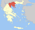
Κιλκίς— Regional unit — Municipalities of Kilkis Kilkis within Greece Coordinates: 41°0′N 22°50′E / 41°N 22.833°ECoordinates: 41°0′N 22°50′E / 41°N 22.833°E Country Greece Region Central Macedonia Capital Kilkis Government - Vice Governor Christos Gountenoudis Area - Total 2,519 km2 (972.6 sq mi) Population (2005) - Total 91,828 - Density 36.5/km2 (94.4/sq mi) Postal codes 61x xx Area codes 234x0 ISO 3166 code GR-57 Car plates ΚΙ Website kilkis.gr Kilkis (Greek: Περιφερειακή ενότητα Κιλκίς) is one of the regional units of Greece. It is part of the region of Central Macedonia. Its capital is the city of Kilkis.
Contents
Geography
The mountains near Kilkis are Paiko (highest peek 1,650 m/5,413 ft) to the west, parts of the western part of Kerkini (at 1,874 m/6,148 ft the highest peek in Kilkis regional unit) to the northeast and Krousia (highest peek 1,179 m/3,868 ft) to the east. Lake Doirani is situated to the north and shares its eastern portion of the lake. Kilkis is bounded by the regional units of Serres to the east, Thessaloniki to the south, Pella to the west and the international border of Greece with the Republic of Macedonia (Gevgelija municipality) to the north.
Climate
The areas that mainly get Mediterranean climate is at the southern portion by the Axios valley. Its climate is mainly continental with cold winters in higher elevations.
History
The area of the modern prefecture were made up of several kingdoms before being invaded by the Macedonians and were later ruled by them. The rule ended after the Third Macedonian War and became a part of the Roman Empire. After the split of the two empires in 395, the area was to be ruled by the Eastern Roman and the Byzantine Empires. At the 10th century AD, the east part of Kilkis Prefecture was handed to Bulgaria and were inhabited by Bulgarians. At the 11th century the area was taken back by the Eastern Roman (Byzantine) Empire. In 1204 was conquared by the Latin Empire of Constantinoupolis and after 60 years returned to the Eastern Roman Empire. The territory of the later prefecture was ruled by the Ottoman Empire for about 500 years. At the end of 19th century the Macedonian Struggle started, when local Greeks and Bulgarians fought in the area. Bulgaria captured the east part of the area in the First Balkan War of 1912. In the Second Balkan War of 1913, the Greek army captured the area, that was finally annexed and became part of Greece. It absorbed many of the Greeks from Northern Macedonia (now the Rep. of Macedonia), especially from Gevgeli, Vogdantsa, Polyane and Stromnitsa.[1] It also absorded many Greeks from Northern Thrace (Bulgaria), that came after the Treaty of Neuilly, and the Bulgarians went to Bulgaria, such that it became a fully Greek speaking area. Finally Kilkis prefecture absorded many of the Greeks from Asia Minor that came to Greece after the Greco Turkish-War of 1922 and with the population exchange prescribed by the Treaty of Lausanne.
Until 1939, when created into a separate prefecture, the area was part of the Thessaloniki prefecture.[2] After World War II and the Greek Civil War, many of its buildings were rebuilt. Its population expanded and several emigrated from the country. The GR-1 was constructed from the late-1960s and opened in 1972 and added two additional lanes in 1973. Its health center in Drosato shut down in 2001.
Transport
- GR-1/E75, old and new, SW, W, NW
- GR-65, S, Cen., N, NE
- road to Doirani and Dojran, in the Republic of Macedonia, N
Administration
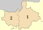
The regional unit Kilkis is subdivided into 2 municipalities. These are (number as in the map in the infobox):[3]
- Paionia (2)
- Kilkis (1)
Prefecture
As a part of the 2011 Kallikratis government reform, the former Kilkis Prefecture (Greek: Νομός Κιλκίς) was transformed into a regional unit within the Central Macedonia region, without any change in boundaries. At the same time, the municipalities were reorganised, according to the table below.[3]
New municipality Old municipalities Seat Kilkis Kilkis Kilkis Gallikos Doirani Kroussa Mouries Pikrolimni Cherso Paionia Axioupoli Polykastro Goumenissa Evropos Livadia Polykastro Provinces
- Province of Kilkis
- Province of Peοnia - Goumenissa
Note: Provinces no longer hold any legal status in Greece.
See also
References
External links
Area: 18,811 km² • Population : 1,874,214 (2001) • Capital: ThessalonikiRegional unit of Chalkidiki Regional unit of ImathiaAlexandreia • Naousa • VeroiaRegional unit of KilkisKilkis • PaioniaRegional unit of PellaRegional unit of PieriaDio-Olympos • Katerini • Pydna–KolindrosRegional unit of SerresRegional unit of ThessalonikiAmpelokipoi–Menemeni • Chalkidona • Delta • Kalamaria • Kordelio–Evosmos • Lagkadas • Neapoli–Sykies • Oraiokastro • Pavlos Melas • Pylaia–Chortiatis • Thermaikos • Thermi • Thessaloniki • VolviRegional governor: Panagiotis Psomiadis (el) • Website: www.pkm.gov.gr
Prefectures of Greece Achaea and Elis (1833) · Achaea (1899) · Adrianople (1920)‡ · Aetolia-Acarnania (1833) · Arcadia (1833) · Argolis and Corinthia (1833) · Argolis (1899) · Argyrokastron (1915)§ · Arta (1882) · Attica and Boeotia (1833) · Attica (1899) · Boeotia (1899) · Chalkidiki (1915) · Chania (1912) · Chios (1915) · Corfu (1864) · Corinthia (1899) · Cyclades (1833) · Dodecanese (1947) · Drama (1915) · Elis (1899) · Euboea (1833) · Evros (1920) · Evrytania (1899) · Florina (1915) · Grevena (1964) · Heraklion (1912) · Imathia (1947) · Ioannina (1915) · Kallipolis (1920)‡ · Karditsa (1899) · Kastoria (1941) · Kavala (1915) · Kefallinia (1864) · Kilkis (1934) · Korytsa (1915)§ · Kozani (1915) · Lacedaemon (1899) · Laconia (1833) · Lakoniki (1899) · Larissa (1882) · Lasithi (1912) · Lefkada (1864) · Lesbos (1915) · Magnesia (1899) · Messenia (1833) · Pella (1930) · Phocis and Locris (1833) · Phocis (1899) · Phthiotis and Phocis (1845) · Phthiotis (1899) · Pieria (1947) · Piraeus (1964) · Preveza (1915) · Rethymno (1912) · Rhaedestos (1920)‡ · Rhodope (1920) · Samos (1915) · Saranta Ekklisies (1920)‡ · Serres (1915) · Sfakia (1912) · Thesprotia (1937) · Thessaloniki (1914) · Trikala (1882) · Trifylia (1899) · Xanthi (1944) · Zakynthos (1864)
From 1971, Attica Prefecture consisted of four prefecture-level units: Athens, East Attica, Piraeus, West Attica
From 1994, the prefectures of Athens and Piraeus; Drama, Kavala and Xanthi; Rhodope and Evros; were grouped intro super-prefecturesdates of first establishment in parentheses
today outside Greece: § in Northern Epirus ‡ in Eastern ThraceCategories:- Kilkis Prefecture
- Prefectures of Greece
- Regional units of Greece
Wikimedia Foundation. 2010.


