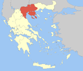
- Nea Zichni
-
Nea Zichni
Νέα Ζίχνη
Location Coordinates 41°2′N 23°50′E / 41.033°N 23.833°ECoordinates: 41°2′N 23°50′E / 41.033°N 23.833°E Government Country: Greece Region: Central Macedonia Regional unit: Serres Mayor: Dairetzis Andreas
(since: 07 November 2010, first election 22 October 2006)Population statistics (as of 2001) Municipality - Population: 15,073 - Area: 405.6 km2 (157 sq mi) - Density: 37 /km2 (96 /sq mi) Municipal unit - Population: 10,952 Community - Population: 2,421 Other Time zone: EET/EEST (UTC+2/3) Elevation (center): 260 m (853 ft) Postal: 62042 Auto: ΕΡ Nea Zichni (Greek: Νέα Ζίχνη, Bulgarian: Зиляхово, Zilyahovo,[1][2][3] Turkish: Zihne[4]) is a municipality in the Serres peripheral unit, of Central Macedonia periphery, Greece. Population 15,073 (2001). Nea Zichni is also the name of the administrative seat of the municipality. Population 2,421 (2001).
Contents
History
The city was originally built next to the marches of Lake Achinos, and it was called Ichna (Greek: Ίχνα). It was a Paionian city, that was sometime in the 5th cBC or early 4th cBC incorporated into the Macedonian Kingdom. Another city by the same name Ichna is mentioned by Thucidides being next to Pella, by the Loudias and Axios Delta. The name Ichna (Greek: Ίχνα) is a Paionian cognate of the Greek word "ichnos" (Greek: ίχνος) which means "stepping ground" a name appropriate for a city built on the sand between the marsh and the lake (or rhw sea).[5] The original Ichna remained a city throughout the Hellenistic Roman and Byzantine eras, only to be destroyed and was rebuilt far from the lake in its original position on the hills. During the ottoman years it was a kaza centre in Serez sanjak of Selanik Province at Ottoman Empire before Balkan Wars as "Zihne".[6]
Municipality
The municipality Nea Zichni was formed at the 2011 local government reform by the merger of the following 2 former municipalities, that became municipal units:[7]
- Alistrati
- Nea Zichni
Gallery
External links
References
- ^ Ethnographie des Vilayets d'Andrinople, de Monastir et de Salonique, 1878, reprint in Bulgarian: „Македония и Одринско. Статистика на населението от 1873 г.“ Македонски научен институт, София, 1995, стр. 146 - 147.
- ^ Кънчов, Васил. „Македония. Етнография и статистика“. София, 1900, стр.181.
- ^ Brancoff, D.M. "La Macédoine et sa Population Chrétienne". Paris, 1905, рр. 202-203.
- ^ http://www.hbvdergisi.gazi.edu.tr/ui/dergiler/makale8.pdf
- ^ Miltiades E. Bolaris: "Macedonian names and makeDONSKI pseudo-linguistics: The case of the name Pella" [1]
- ^ http://muhacirin.blogcu.com/su-albumden-selanik-hatiralari-ekleyen-selanik-selanik-vilayet/7614320 Administrative Division of Selanik Province (Turkish)
- ^ Kallikratis law Greece Ministry of Interior (Greek)
Area: 18,811 km² • Population : 1,874,214 (2001) • Capital: Thessaloniki  Regional unit of ImathiaKilkis • PaioniaRegional unit of PellaRegional unit of PieriaRegional unit of SerresRegional unit of ThessalonikiAmpelokipoi–Menemeni • Chalkidona • Delta • Kalamaria • Kordelio–Evosmos • Lagkadas • Neapoli–Sykies • Oraiokastro • Pavlos Melas • Pylaia–Chortiatis • Thermaikos • Thermi • Thessaloniki • Volvi
Regional governor: Panagiotis Psomiadis (el) • Website: www.pkm.gov.gr Categories:- Municipalities of Central Macedonia
- Populated places in Serres (peripheral unit)
- Central Macedonia geography stubs
Wikimedia Foundation. 2010.


