- Oinousses
-
Oinousses
Οινούσσες
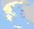
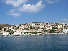
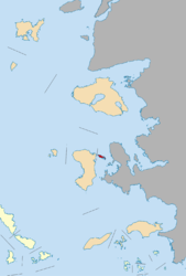
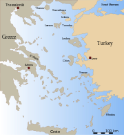
Oinousses main settlementLocation Coordinates 38°31′N 26°13′E / 38.517°N 26.217°ECoordinates: 38°31′N 26°13′E / 38.517°N 26.217°E Government Country: Greece Region: North Aegean Regional unit: Chios Population statistics (as of 2001) Municipality - Population: 1,050 - Area: 17.427 km2 (7 sq mi) - Density: 60 /km2 (156 /sq mi) Other Time zone: EET/EEST (UTC+2/3) Postal: 821 01 Telephone: 22710 Auto: ΧΙ Oinousses (Greek: Οινούσσες), alternative forms: Aignoussa (Αιγνούσα) or Egnoussa(Εγνούσα) is a barren cluster of 1 larger and 8 smaller islands some 2 km off the north-east coast of the Greek island of Chios and 8 km west of Turkey. Administratively the islands form a municipality within the Chios peripheral unit, which is part of the North Aegean Periphery. The principal town of the islands and seat of the municipality is also called Oinousses.[1] Oinousses has a small resident population, living primarily in the islands' town of Oinoússes (pop. 999), and a recently built monastery. The town is centred around a square (plateia) and a small port; it includes a school, several churches, a Naval high school and a maritime museum. The only other populated settlements are Kástron (pop. 32) and Aspalathrókampos (19).
The vast majority of the workforce of the island is engaged in seafaring, fishing and goat-herding.
The islands are noted as the origin of an unusual cluster of successful ship-owning families: the Lemos, Pateras, Hadjipateras, Kollakis and Lyras families. Whilst most of the families now live elsewhere most of the year, the islands and town are well maintained with a strong naval connection. Oinoussians abroad are noted for their successful entrepreneurial skills in the industrial transportation industry. Although the number of Oinoussian ship operating companies has fallen since their heyday in the 1960s they still maintain a formidable position in the industrial transportation industry.
Old maps have also show the islands under the name of Spalmadores, while the Ottomans referred to them as Kujun-Adassi.[citation needed]
Historical population
Year Population 1981 705 1991 636 2001 1,050 See also
- Battle of the Oinousses Islands in 1695 between the Ottoman Empire and the Republic of Venice
- List of settlements in the Chios prefecture
References
- ^ Kallikratis law Greece Ministry of Interior (Greek)
Articles on the Aegean Sea GeneralCountries Other Cyclades Amorgos · Anafi · Andros · Antimilos · Antiparos · Delos · Despotiko · Donoussa · Folegandros · Gyaros · Ios · Irakleia · Kardiotissa · Kea · Keros · Kimolos · Koufonisia · Kythnos · Milos · Mykonos · Nata · Naxos · Paros · Polyaigos · Rineia · Santorini · Schoinoussa · Serifopoula · Serifos · Sifnos · Sikinos · Syros · Therasia · Tinos · VousDodecanese Agathonisi · Arkoi · Armathia · Alimia · Astakida · Astypalaia · Çatalada · Chalki · Chamili · Farmakonisi · Gaidaros · Gyali · Imia/Kardak · Kalolimnos · Kalymnos · Kandelioussa · Kara Ada · Karpathos · Kasos · Kinaros · Kos · Küçük Tavşan Adası · Leros · Lipsi · Lebynthos · Nimos · Nisyros · Patmos · Pacheia · Platy · Pserimos · Rhodes · Saria · Salih Ada · Symi · Syrna · Telendos · Tilos · ZaforaNorth Aegean Agios Eustratius · Ammouliani · Ayvalık Islands · Büyük Ada · Chios · Chryse · Cunda · Foça Islands · Fournoi Korseon · Icaria · Imbros · Koukonesi · Lemnos · Lesbos · Metalik Ada · Nissiopi · Oinousses · Psara · Samiopoula · Samos · Samothrace · Tenedos · Thasos · ThymainaSaronic Sporades Adelfoi Islets · Agios Georgios Skopelou · Alonnisos · Argos Skiathou · Dasia · Erinia · Gioura · Grammeza · Kyra Panagia · Lekhoussa · Peristera · Piperi · Psathoura · Repio · Rineia Skyrou · Sarakino · Skandili · Skantzoura · Skiathos · Skopelos · Skyropoula · Skyros · Tsougria · ValaxaCretan Afendis Christos · Agia Varvara · Agioi Apostoloi · Agioi Pandes · Agioi Theodoroi · Agios Nikolaos · Anavatis · Arnaouti · Aspros Volakas · Avgo · Crete · Daskaleia · Dia · Diapori · Dionysades · Elasa · Ftena Trachylia · Glaronisi · Gramvousa · Grandes · Kalydon (Spinalonga) · Karavi · Karga · Katergo · Kavallos · Kefali · Kolokythas · Koursaroi · Kyriamadi · Lazaretta · Leon · Mavros · Mavros Volakas · Megatzedes · Mochlos · Nikolos · Palaiosouda · Peristeri · Peristerovrachoi · Petalida · Petalouda · Pontikaki · Pontikonisi · Praso Kissamou · Prosfora · Pseira · Sideros · Souda · Valenti · VryonisiOther Aegean Islands Central Aegean Sea Thracian Sea Administrative division of the North Aegean Region Area: 3,836km² • Population: 206,121 (2001) • Capital: MytiliniRegional unit of Chios Regional unit of IkariaRegional unit of LemnosAgios Efstratios • LemnosRegional unit of LesbosRegional unit of SamosRegional governor: Athanasios Giakalis • Website: www.pvaigaiou.gov.grCategories:
- Populated places in Chios (peripheral unit)
- Mediterranean port cities and towns in Greece
- Islands of Greece
- Municipalities of the North Aegean
- North Aegean islands
- Tourism in Greece
- Greece geography stubs
Wikimedia Foundation. 2010.


