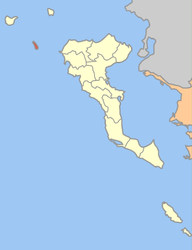
- Mathraki
-
Mathraki
ΜαθράκιLocation Coordinates 39°46′N 19°31′E / 39.767°N 19.517°ECoordinates: 39°46′N 19°31′E / 39.767°N 19.517°E Government Country: Greece Region: Ionian Islands Regional unit: Corfu Municipality: Corfu Population statistics (as of 2001) Municipal unit - Population: 297 - Area: 3.532 km2 (1 sq mi) - Density: 84 /km2 (218 /sq mi) Other Time zone: EET/EEST (UTC+2/3) Elevation: 152 m (499 ft) Postal: 491 00 Telephone: 26630 Auto: ΚΥ Website mathraki.corfumail.gr Mathraki (Greek: Μαθράκι, older form: Μαθράκιον) is an island and a former community of the Ionian Islands, Greece. Since the 2011 local government reform it is part of the municipality Corfu, of which it is a municipal unit.[1] Population 297 (2001). Mathraki is a 45 minute boat ride off the coast of Corfu (4 NM from Cape Arilas). It has three restaurants that double as general stores, villas and "rooms to let". Mathraki is a quiet island that manages to stay clear of tourists except for the occasional hikers that brave the rocky coastline. While the population on the record is high, inclement weather prevents all but 19 villagers from staying on the island year round many of them to the United States. Communally it includes three nearby islets including Diakopo, Diaplo and Tracheia.
References
- ^ Kallikratis law Greece Ministry of Interior (Greek)
External links
- Official site from Local Authority Official site from Mathraki Local Authority (Languages Greek-English-Italian
- Official site from Prefecture of Corfu Official site from Prefecture of Corfu (multi language)
Ionian Islands Main Islands Smaller islands and islets Antikythera · Antipaxi · Arkoudi · Atokos · Drakonera · Elafonisos · Ereikoussa · Kalamos · Kastos · Kravia · Kythros · Lazaretto · Makri · Makropoula · Mathraki · Meganisi · Modia Islets · Othonoi · Oxeia · Petalas · Pistros · Pontikos · Provati · Skorpios · Sparti Lefkados · Strofades · Vidos · Vromonas ·
Municipal unit of Achilleio Agioi Deka · Agios Prokopios · Ano Garouna · Benitses · Gastouri · Kalafationes · Kamara · Kastellanoi · Kato Garouna · Kouramades · Kynopiastes · Stavros · Varypatades · VirosMunicipal unit of Agios Georgios Afionas · Agios Athanasios · Agros · Arkadades · Armenades · Chorepiskopoi · Dafni · Drosato · Kastelannoi · Kavvadades · Mesaria · Pagoi · RachtadesMunicipal unit of Corfu (city) Municipal unit of Ereikoussa Municipal unit of Esperies Municipal unit of Faiakes Agios Markos · Ano Korakiana · Kato Korakiana · Sgourades · Sokraki · Spartylas · ZygosMunicipal unit of Kassopaia Municipal unit of Korissia Municipal unit of Lefkimmi Municipal unit of Mathraki MathrakiMunicipal unit of Meliteieis Agios Matthaios · Ano Pavliana · Chlomatiana · Chlomos · Kato Pavliana · Moraitika · Pentati · Strongyli · VouniatadesMunicipal unit of Othonoi Municipal unit of Palaiokastritsa Municipal unit of Parelioi Municipal unit of Thinali Categories:- Ionian Islands geography stubs
- Populated places in Corfu (peripheral unit)
- Ports and harbours of Greece
- Islands of Greece
- Ionian Islands
Wikimedia Foundation. 2010.


