- Magnesia (regional unit)
-
This article is about the region of Greece. For other meanings, see Magnesia (disambiguation).
Magnesia
Περιφερειακή ενότητα
Μαγνησίας— Peripheral unit — Municipalities of Magnesia and the Sporades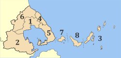 Magnesia within Greece
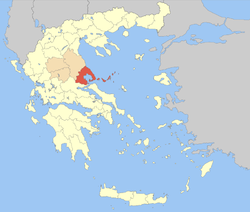
Coordinates: 39°25′N 22°50′E / 39.417°N 22.833°ECoordinates: 39°25′N 22°50′E / 39.417°N 22.833°E Country Greece Periphery Thessaly Capital Volos Area - Total 2,367 km2 (913.9 sq mi) Population (2001) - Total 193,439 - Density 81.7/km2 (211.7/sq mi) Postal codes 37x xx, 38x xx Area codes 242x0 ISO 3166 code GR-43 Car plates ΒΟ Website magnesia.gr Magnesia (Greek: Μαγνησία, Magnisía, IPA: [maɣniˈsia]), deriving from the tribe name Magnetes, is one of the peripheral units of Greece. It is part of the periphery of Thessaly. Its capital is the city of Volos. About 70% of the population of Magnesia live in the Greater Volos area, which is the second-largest city in Thessaly and the third busiest commercial port in Greece. According to the most recent census (2001), the population stands at 207,000. The prefecture hosts 2,000,000 tourists annually.[1] Magnesia is represented in the Greek Parliament by five members. It main agricultural products are tomatoes, cotton, wheats, olives, olive oil and dried nuts, especially almonds and pistachios.
Contents
Geography
A prominent geographic feature of Magnesia is the Pagasetic Gulf, a bay of the Aegean Sea. The Pelion mountain range closes off the Gulf on the east and south side, leaving only a narrow channel near Trikeri. The highest peak of the wooded Pelion is Pourianos Stavros or Xeforti, (altitude 1,624 metres or 5,328 feet). On the south edge of Magnesia peninsula Tisaio mountain is found.
Mt. Maurovouni (1,054 metres or 3,458 feet) is the northeastly most mountain of the prefecture and extends to the neighboring prefecture of Larissa. The southwest border of Magnesia is formed by the Othrys, with its highest peak Gerakovouni (1,726 metres or 5,663 feet). The interior of Magnesia has two plains. The plains southwest of the Pagasetic Gulf arecalled Almyros plains, while the plains northwest of the Gulf are called the Volos-Velestino plain. The hydrological network of Magnesia is not particularly rich and is characterized by the absence of big rivers. The waters coming from Pelion shape the rivers Anavros, Platanorema, and Xirias.
In the North section of the prefecture, Lake Karla was formerly found. Lake Karla was drained in 1962, but attempts have been made for its partial restoration. On the bight of Sourpi, next to Amaliapolis a coastal wetland is located, with various species of migratory birds. This wetland together with the forest of Kouri - an infrequent lowland of Oak tree forest close to Almyros - is included in the list of the protected regions of the European Network Natura 2000.
Climate
 Promenande of Volos
The average temperature is 17 degrees Celsius and the average rainfall about 540 millimetres per year. Heat waves and intense cold periods are rare. During the summer the temperature rises up to about 37 to 38 °C (99 to 100 °F) in August. The climate varies in different parts of the prefecture; close to the Pagasetic Gulf conditions are humid, in Nea Ionia it is quite dry and in Velestino and Almyros is the climate is continental. In winter there is significant snowfall in the mountains and often freezing temperatures.
Administration
The peripheral unit Magnesia is subdivided into 5 municipalities. These are (number as in the map in the infobox):[2]
Prefecture
Magnesia was created as a prefecture. In addition to the territory of the present peripheral unit of Magnesia, the Magnesia Prefecture included the Northern Sporades group of islands (Skiathos, Skopelos and Alonnisos). As a part of the 2011 Kallikratis government reform, the prefecture was split into the Magnesia and Sporades peripheral units. At the same time, the municipalities were reorganised, according to the table below.[2]
New municipality Old municipalities Seat Almyros Almyros Almyros Anavra Pteleos Sourpi Rigas Feraios Feres Velestino Karla Keramidi South Pelion
(Notio Pilio)Argalasti Argalasti Afetes Milies Sipiada Trikeri Volos Volos Volos Agria Aisonia Artemida Iolkos Makrinitsa Nea Anchialos Nea Ionia Portaria Zagora-Mouresi Zagora Zagora Mouresi Provinces
Note: Provinces no longer hold any legal status in Greece.
History
Antiquity
According to Hesiod's (probably) "Eoiae" (Greek: Ηοίαι) or "Catalogue of Women"[3] on the origin of the Greeks, Pandora (named after her grandmother Pandora, sister of Hellen and daughter of Deukalion and Pyrrha) together with Zeus had one son Graecus, while Zeus had two more with Thyia, another of Deukalion's daughter: Magnes and Macedon. Magnes and Makednos together with Hellen's three sons Dorus, Xuthus (with his sons Ion and Achaeus) and Aeolos, comprised the set of progenitors of the ancient tribes that formed the Greek/Hellenic nation. Magnes ruled the area and people under his name. Magnesia is also homeland of the mythical heroes Jason, Peleus and his son Achilles.
The word magnet comes from the Greek "magnítis líthos" (μαγνήτης λίθος), which means "magnesian stone". The names for the elements magnesium and manganese are also derived from this region, which in addition to the magnetic magnetite (an iron ore), produces certain ores of magnesium and manganese that were known to alchemists. The Magnetes contributed to the Greek colonization, with their main colonies being established before the 7th century BC, under the names of Magnesia beside Sipylus in Lydia and Magnesia on the Maeander in Ionia.
Christian era
Written accounts and remains from the 5th century AD document the appearance of Christianity in Magnesia. The minutes of the 3rd Ecumenical Conference are co-signed by the Bishop of Dimitriada Cleonikos. Five basilicas have been revealed in Nea Anhialos, showing that the area was undergoing a spiritual growth in that era. Magnesias has churches, monasteries and chapels, many of which are architectural masterpieces in the style that is called "Pelioritica".
In the area of Pelion are the monastery of Saint Yerasimos in Makrinitsa, The Holy Archangels in Agios Georgios Nilias, Osios Lavredios in Agios Lavrendis, Saint John the Baptist in Siki and Saint Spiridon in Promiri. The most famous is the Monastery in Flamouri, built in the 16th century by Osios Simeon, the so-called "barefoot and loin-clothed", located above Veneto.
In the Almiros area and on the mountain of Othris two other monasteries were built, one inhabited by monks in Ano Pagania (Virgin Mary) Xenia and the other by nuns in Kato Panagia Xenia. This monastery holds historical monuments of the area from the 12th century, with of frescoes, treasuries and a library. In Kato Panagia Xenia monastery, an icon of the Virgin Mary, venerated by the people of the area, is kept. All the monasteries are of archeological, historical and artistic interest and are accessible (the one in Flamouri only by men).
Archaeological sites
- Pagasae
- Iolcus
- Demetrias
- Nea Anchialos
- Mikrothives
Communications
Transport
The prefecture was linked to the National railway (ΟΣΕ) in the late-19th century. In 1964, the GR-1 North-South superhighway was opened to traffic. The prefecture is directly linked to the rest of Europe through International Airport of Central Greece, located in Nea Anchialos, a short distance from Volos. The airport includes a terminal which can serve 1500 passengers per hour.
The prefecture's roads include:
- Greek National Road 1/E75, SW, W, NW
- Greek National Road 6, Cen., NW
- Greek National Road 30, W, Cen.
Persons
- Jason, ancient hero
- Peleus, ancient hero
- Saint Charalampe, (89-202) Eastern Orthodox Church Saint
- Rigas Feraios, the first Greek revolutionary and poet, national hero
- Giorgio de Chirico, (1888–1978)
- Anthimos Gazis, (died 1828)
- Alexandros Papadiamantis, (1851)-(1911)
- Theophilos, artist, (1871)-(1934)
- Sofia Vembo, (1910–1978), musician, artist
- Tzimis Armaos, (Volos--Athens1999), world champion wrestler
- Vangelis, composer, born 1943
- Phaidon Gizikis (June 13, 1917 - July 17, 1999 in Athens), Greek politician
- Lavrentis Machairitsas, composer, musician
- Paraskevi Tsiamita, 1st World Champion 1999, Seville, Spain, triple jump
- Olga Vasdeki, 3rd World Champion 1999, Seville, Spain, triple jump
- Vasilis Polimeros, 3rd Olympic Champion 2004, Athens Greece, sculling
- Nikos Skiathitis, 3rd Olympic Champion 2004, Athens Greece, sculling
- Lavrentis Dianellos, a Greek actor
See also
- List of traditional Greek place names
- List of settlements in the Magnesia prefecture
References
- ^ ANEM Tourist authority of Magnesia
- ^ a b Kallikratis reform law textPDF
- ^ Hesiod (probably), "Eoiae" (Greek: Ηοίαι) or "Catalogue of Women", c.650 BC.
External links
 "Magnesia". Catholic Encyclopedia. New York: Robert Appleton Company. 1913.
Area: 14,037 km² • Population : 753,888 (2001) • Capital: Larissa Regional unit of Karditsa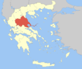 Regional unit of LarissaRegional unit of MagnesiaRegional unit of the SporadesRegional unit of Trikala
Regional governor: Konstantinos Agorastos • Website: http://www.pthes.gov.gr Categories:- Magnesia
- Regional units of Greece
- 2011 establishments in Greece


Wikimedia Foundation. 2010.