- Sarantaporo
-
For a river in Thessaly, see Sarantaporos River (Larissa).
Sarantaporo
ΣαραντάποροLocation 
 Sarantaporo
Coordinates 40°4′N 22°3′E / 40.067°N 22.05°ECoordinates: 40°4′N 22°3′E / 40.067°N 22.05°E Location within the regional unit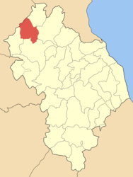
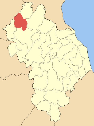
Government Country: Greece Region: Thessaly Regional unit: Larissa Municipality: Elassona Population statistics (as of 2001) Municipal unit - Population: 3,588 Other Time zone: EET/EEST (UTC+2/3) Postal: 402 00 Auto: ΡΙ Sarantaporo (Greek: Σαραντάπορο) is a village and a former municipality in the Larissa regional unit, Thessaly, Greece. Since the 2011 local government reform it is part of the municipality Elassona, of which it is a municipal unit.[1] Population 3,588 (2001). The town is near the mountain ranges of Kamvounio to the northwest and the Pieria mountains to the northeast. Sarantaporo is next to the GR-3 (Larissa - Kozani - Niki). Sarantaporo is located west-southwest of Katerini, northwest of Elassona, Tyrnavos and Larissa, east of Grevena and south-southeast of Kozani. The 40th parallel North is about 5 km south of Sarantaporo.
Contents
Subdivisions
The municipal unit Sarantaporo is subdivided into the following communities (constituent villages in brackets):
- Azoros (Vouvala)
- Gerania
- Giannota
- Lykoudi (Lykoudi, Sykia)
- Milea
- Sarantaporo
- Tsapournia (Tsapournia, Farmaki)
Population
Year Town population Municipality population 1981 817 - 1991 938 - 2001 907 3,588 Geography
The municipality is smade up of mountains covering the area with forests as well as grasslands. Farmlands dominate the valley area and around the village especially the western and the central parts.
Information
The village was originally a Slavic settlement founded under the name Glikovo. Unlike the rest of Thessaly, Sarantaporo did not join Greece until the Balkan Wars where the town was liberated from the Ottoman Turkish yoke which dominated for over 550 years on October 1912 during the Battle of Sarantaporo which saw Greek victory in the First Balkan War. Sarantaporo finally became a part of Greece in 1913 which finished the oppressive Turkish rule. The Sarantaporo Gorge was the strategic location for the battle. The village's name during the Ottoman rule was Glikovon (Γκλίκοβον). Sarantaporo became a municipality in 1994; one of the first to be created under the Capodistrian Law. The area features archaeological findings dating back to the pre-Classical years up to the Ottoman rule.
External links
- Sarantaporo (municipality) on GTP Travel Pages
- Sarantaporo (village) on GTP Travel Pages
- Sarantaporo's Homepage
References
- ^ Kallikratis law Greece Ministry of Interior (Greek)
Municipal unit of Antichasia Akri · Kranea · LoutroMunicipal unit of Elassona Drymos · Elassona · Evangelismos · Galanovrysi · Kefalovryso · Palaiokastro · Stefanovouno · ValanidaMunicipal unit of Karya Municipal unit of Livadi Dolichi · LivadiMunicipal unit of Olympos Municipal unit of Potamia Amourio · Domeniko · Magoula · Mega Eleftherochori · Mesochori · Praitori · Sykea · VlachogiannioMunicipal unit of Sarantaporo Municipal unit of Tsaritsani Municipal unit of Verdikousa Municipality of AgiaMunicipality of ElassonaElassona (seat) • Antichasia • Karya • Livadi • Olympos • Potamia • Sarantaporo • Tsaritsani • VerdikousaMunicipality of FarsalaMunicipality of KilelerMunicipality of LarissaMunicipality of TempiMunicipality of Tyrnavos• Larissa Categories:- Populated places in Larissa (peripheral unit)

Wikimedia Foundation. 2010.