- Coronado State Monument
-
Kuaua Ruin
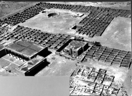
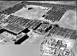 Aerial view of Kuaua ruins, circa 1940

Location: Sandoval County, New Mexico, USA Nearest city: Bernalillo, New Mexico Coordinates: 35°19′46″N 106°33′27″W / 35.32944°N 106.5575°WCoordinates: 35°19′46″N 106°33′27″W / 35.32944°N 106.5575°W Built: 1939 Architect: John Gaw Meem Architectural style: Pueblo Governing body: State NRHP Reference#: 76001199[1] Added to NRHP: January 1, 1976 Coronado, New Mexico's first state monument to open to the public, was dedicated on May 29, 1940, as part of the Cuarto Centenario commemoration (400th Anniversary) of Francisco Vasquez de Coronado's entry into New Mexico. It is located along New Mexico Highway 44, 1 mile west of Bermalillo and 16 miles north of Albuquerque. [2]
Although it is named for Vasquez de Coronado, who camped in the vicinity in 1540–1542, this archeological site is most noted for the ruins of Kuaua pueblo. The pueblo or village was settled about 1300 and abandoned toward the end of the 16th century. Kuaua was one of several Tiwa-speaking pueblos in the area when the conquistador Vasquez de Coronado arrived, and the village was almost certainly abandoned due to the after effects of the Tiguex War (February 1541).
The ruins of Kuaua Pueblo were excavated in the 1930s by an archeological team led by Edgar Lee Hewett and Marjorie F. Tichy (Lambert). The excavation revealed a south-to-north development over the village's three centuries of existence, as well as six kivas built in round, square and rectangular shapes. The site is particularly noted for a series of pre-contact (pre-1492) murals that were recovered from a square kiva in the pueblo's south plaza. These murals represent one of the finest examples of pre-contact Native American art to be found anywhere in North America. Fifteen of the restored murals are displayed in Coronado State Monument's visitor center.
The visitor center itself was designed by Southwest architect John Gaw Meem and contains displays of Pueblo Indian and Spanish Colonial artifacts. An interpretive trail winds through the ruins and along the west bank of the Rio Grande.
References
- ^ "National Register Information System". National Register of Historic Places. National Park Service. 2008-04-15. http://nrhp.focus.nps.gov/natreg/docs/All_Data.html.
- ^ Noble, David Grant, Ancient Ruins of the Southwest: An Archaeological Guide, Northland Publishing, Flagstaff, Arizona, 2000, p. 208
External links
- Coronado State Monument at New Mexico State Monuments
- American Southwest, a National Park Service Discover Our Shared Heritage Travel Itinerary
U.S. National Register of Historic Places Topics Lists by states Alabama • Alaska • Arizona • Arkansas • California • Colorado • Connecticut • Delaware • Florida • Georgia • Hawaii • Idaho • Illinois • Indiana • Iowa • Kansas • Kentucky • Louisiana • Maine • Maryland • Massachusetts • Michigan • Minnesota • Mississippi • Missouri • Montana • Nebraska • Nevada • New Hampshire • New Jersey • New Mexico • New York • North Carolina • North Dakota • Ohio • Oklahoma • Oregon • Pennsylvania • Rhode Island • South Carolina • South Dakota • Tennessee • Texas • Utah • Vermont • Virginia • Washington • West Virginia • Wisconsin • WyomingLists by territories Lists by associated states Other Categories:- Buildings and structures on the National Register of Historic Places in New Mexico
- History of New Mexico
- Ruins in the United States
- Native American archeology
- Museums in Sandoval County, New Mexico
- Native American museums in New Mexico
- History museums in New Mexico
- Protected areas of Sandoval County, New Mexico
- New Mexico Registered Historic Place stubs

Wikimedia Foundation. 2010.