- Penner River
-
Penner
ಪೆನ್ನಾರ್
పెన్నా (Pennar)Penna, Penneru River 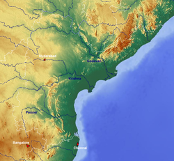 Map showing the river.
Country India States Karnataka, Andhra Pradesh Region South India Tributaries - left Jayamangali, Kunderu, Sagileru - right Chitravati, Papaghni, Cheyyeru City Nellore Mouth - location Utukuru into Bay of Bengal, Nellore, Andhra Pradesh, India - elevation 0 m (0 ft) Length 597 km (371 mi) Basin 55,213 km2 (21,318 sq mi) Discharge for Nellore (1965-1979 average), max (1991) - average 74.3 m3/s (2,624 cu ft/s) - max 1,876 m3/s (66,250 cu ft/s) - min 0 m3/s (0 cu ft/s) The Penner (also Pennar, Penna or Penneru) is a river of southern India. The Penner rises on the hill of Nandi Hills in Chikballapur District of Karnataka state, and runs north and east through the state of Andhra Pradesh to empty into the Bay of Bengal. It is 597 kilometres (371 mi) long, with a drainage basin 55,213 square kilometres (21,318 sq mi) large.[1]
Contents
Geography
The watershed of the Penner and its tributaries covers part of the southern Deccan plateau, including most of the Rayalaseema region of Andhra Pradesh and part of Karnataka. The Kolar Plateau forms the divide between the Penner watershed and those of the Kaveri, Ponnaiyar, and Palar rivers to the south. The Penner drains the northern portion of the plateau, which includes parts of Kolar and Tumkur districts in Karnataka. The Krishna River and its tributaries drain the Deccan plateau to the west and north of the Penner's watershed, and the low Erramala hills forms the northern divide of the Penner basin. The upper watershed of the Penner includes Cuddapah District, central and eastern Anantapur District, the southern part of Kurnool District, northwestern Chittoor District. The main tributaries of the Penner are the Jayamangali, Kunderu and Sagileru from the north, and the Chitravati, Papaghni and Cheyyeru from the south. The Penner then flows east through a gap in the Eastern Ghats ranges onto the plain of Coastal Andhra, where it empties into the Bay of Bengal 15 km east of Nellore at a place called Utukuru(also Vutukuru).
- Estuary
The estuary of the Penner river extends 7 km upstream from the Bay of Bengal. Tidal influence and salt water extends further upstream during the November to June dry season. Coastal dunes as high as 7 meters form around the river mouth. Upputeru tidal creek, 15 km in length, and Isakapalli lagoon, separated from the Bay of Bengal by the Isakapalli barrier island, 180 m long and up to 3 m high, form the main coastal wetlands.
The upper basin of the Penner is largely made up of ancient Archean rocks, principally granite and schist. The lower basin is made up of young sediments, including laterite and recent alluvium.
Climate
The Penner basin has a dry tropical monsoon climate. The upper basin of the Penner is semi-arid, with summer temperatures of 25–46 °C and winter temperatures of 18–28°C. Most of the rainfall is provided by the moisture-bearing southwest monsoon, which provides rain to most of India between June and September. The Penner basin lies in the rain shadow of the high Western Ghats ranges, which prevents much moisture from reaching the region. Post-monsoon cyclonic storms in the coastal region produce additional rain during September and October. The winter northeast monsoon, which provides rain between December and March, provides little rain to the upper basin and slightly more to the lower basin. It varies greatly from year to year in south India, sometimes bringing powerful cyclonic storms with flooding and high winds. The mean annual rainfall is 550 mm/year in Anantapur, and 900 mm/year in Nellore. The Penner basin suffered from a prolonged drought in the 1990s, which caused much misery among the regions farmers and generated political demands to build an aqueduct to bring water from the Krishna River to Rayalaseema.
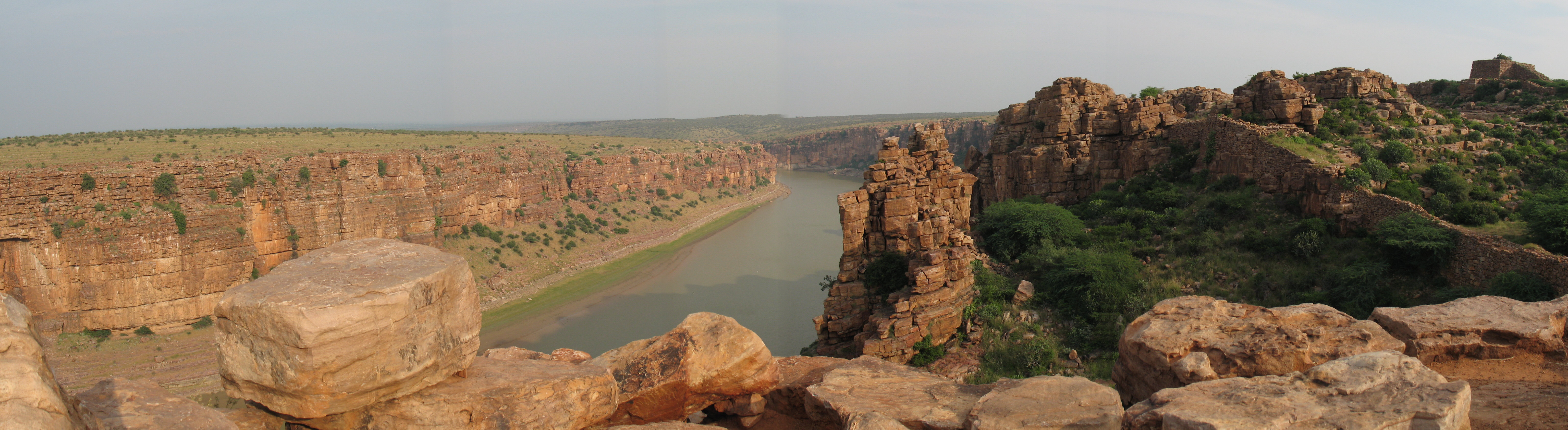
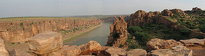 The Pennar river near the Gandikota fort
Vegetation
The upper basin was formerly covered by tropical dry forest, thorn forest, and xeric shrublands. Most of the dry tropical forest has now disappeared, due to clearance for grazing and overharvesting the forests for timber and firewood, replaced by thorny shrublands. The remnant forests of the Deccan are largely deciduous, dropping their leaves in the dry winter and spring months. The East Deccan dry evergreen forests of Coastal Andhra were evergreen, but these forests have largely been reduced to tiny remnant pockets.
Port
The small boat port of Krishnapatnam lies on Upputeru creek, and was planned to be developed into a deep-water port by 2006. Buckingham Canal, a navigable man-made waterway that runs just behind the coast, allows small boats from the Penner to get to Chennai in the south and the Krishna River delta to the north.
Literature
Telugu literature has flourished in the Penner basin which produced several well known authors and poets. Raallapalli Anantha Krishna Sharma, Vidvan Vishvam, and C. Ramakrishna Reddy are noteworthies among them. Vidhvan Vishvam's penneti paata which means "a song of River Penna" is very popular in Andhra Pradesh and in Raayala Seema in particular. Ramakrishna Reddy's "penneti kathalu" represented the tragic and cultural life of the people of Penner valley. These stories are credited to be the best of their kind with the accent of local language presented effectively.[2]
References
- ^ Garg, Santosh Kumar (1999). International and interstate river water disputes. Laxmi Publications. pp. 7–8. ISBN 9788170080688. http://books.google.com/books?id=nrcqGF3agsEC&pg=PA7. Retrieved 16 May 2011.
- ^ Raayala Seema Mukhachitram published by Seema Sahithi
External links
 Chisholm, Hugh, ed (1911). "Pennar". Encyclopædia Britannica (11th ed.). Cambridge University Press.
Hydrology of Karnataka Rivers Amarga • Amarja • Arkavathy • Bhadra • Chakra • Dandavathi • Gangavalli • Ghataprabha • Gurupura • Hemavati • Honnuhole • Kabini • Kali • Kaveri • Kedaka • Krishna • Kubja • Kumaradhara • Lakshmana Tirtha • Malaprabha • Manjira River • Netravati • Palar • Panchagangavalli • Penner • Ponnaiyar • Shambavi • Sharavathi • Shimsha • Souparnika • Tunga • Tungabhadra • Varada • Varahi • Vedavathi • VrishabhavathiWaterfalls Abbey • Barkana • Chunchanakatte • Devaragundi • Godchinamalaki • Gokak • Hebbe • Irupu • Jog • Kalhatti • Kuchikal • Magod • Mallalli • Muthyalamaduvu • Sathodi • Shivanasamudra or Cauvery • Shivganga • Unchalli • Vajrapoha • VarapohaLakes Harangi • Hebbal • Hesaraghatta • Honnamana Kere • Krishna Raja Sagara • Kukkarahalli • Pampa Sarovar • Thippagondanahalli • VibhutipuraBeaches Dams See also Kerala • Tamil Nadu • Andhra Pradesh • MaharashtraHydrology of Andhra Pradesh Rivers Champavathi • Godavari • Gosthani • Gundlakamma • Koringa • Krishna • Maldevi • Maner • Manjira • Musi • Nagavali • Palar • Penner • Sabari • Swarnamukhi • Tungabhadra • Vamsadhara • VedavathiWaterfalls Lakes Himayat Sagar • Hussain Sagar • Kolleru Lake • Lotus Pond • Nizam Sagar • Osman Sagar • Pakhal Lake • Palair lake • Shamirpet Lake • Saroornagar LakeDams Hydrology of surrounding areas Orissa • Chhattisgarh • Maharashtra • Karnataka • Tamil NaduCoordinates: 14°34′46″N 80°11′44″E / 14.57944°N 80.19556°E
Categories:- Rivers of Karnataka
- Rivers of Andhra Pradesh

Wikimedia Foundation. 2010.