- Wynad Wildlife Sanctuary
-
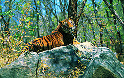
Wayanad Wildlife Sanctuary — national park — An Indian Tiger in the Sanctuary Coordinates Country India State Kerala District(s) Wayanad Time zone IST (UTC+05:30) Codes-
• Vehicle • KL-
Wayanad Wildlife Sanctuary is an animal sanctuary in Wayanad, Kerala, south India. It is on the way from Mysore to Sultan Battery. Wild animals such as Indian Bison, elephant, deer and tiger has been spotted. There are also quite a few wild birds in the sanctuary.Peacocks and Peafowl tend to be very common in the area.
Wayanad Wildlife Sanctuary is the second largest wildlife sanctuary in Kerala. It is bestowed with lush green forests and rich wildlife. Also known as the Muthanga Wildlife Sanctuary, this wildlife area houses some of the rare and endangered species of both flora and fauna.
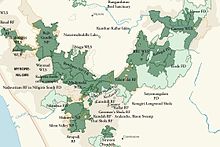
Established in 1973, the sanctuary is now an integral part of the Nilgiri Biosphere Reserve. It’s bounded by protected area network of Nagarhole and Bandipur of Karnataka in the northeast, and on the southeast by Mudumalai of Tamil Nadu.
It is part of the Wayanad plateau and the vegetation is predominantly of the south Indian moist deciduous teak forests. Also, the sanctuary has pastures of the west-coast semi-evergreen trees. The wildlife sanctuary comes under Protect Elephant and one can spot herd of elephants roaming in the area.
Elephant rides are arranged by the Forest Department,Kerala. Discovering and observing the wildlife while being atop an elephant is an enthralling and unforgettable experience.
It is spread over 344 km² and is about 16 km east of Sultan Battery, the nearest large town.
Wayanad district has the largest population of aborigine people in Kerala. The native aadivasis mainly consist of various sects like Paniyas, Kuruma s, Adiyar s, Kurichya s, Oorali s, Kattunaikkan s etc. Comprising an area of 2126 km2, Wayanad has a powerful history. Relicts and edicts found in various parts of Wayanad speak of an importatnt prehistoric era. Historians are of the view that organised human life existed in these parts, at least ten centuries before Christ.
The sanctuary is part of the Nilgiri Biosphere Reserve. The Western Ghats, Nilgiri Sub-Cluster (6,000+ km²), including all of the sanctuary, is under consideration by the UNESCO World Heritage Committee for selection as a World Heritage Site.[1]
Contents
History
Wayanad wildlife sanctuary was formed in the year 1973 and was brought under the Project Elephant in the year 1991-92. This sanctuary occupies an area of 345 km2. Waynad Wildlife Sanctuary is the second largest one in the state of Kerala. The sanctuary is separated into two disconnected parts known as the Upper Wayanad Wildlife Sanctuary in the north and Lower Wayanad Wildlife Sanctuary in the south. The area in between the two parts was originally a forest region, though it is now occupied majorly by plantations.
Flora and fauna
Flora: Moist deciduous forest consists of maruthi, karimaruthi, rosewood, venteak, vengal, chadachi, mazhukanjiram, bamboos, more, while the semi-evergreen patches comprises veteria indica., lagerstroemia, lanceolata, termianalia paniculata.
Fauna: Elephants, tigers, panthers, jungle cats, civet cats, monkeys, wild dogs, bisons, deer, bears, monitor lizards and a variety of snakes are seen.
Avian-Fauna: Peacocks, babblers, cuckoos, owls, woodpeckers, jungle fowls are a few of the various types of birds seen here.
Climate
Wayanad climate is salubrious. Average rain fall in this district is 2322 m.m. Annual rain fall in these high rain fall areas ranges from 3,000 to 4,000m.m. High velocity winds are common during the south west monsoon and dry winds blow in March-April. High altitude regions experience severe cold. This place experiences a high relative humidity which goes even up to 95 per cent during the south west monsoon period. Generally, the year is classified into four seasons, namely, cold weather, hot weather, south west monsoon and north east monsoon. The dale, 'Lakkidi', nestled among the hills of Vythiri taluk has the highest average rainfall in Kerala.
How to reach there
Location: The Wayanad Wildlife Sanctuary is located 16 km east of Sulthan Bathery in the state of Kerala.
Area: 344 km2
Route: The headquarters of the sanctuary is in Kalpetta, which is well connected to other major cities of Kerala. There are regular buses from Calicut to Kalpetta. The nearest airport and railway station is in Kozhikode. Reaching here, one can hire a taxi to reach the sanctuary.
- Nearest airport is Kozhikode - CCJ - airport - 140 km. Mysore airport at Nanjangud (76 km) is nearing completion.
- Nearest major railway stations Kozhikode - CLT - 105 km, Mysore - MYS - 99 km (no ghat section, faster access)
- The nearest railway station - Nanjangud - 76 km (only passenger trains from Mysore)
there are animals like leopard, jackal , sambar deer , porcupine
References
- ^ UNESCO, World Heritage sites, Tentative lists, Western Ghats sub cluster, Niligiris. retrieved 4/20/2007 World Heritage sites, Tentative lists
Categories:- Wildlife sanctuaries in Kerala
- Wayanad district
-
Wikimedia Foundation. 2010.


