- Ponnaiyar River
-
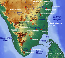
The Ponnaiyar is a river in southern India. It rises on the hill of Nandidrug in Kolar District of Karnataka state, and flows south and then east for 400 km (250 mi) through Karnataka and Tamil Nadu, emptying into the Bay of Bengal at Cuddalore.
The South Pennar River is known as Dakshina Pinakini in Kannada and Thenpennai in Tamil. It is also referred as Ponnaiyar .
The river originates in the Nandi Hills in the Kolar district of Karnataka and flows through Tamil Nadu before entering into the Bay of Bengal. It has a catchment area of 1,424 mi2. Kelavarapalli dam is built across this river near Hosur.[1] Krishnagiri dam also built across this river.
The river is dry for the most part of the year. Water flows during the monsoon season when it is fed by the southwest monsoon in catchment area and the northeast monsoon in Tamil Nadu. However this water flow raises the water table throughout the river basin and feeds numerous reservoirs/tanks. Some of the Bangalore's sewage mixes with this river via varthur lake and other channels.[2]
The sand build of the river is quite impressive, suggesting that it may have been a perennial river with much larger water flow in the past. Mention of the river is found in Sangam & Medieval (Thevaram - Bhakti cult era) literature, where it is depicted as rich with lush vegetation on its banks. There are various temples on its banks.It ends in Bay of Bengal at Cuddalore District
See also
References
Hydrology of Karnataka Rivers Amarga • Amarja • Arkavathy • Bhadra • Chakra • Dandavathi • Gangavalli • Ghataprabha • Gurupura • Hemavati • Honnuhole • Kabini • Kali • Kaveri • Kedaka • Krishna • Kubja • Kumaradhara • Lakshmana Tirtha • Malaprabha • Manjira River • Netravati • Palar • Panchagangavalli • Penner • Ponnaiyar • Shambavi • Sharavathi • Shimsha • Souparnika • Tunga • Tungabhadra • Varada • Varahi • Vedavathi • VrishabhavathiWaterfalls Abbey • Barkana • Chunchanakatte • Devaragundi • Godchinamalaki • Gokak • Hebbe • Irupu • Jog • Kalhatti • Kuchikal • Magod • Mallalli • Muthyalamaduvu • Sathodi • Shivanasamudra or Cauvery • Shivganga • Unchalli • Vajrapoha • VarapohaLakes Harangi • Hebbal • Hesaraghatta • Honnamana Kere • Krishna Raja Sagara • Kukkarahalli • Pampa Sarovar • Thippagondanahalli • VibhutipuraBeaches Dams See also Kerala • Tamil Nadu • Andhra Pradesh • MaharashtraHydrology of Tamil Nadu Rivers Adyar • Amaravathi • Arasalar • Bhavani • Cheyyar • Chittar • Cooum • Kaveri • Kedilam • Kodaganar • Kodavanar • Kokkiliyar • Kollidam • Kosasthalaiyar • Manimuthar • Nadari • Nambiyar • Nanganjiyar • Noyyal • Pachaiyar • Pahrali • Palar • Parambikulam • Ponnaiyar • Swetha • Thamirabarani • Vaigai • Vaippar • Vasishta • Vellar • VennaaruLakes Ambattur Lake • Berijam Lake • Chembarambakkam Lake • Kaliveli Lake • Kodaikanal Lake • Perumal Eri • Porur Lake • Pulicat Lake • Red Hills Lake • Sholavaram Lake • Singanallur Lake • Valankulam Lake • Veeranam Lake • Velachery Lake • Pykara • Ooty LakeWaterfalls Agaya Gangai • Ayyanar • Catherine • Courtallam • Hogenakkal • Kiliyur • Kumbakkarai • Law's Falls • Katary(Kateri) Falls • Kalhatti Falls • Kutladampatti • Monkey • Sengupathi • Siruvani • Suruli • Thalaiyar • Tirparappu • Ullakaarvi • Vaideki • VattaparaiBeaches Dams/ Reservoirs Aliyar Reservoir • Amaravathi Dam • Bhavanisagar Dam • Grand Anicut • Kamarajar Sagar Dam • Krishnagiri Dam • Mettur Dam • Mukkadal • Noyyal Oarathuppalayam • Pechiparai Reservoir • Perunchani Dam • Sathanur Reservoir • Solaiyar Dam • Vaigai Dam • Varattu Pallam DamSee also Kerala • Karnataka • Andhra PradeshCoordinates: 11°46′N 79°47′E / 11.767°N 79.783°E
Categories:- Rivers of Tamil Nadu
- Rivers of Karnataka
- India geography stubs
Wikimedia Foundation. 2010.

