- Mukkadal
-
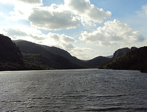 View of Mukkadal Dam
Mukkadal dam is built across the Vambaru River in the state of Tamil Nadu in southern India, 10 km (6.2 mi) from town of Nagercoil. It is a scenic place, favored as a picnic location among local residents. It was built by Sree Chithira Thirunal Balarama Varma in 1645, the King of Travancore. The dam is constructed of clay and granite stones. The depth of water behind the dam is approximately 50 ft (15 m). The reservoir supplies water for the town of Nagercoil, but ironically, not the people living near the dam.
The forest consists of soaring and lofty trees of Mesua ferrea, Bischofia javanica, Vitex Altissima to smaller trees of Dillini a species of festooning climber, shrubs, valuable herbs, variety of orchids, two types of canes and many indigenous palms and cycads. The important timbers are teak, rosewood, vengai. Various types of forest products like bamboos, reeds, canes, soft wood tamarind, lemon grass, rubber, coconut, areca nut, kadukkai, cinnamon bark, nelli, cardamom, mango, lemon varieties, jack fruit, and many medicinal plants of high value which are harvested here. The mountain range should be the end point of Western Ghats.
From tourism angle, the forest are highly enhancing with pleasant sholas, hill top forests, beautiful grasslands, panoramic valleys, top hillocks, singing streams, vast stretches of rubber plantations, valuable teak plantations and excellent climate.
The dam and reservoir are surrounded by hills on three sides. The people in the above villages and nearby villages mainly depend on this beginning point of the Western Ghats. They do mountain agriculture.
The dam can be reached through 4A, 4B, 4C, 4D, 4E, 4G, 4H, 318 buses from Nagercoil to Thuvarancaud or Thittuvilai; followed by a short ride in an auto rickshaw to the dam.
Categories:- Dams in Tamil Nadu
- Indian dam stubs

Wikimedia Foundation. 2010.