- Middlesex Canal
-
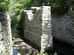
Shawsheen River Aqueduct, Middlesex Canal, Billerica/Wilmington Town Line, Massachusetts.

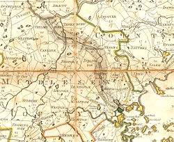
 Map of the Middlesex Canal, 1801, before it was extended south of Medford.[1]
The Middlesex Canal was a 27-mile (44-kilometre) barge canal connecting the Merrimack River with the port of Boston. When operational it was 30 feet (9.1 m) wide, and 3 feet (0.9 m) deep, with 20 locks, each 80 feet (24 m) long and between 10 and 11 feet (3.0 and 3.4 m) wide. It also had 8 aqueducts.
Contents
History
The canal was chartered on June 22, 1793 with a signature by Governor John Hancock, and was built between 1795 and 1803 under the engineering guidance of Loammi Baldwin, with the aim of opening up the vast interior of New England to merchant capital. In 1794 ground was broken at North Billerica Mills and the first boat operated on April 22, 1802.
The opening of the canal diminished the commercial viability of the port of Newburyport, Massachusetts, the outlet of the Merrimack River, since all trade from the Merrimack Valley in New Hampshire now went via the canal to Boston, rather than through the sometimes difficult to navigate river.[2]
The canal ran from Middlesex Village in East Chelmsford, Massachusetts (later renamed Lowell), through several Middlesex County towns. At first it terminated in Medford, but was later extended to Charlestown, Massachusetts with a branch near Medford Center to the Mystic River.[1] A series of other canals along the Merrimack allowed freight to be transported as far inland as Concord, New Hampshire. The water source for the canal was the Concord River at North Billerica. This was also the highest point of the canal, and is the present location of the Middlesex Canal Association's museum.
Freight boats required 18 hours from Boston up to Lowell, and 12 hours down, thus averaging 2.5 miles per hour; passenger boats were faster, at 12 and 8 hours, respectively (4 miles per hour). A roundtrip between Boston and Concord, New Hampshire usually took 7–10 days.
The canal was one of the main thoroughfares in eastern New England until the advent of the railroad. In fact, the Boston and Lowell Railroad (now a part of the MBTA Commuter Rail system) was built using the plans from the original surveys for the canal. Portions of the line follow the canal route closely, and the canal was used to transport the construction materials for the railroad.
The canal was no longer economically viable after the introduction of railroad competition, and the company collected its last tolls in 1851. Permission was given for the company to liquidate and pay the proceeds to the stockholders, and its 1793 charter was revoked in 1860. The Middlesex Turnpike, incorporated 1805, also contributed to its downfall. The proprietors proposed to convert the canal into an aqueduct to bring drinking water to Boston, but this effort was unsuccessful. Parts of the canal bed were covered by roads in the 20th century, including the Mystic Valley Parkway in portions of Medford and Winchester.
Today
Though significant portions of the Middlesex Canal are still visible, urban and suburban sprawl is quickly overcoming many of the remains. The Middlesex Canal Association has erected markers along portions of the canal's path. Prominent portions of the canal that are still visible include water-filled portions near the Baldwin House in Woburn, and dry sections in Winchester, most notably a section at the Mystic Lakes where an aqueduct was situated.
The surviving elements of the canal are the subject of a 1972 listing on the National Register of Historic Places, while the entire route, including parts that have been overbuilt, is the subject of a second listing in 2009.
References
- ^ a b http://www.medfordhistorical.org/middlesexcanal.php
- ^ Muir, Diana, Reflections in Bullough's Pond, University Press of New England, p.112
External links
- Middlesex Canal Association
- History of Middlesex Canal, with links
- New England Magazine article, January 1898
- Early Canal Transportation: The Boats of the Middlesex Canal
- Life on the Middlesex Canal, Alan Seaburg, Anne Miniver press 2009
- The incredible ditch: a bicentennial history of the Middlesex Canal By Carl Seaburg, Alan Seaburg, Thomas Dahill, Medford Historical Society (Medford, Mass., 1997)
- Paintings: Middlesex Canal by Joseph Payro 1930s
- Report of the Joint Special Committee Upon the Subject of the Flowage of Meadows on the Concord and Sudbury Rivers, by Massachusetts, General Court, published 1860. This is how the Middlesex Canal Corporation was dissolved.
U.S. National Register of Historic Places Topics Lists by states Alabama • Alaska • Arizona • Arkansas • California • Colorado • Connecticut • Delaware • Florida • Georgia • Hawaii • Idaho • Illinois • Indiana • Iowa • Kansas • Kentucky • Louisiana • Maine • Maryland • Massachusetts • Michigan • Minnesota • Mississippi • Missouri • Montana • Nebraska • Nevada • New Hampshire • New Jersey • New Mexico • New York • North Carolina • North Dakota • Ohio • Oklahoma • Oregon • Pennsylvania • Rhode Island • South Carolina • South Dakota • Tennessee • Texas • Utah • Vermont • Virginia • Washington • West Virginia • Wisconsin • WyomingLists by territories Lists by associated states Other Categories:- Canals in Massachusetts
- Canals on the National Register of Historic Places
- Historic Civil Engineering Landmarks
- History of Massachusetts
- Merrimack River
- Mystic River
- Buildings and structures on the National Register of Historic Places in Massachusetts
- Transportation in Middlesex County, Massachusetts
- Buildings and structures in Middlesex County, Massachusetts
- Geography of Middlesex County, Massachusetts
- Billerica, Massachusetts
- Lowell, Massachusetts
- Chelmsford, Massachusetts
- Wilmington, Massachusetts
- Woburn, Massachusetts
- Winchester, Massachusetts
- Medford, Massachusetts
- Somerville, Massachusetts
Wikimedia Foundation. 2010.


