Magnolia Township, Putnam County, Illinois

Magnolia Township, Putnam County, Illinois
Magnolia Township
—  Township  —
Location in Putnam County
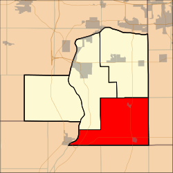
Putnam County's location in Illinois
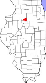
Country United States
State Illinois
County Putnam
Established November 8, 1855
Government
 - Supervisor
Area
 - Total 43.5 sq mi (112.66 km2)
 - Land 42.3 sq mi (109.55 km2)
 - Water 1.2 sq mi (3.10 km2)  3%
Population (2000)
 - Total 1,166
Time zone CST (UTC-6)
 - Summer (DST) CDT (UTC-5)

Magnolia Township is located in Putnam County, Illinois. The population was 1,166 at the 2000 census.

External links

Coordinates: 41°08′31″N 89°13′41″W / 41.14194°N 89.22806°W / 41.14194; -89.22806


Wikimedia Foundation. 2010.

Игры ⚽ Поможем написать курсовую

Look at other dictionaries:

  • Magnolia, Illinois — Village of Magnolia Location in the state of Illinois Coordinates …   Wikipedia

  • Illinois — This article is about the U.S. state of Illinois. For other uses, see Illinois (disambiguation). State of Illinois …   Wikipedia

  • McNabb, Illinois — Village of McNabb Location in the state of Illinois Coordinates …   Wikipedia

  • Mark, Illinois — Village of Mark Location in the state of Illinois Coordinates …   Wikipedia

  • List of townships in Illinois by county — This is a list of the 1,433 townships organized by counties. The remaining 17 counties are divided into 261 precincts.Each County has the option to adopt or remove a Township form of government. [60 ILCS 1/Art. 5] Each County also has the right… …   Wikipedia

  • List of places in the UTC-5 timezone — A# Abbeville, Alabama # Aberdeen, Maryland # Aberdeen, South Dakota # Abilene, Texas # Abingdon, Virginia # Abington Township, Mercer County, Illinois # Abington, Connecticut # Abington, Massachusetts # Abita Springs, Louisiana # Acton,… …   Wikipedia

  • National Register of Historic Places listings in Illinois — Map of all coordinates from Google Map of all coordinates from Bing …   Wikipedia

  • Ottawa–Streator Micropolitan Statistical Area — Location of the Ottawa Streator Micropolitan Statistical Area in Illinois The Ottawa Streator Micropolitan Statistical Area, as defined by the United States Census Bureau, is an area consisting of three counties in north central Illinois,… …   Wikipedia

  • Ottawa-Streator Micropolitan Statistical Area — The Ottawa Streator Micropolitan Statistical Area, as defined by the United States Census Bureau, is an area consisting of three counties in north central Illinois, anchored by the cities of Ottawa and Streator.As of the 2000 census, the μSA had… …   Wikipedia

  • United States — a republic in the N Western Hemisphere comprising 48 conterminous states, the District of Columbia, and Alaska in North America, and Hawaii in the N Pacific. 267,954,767; conterminous United States, 3,022,387 sq. mi. (7,827,982 sq. km); with… …   Universalium

Share the article and excerpts

Direct link
Do a right-click on the link above
and select “Copy Link”