- Eurasian Steppe
-
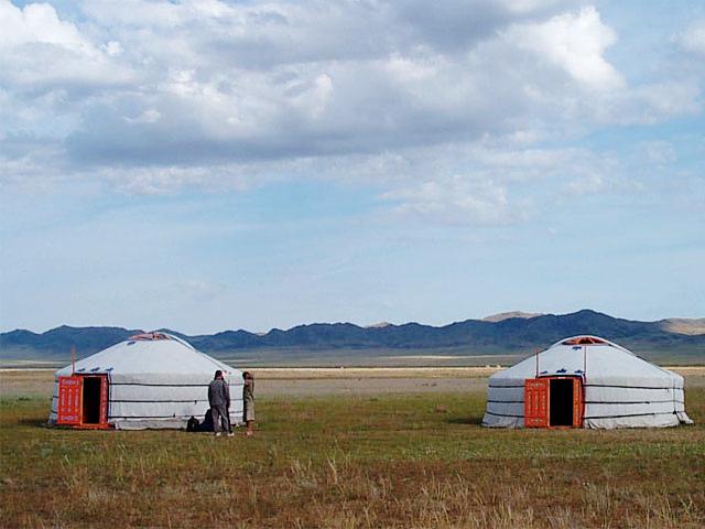
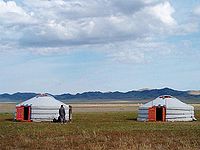 Steppe in Mongolia
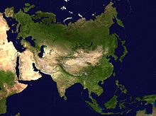
The Eurasian Steppe (also called The Steppe or The Steppes) is the vast steppe ecoregion of Eurasia in the Temperate grasslands, savannas, and shrublands Biome. It stretches from Hungary to Mongolia. The steppe has connected Europe, Central Asia, China, South Asia, and the Middle East economically, politically, and culturally through overland trade routes, most notably the Silk Road during Antiquity and the Middle Ages, and the Eurasian Land Bridge in the modern era.
Contents
Ecoregions
The World Wildlife Fund divides the Euro-Asian Steppe's temperate grasslands, savannas, and shrublands into a number of ecoregions, distinguished by elevation, climate, rainfall, and other characteristics, and home to distinct animal and plant communities and species, and distinct habitat ecosystems.
- Alai-Western Tian Shan steppe (Kazakhstan, Tajikistan, Uzbekistan)
- Altai steppe and semi-desert (Kazakhstan)
- Daurian forest steppe (China, Mongolia, Russia)
- Emin Valley steppe (China, Kazakhstan)
- Kazakh forest steppe (Kazakhstan, Russia)
- Kazakh steppe (Kazakhstan, Russia)
- Kazakh upland (Kazakhstan)
- Mongolian-Manchurian grassland (China, Mongolia, Russia)
- Pontic steppe (Moldova, Romania, Russia, Ukraine)
- Sayan Intermontane steppe (Russia)
- Selenge-Orkhon forest steppe (Mongolia, Russia)
- South Siberian forest steppe (Russia)
- Tian Shan foothill arid steppe (China, Kazakhstan, Kyrgyzstan)
Divisions
 A map of Eurasia with emphasis on deserts. Note the oval Tarim Basin at the center of the map.
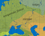
The Eurasian Steppe extends from near the mouth of the Danube River almost to the Pacific Ocean. It is bounded on the north by the forests of Russia and Siberia. There is no clear southern boundary although the land becomes increasingly dry as one moves south. The steppe narrows at two points, dividing it into three major parts.
Ural-Caspian
- The Ural Mountains extend south to a point about 400 miles northeast of the Caspian Sea. This is not a major barrier to movement, but the area near the Caspian is quite dry.
Xinjiang
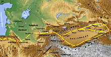
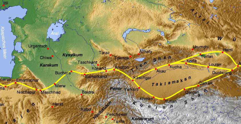
- Xinjiang: On the east side of the former Sino-Soviet border mountains extend northeast almost to the forest zone. The northern part is Dzungaria which is bounded by the Tarbagatai Mountains on the west and the Mongolian Altai Mountains on the east, neither of which is a significant barrier. Dzungaria has good grassland around the edges and a central desert. It often behaved as a westward extension of Mongolia. To the south and west of Dzungaria, and separated from it by the Tianshan Mountains, is an area about twice the size of Dzungaria, the oval Tarim Basin in the Xinjiang Uyghur Autonomous Region in China's far west. The Tarim Basin is too dry to support even a nomadic population, but around its edges rivers flow down from the mountains giving rise to a ring of cities which lived by irrigation agriculture and east-west trade. The Tarim Basin formed an island of near civilization in the center of the steppe. To the south, the Kunlun Mountains separate the Tarim Basin from the thinly-peopled Tibetan Plateau. The south of this plateau along the Himalaya Mountains was the main center of Tibetan population and civilization. To the southwest the Pamir Mountains merge into the Hindu Kush and the Himalaya Mountains.
 The Russian Steppe
Russian Steppe
- The Russian Steppe begins near the mouth of the Danube and extends northeast almost to Kazan and then southeast to the southern tip of the Ural Mountains. Its northern edge was a broad band of Forest-steppe which has now been obliterated by the conversion of the whole area to agriculture. In the southeast the Pontic-Caspian steppe extends between the Black Sea and Caspian Sea to the Caucasus Mountains. In the west, the Great Hungarian Plain is an island of steppe separated from the main steppe by the mountains of Transylvania. North of the Black Sea, the Crimean peninsula has some interior steppe and ports on the south coast which link the Russian steppe to the civilizations of the Mediterranean basin.
 The Kazakh Steppe in the north with the Tarim Basin (Takhlamakan) and Dzungaria
Kazakh Steppe
- The Kazakh Steppe proper extends from the Urals to Dzungaria. To the south it grades off into semi-desert and desert which is interrupted by two great rivers, the Amu Darya (Oxus) and Syr Darya (Jaxartes) which flow northwest into the Aral Sea and provide irrigation agriculture. In the southeast is the densely populated Fergana Valley and west of it the great oasis cities of Tashkent, Samarkand and Bukhara along the Zarafshan River. The southern area has a complex history (see Central Asia and Greater Iran) while in the north the Kazakh Steppe proper was relatively isolated from the main currents of history.
Mongol Steppe
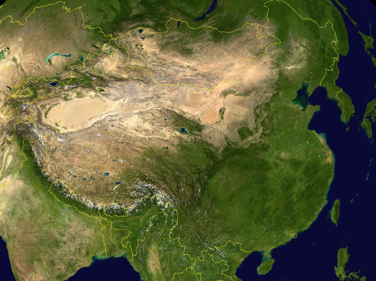
- The Mongol Steppe includes both the Outer Mongolia that we see on maps and also modern Chinese province of Inner Mongolia. The two are separated by a relatively dry area marked by the Gobi Desert. South of Mongolia is the Gansu or Hexi Corridor, a belt of moderately dense population that connects China proper with the Tarim Basin. The Gansu Corridor was the main route of the Silk Road. When Chinese dynasties were strong they would extend a thin finger of power along the Gansu corridor toward the Tarim Basin. To the southwest the Qilian Mountains separate the Gansu Corridor from the Tibetan Plateau. To the south is a region of hills and mountains, and to the southeast, the Central China Plain.
 China and surrounding regions. Note the oval Tarim Basin, the dryer area separating Inner and Outer Mongolia and the projection of steppe into Manchuria
Manchuria
- "Manchuria" is a special case. Westerners tend to think of Manchuria as including not only modern Northeast China but also China west of the Greater Khingan Mountains, which is in fact a part of Inner Mongolia. The Pacific coast and the northern part of Greater Manchuria were only annexed by Russia in 1860. The Southeastern quarter of it, including the Yalu river valley and the eastern portion of modern-day Jilin used to be controlled by ancient Korean dynasties such as Goguryeo and Balhae. In the south, the Liaotung Peninsula has been Chinese for at least 1,000 years, since the demise of Goguryeo. It is connected to China Proper by a narrow coastal strip, the Shanhaiguan or 'mountain-sea-gate'. South of the Khingan Mountains and north of the Taihang Mountains the Liao Xi steppe extends from Inner Mongolia into Manchuria. The central area of forest-steppe was inhabited by pastoral and agricultural peoples. To the north and east was a thin population of hunting tribes of the Siberian type. For half of the last two thousand years north China was ruled by dynasties originating in Manchuria. In the last 200 years the whole area has become populated by Han Chinese.
Language, Religion, Trade and Warfare
Trade: The major centers of population and high culture in Eurasia are Europe, the Middle East, India and China. For some purposes it is useful to treat Greater Iran as a separate region. With the exception of Europe and the Middle East, these regions are connected by the steppe. The Silk Road started in the Guanzhong region of China and ran west along the Gansu Corridor to the Tarim Basin. From there it went southwest to Greater Iran and turned southeast to India or west to the Middle East and Europe. A minor branch went northwest along the great rivers and north of the Caspian Sea to the Black Sea. When faced with a rich caravan the steppe nomads could either rob it, or tax it, or hire themselves out as guards. Economically these three forms of taxation or parasitism amounted to the same thing. Trade was usually most vigorous when a strong empire controlled the steppe and reduced the number of petty chieftains preying on trade. The silk road first became significant and Chinese silk began reaching the Roman Empire about the time that the Emperor Wu of Han pushed Chinese power west to the Tarim Basin.
Biologically the steppe population is Mongoloid in the east and from the Tarim Basin becomes increasingly Caucasoid as one moves west. The Kalmyks are an isolated Mongoloid population west of the Volga.
Language: On one hypothesis of the origin of the Indo-European languages, their common ancestor is thought to have originated on the Russian steppe. The Tocharians were an early branch of Indo-European in the Tarim Basin. At the beginning of written history the entire steppe population west of Dzungaria spoke Iranian languages. From about 500 AD the Turkic Languages replaced the Iranian languages first on the steppe and later in the oases north of Iran. The reasons for this are poorly understood. After 1077 a group of Turkic speakers pushed into Anatolia and founded the modern nation of Turkey. The Mongolic languages are in Mongolia. In Manchuria one finds Tungusic languages and some others.
Religion: If the Kurgan hypothesis of Indo-European origins is accepted, then the earliest hypothesised steppe religion would have been the mythology of the Indo-Europeans. Later, Tangriism was introduced by Turko-Mongol nomads. Nestorianism and Manichaeism spread to the Tarim Basin and into China but they never became an established majority religion. Buddhism spread from India north to the Tarim Basin and found a new home in China. By about 1400 the entire steppe west of Dzungaria had adopted Islam. By about 1600 Islam was established in the Tarim Basin while Dzungaria and Mongolia had adopted Tibetan Buddhism.
Animals: There seems to be little information about steppe ecology before the coming of nomadic pastoralism. The primary animals raised were sheep and goats with fewer cattle than one might expect. Camels were used in the drier areas for transport as far west as Astrakhan. There were some Yaks along the edge of Tibet. The horse was used for transportation and warfare.
The Horse was first domesticated on the Russian or Kazakh steppe sometime before 3000 BC, but it took a long time for the Horse archer to develop and the process is not fully understood. The stirrup does not seem to have been completely developed until 300 AD. (see Stirrup, Saddle, Composite Bow, Domestication of the horse and related articles.)
Agriculture: The nomads would occasionally tolerate colonies of peasants on the steppe in the few areas where farming was possible. These were often captives who grew grain for their nomadic masters. Along the fringes there were areas that could be used for either plowland or grassland. These alternated between one and the other depending on the relative strength of the nomadic and agrarian heartlands. In the last few hundred years the Russian steppe and much of Inner Mongolia has fallen to the plow. The fact that most of the Russian steppe is not irrigated implies that it was held in grass due to the military strength of the nomads.
Warfare: There was a great deal of petty raiding all over the steppe. This is connected to the ease with which a defeated enemy's flocks can be driven away, which makes raiding profitable. In relation to sedentary societies, the horse gave the nomads the supreme advantage of mobility. Horsemen can raid a village and be gone with their loot before a land army can be gathered. When confronted with superior infantry, horsemen can simply ride away and regroup where there are no soldiers. Outside of Europe and parts of the Middle East, agrarian societies had difficulty raising a sufficient number of war horses and often had to buy them from their nomadic enemies. Nomads could not easily be pursued onto the steppe since the steppe could not easily support a land army. If the Chinese sent an army into Mongolia, the nomads would flee and come back when the Chinese ran out of supplies. But the steppe nomads were relatively few and their rulers had difficulty holding together enough clans and tribes to field a large army. Except for Ginghis Khan, they could not take walled cities. If they conquered an agricultural area they often lacked the skills to administer it. If they tried to hold agrarian land they gradually absorbed the higher civilization of their subjects, lost their barbarian skills and were either absorbed by their subjects or driven out.
Relations with Neighbors: Along the northern fringe the nomads would collect tribute from and blend with the forest tribes (see Khanate of Sibir, Buryats). From about 1240 to 1480 Russia paid tribute to the Golden Horde. South of the Kazakh steppe the nomads blended with the sedentary population, partly because the Middle East and Iran have significant areas of steppe and pastoralism. There was a sharp cultural divide between Mongolia and China and almost constant warfare from the dawn of history until 1757. The nomads collected large amounts of tribute from the Chinese and several Chinese dynasties were of steppe origin. Perhaps because of the mixture of agriculture and pastoralism in Manchuria its inhabitants knew how to deal with both nomads and settled populations and were able to conquer much of northern China when both Chinese and Mongols were weak.
See also
- Puszta
- Great Alföld
- Little Alföld
- Pontic steppe
Bibliography
- Plano Carpini, John of, "History of the Mongols," in Christopher Dawson, (ed.), Mission to Asia, Toronto: University of Toronto Press, 2005, pp. 3–76.
- Barthold, W., Turkestan Down to the Mongol Invasion, T. Minorsky, (tr.), New Delhi: Munshiram Manoharlal Publishers, 1992.
- Christian, David, A History of Russia, Central Asia and Mongolia, Volume 1: Inner Eurasia from Prehistory to the Mongol Empire’, Malden MA, Oxford, UK, Carlton, Australia: Blackwell Publishing 1998.
- Fletcher, Joseph F., Studies on Chinese and Islamic Inner Asia, Beatrice Forbes Manz, (ed.), Aldershot, Hampshire: Variorum, 1995, IX.
- Grousset, Rene, The Empire of the Steppes: a History of Central Asia, Naomi Walford, (tr.), New Brunswick, NJ: Rutgers University Press, 1970.
- Krader, Lawrence, "Ecology of Central Asian Pastoralism," Southwestern Journal of Anthropology, Vol. 11, No. 4, (1955), pp. 301–326.
- Lattimore, Owen, "The Geographical Factor in Mongol History," in Owen Lattimore, (ed.), Studies in Frontier History: Collected Papers 1928-1958, London: Oxford University Press, 1962, pp. 241–258.
- Sinor, Denis, "The Inner Asian Warrior," in Denis Sinor, (Collected Studies Series), Studies in Medieval Inner Asia, Aldershot, Hampshire: Ashgate, Variorum, 1997, XIII.
- Sinor, Denis, "Horse and Pasture in Inner Asian History," in Denis Sinor, (Collected Studies Series), Inner Asia and its Contacts with Medieval Europe, London: Variorum, 1977, II.
Categories:- Eurasian steppe
- Temperate grasslands, savannas, and shrublands
- Ecoregions of Asia
- Ecoregions of Europe
- Central Asia
- Grasslands of Asia
- Grasslands of Europe
- Grasslands of Russia
- Horse archer civilizations and empires
- Social history of India
- History of Pakistan
- Landforms of Asia
- Landforms of Europe


Wikimedia Foundation. 2010.