- Epsom and Ewell
-
Borough of Epsom and Ewell — Non-metropolitan district, Borough — Epsom and Ewell shown within Surrey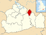
Sovereign state United Kingdom Constituent country England Region South East England Non-metropolitan county Surrey Status Non-metropolitan district, Borough Admin HQ Epsom Incorporated 1 April 1974 Government – Type Non-metropolitan district council – Body Epsom and Ewell Borough Council – Leadership Alternative - Sec. 31 (Independent) – MPs Chris Grayling Area – Total 13.2 sq mi (34.07 km2) Area rank 304th (of 326) Population (2010 est.) – Total 74,300 – Rank 298th (of 326) – Density 5,648.3/sq mi (2,180.8/km2) – Ethnicity 91.3% White
3.8% S.AsianTime zone GMT (UTC0) – Summer (DST) BST (UTC+1) ONS code 43UC OS grid reference TQ205605 Website epsom-ewell.gov.uk Epsom and Ewell is a local government district with borough status in Surrey, England, covering the town of Epsom and the village of Ewell. The borough was formed as an urban district in 1894, and was known as Epsom until 1934. It was made a municipal borough in 1937. The district was considered for inclusion in Greater London in 1965 but was left unaltered by the London Government Act 1963 and the Local Government Act 1972 in 1974.[1] However, despite being outside modern Greater London the borough was in the Metropolitan Police District until it was transferred to Surrey Police in 2000. In the May 2011 elections, the borough was held by the Epsom and Ewell Residents Association with 26 seats, Liberal Democrats with 6 seats and both the Labour and Conservatives with 3 seats.
Contents
History
Epsom and Ewell lie on the spring line on the north face of the North Downs where pervious chalk meets impervious London clay and a series of springs form. In Ewell the springs which form the Hogsmill River are evident, those in Epsom less so. The springs attracted prehistoric people and remains have been found, mostly in Ewell and particularly near the Hogsmill. In Roman times the road now known as Stane Street, from London to Chichester, passed through Epsom and Ewell. Roman remains have been found in Ewell suggesting a sizeable settlement. Epsom and Ewell have Saxon names: Ewell takes its name from the spring in the centre of the village and Epsom, or Ebbisham, is the enclosure of Ebbi. A Saxon cemetery in The Grove in Ewell was excavated in the 1930s.
In medieval times the area was covered by three manors: Cuddington, which was owned by the Codington family; Epsom, which belonged to Chertsey Abbey; and Ewell, associated with Merton Priory. In 1538 the village of Cuddington was destroyed to make way for Henry VIII's Nonsuch Palace and its parks. Henry died before the palace was complete but it was visited by his daughter Queen Elizabeth. It was demolished in 1682.
Epsom became a spa in the early 17th century when a spring containing Epsom salts was discovered on the Common. Its popularity with London society brought visits from Samuel Pepys and Nell Gwynne, the development of shops and inns and the oldest spa assembly rooms in England. This stands at the western end of Epsom High Street. Horse racing on Epsom Downs began during the spa period, but it was not until the Oaks was run in 1789 and the Derby the following year that it took on its present form. The first grandstand was built in 1830 and Queen's Stand in 1995. The 1927 grandstand has been demolished and a new complex is to open in 2019.
Many large houses were built in Epsom during and after the spa period. St Martin's Church was rebuilt in 1825 and partly rebuilt in 1908 and the clock tower in the centre of the town replaced the earlier watchhouse in 1847. Ewell saw less change and, although now surrounded by suburbia, retains much of village character. Its medieval church was replaced by the present Victorian one in 1848, but the medieval tower stands in the churchyard.
The Pre-Raphaelite painters, John Everett Millais and William Holman Hunt, had connections with both Ewell and Cuddington and used local scenes as backgrounds for a number of paintings, notably 'Ophelia' by Millais and 'The Light of the World' by Hunt.
In 1995 Epsom and Ewell twinned with Chantilly in northern France, another racing town. Links are coordinated by Epsom and Ewell Town Twinning Association.[2]
Transport
Railway stations in the borough include Epsom, Ewell East, Ewell West and Stoneleigh. Epsom Downs and Tattenham Corner stations sit on the borough borders. All stations except Epsom are in London Travelcard zone 5 and 6. The borough is just north of, and entirely within, the M25 motorway. London Gatwick Airport is 20 miles south from Epsom. Numerous buses serve the town, and Epsom Coaches and its bus division Quality Line are based in Epsom.
Politics
 This is the current composition of the borough Council with the Residents Association dominating with 26 seats
Epsom and Ewell is one of the few councils dominated by a group not linked to a national political party. Epsom and Ewell Residents Association has dominated the council since the foundation of the borough. Epsom and Ewell Parliamentary Constituency is one of the most Conservative seats and contains the entirety of the borough. As the population is not large enough for a full seat, it has also contained neighbouring areas. Since 1997 it also contains Ashtead, part of the Mole Valley district. Before boundaries changed in 1997 the constituency instead contained Banstead to the east, which is part of Reigate and Banstead borough.
Previous election results are as follows:
Overall control Conservative Labour Lib Dem Epsom and Ewell Residents Association 2011 Residents 3 3 6 26 2007 Residents 2 - 11 25 2003 Residents 2 3 6 27 1999 Residents - 3 9 27 1995 Residents - 3 3 33 1991 Residents - 3 6 30 1987 Residents - 3 1 35 1983 Residents - 3 2 34 1979 Residents - 3 - 37 1976 Residents - 3 - 37 1973 Residents - 3 - 37 Education
Epsom and Ewell has several secondary schools, Glyn Technology School, Epsom and Ewell High School, Rosebery School, Blenheim High School and Linden Bridge School. In addition it also has two private schools, Epsom College and Ewell Castle
Further education
Higher Education
References
 Districts of South East England
Berkshire 
Buckinghamshire Aylesbury Vale • Chiltern • Milton Keynes • South Bucks • Wycombe
East Sussex Brighton and Hove • Eastbourne • Hastings • Lewes • Rother • Wealden
Hampshire Basingstoke and Deane • East Hampshire • Eastleigh • Fareham • Gosport • Hart • Havant • New Forest • Portsmouth • Rushmoor • Southampton • Test Valley • Winchester
Isle of Wight Kent Ashford • Canterbury • Dartford • Dover • Gravesham • Maidstone • Medway • Sevenoaks • Shepway • Swale • Thanet • Tonbridge and Malling • Tunbridge Wells
Oxfordshire Surrey Elmbridge • Epsom and Ewell • Guildford • Mole Valley • Reigate and Banstead • Runnymede • Spelthorne • Surrey Heath • Tandridge • Waverley • Woking
West Sussex Adur • Arun • Chichester • Crawley • Horsham • Mid Sussex • Worthing
Categories:- Local government in Surrey
- Epsom and Ewell
- Non-metropolitan districts of Surrey
- Local government districts of South East England


Wikimedia Foundation. 2010.