- Mole Valley
-
For the Westminster Parliament constituency, see Mole Valley (UK Parliament constituency) and Epsom and Ewell (UK Parliament constituency)
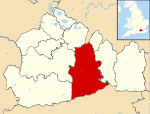
Mole Valley District — Non-metropolitan district — Mole Valley shown within Surrey Sovereign state United Kingdom Constituent country England Region South East England Non-metropolitan county Surrey Status Non-metropolitan district Admin HQ Dorking Incorporated 1 April 1974 Government - Type Non-metropolitan district council - Body Mole Valley District Council - Leadership Alternative - Sec.31 (Conservative / Independent) - MPs Paul Beresford
Chris GraylingArea - Total 99.7 sq mi (258.3 km2) Area rank 153rd (of 326) Population (2010 est.) - Total 84,600 - Rank 274th (of 326) - Density 848.3/sq mi (327.5/km2) - Ethnicity 97.4% White Time zone GMT (UTC0) - Summer (DST) BST (UTC+1) ONS code 43UE OS grid reference TQ0496458567 Website molevalley.gov.uk Mole Valley is a local government district in Surrey, England. Its council is based in Dorking.
The district, named after the River Mole, was formed on 1 April 1974, under the Local Government Act 1972, by a merger of the urban districts of Dorking and Leatherhead and most of the Dorking and Horley Rural District. The two towns in the district are Dorking and Leatherhead. The largest villages are Ashtead, Fetcham and Great Bookham, all of which are in the northern third of the district.
Contents
Civil parishes
These are[1]
- Abinger
- Betchworth
- Brockham
- Buckland
- Capel
- Charlwood
- Headley
- Holmwood
- Leigh
- Mickleham
- Newdigate
- Ockley
- Wotton
Villages
- Abinger Common
- Abinger Hammer
- Ashtead
- Beare Green
- Betchworth
- Brockham
- Capel
- Charlwood
- Coldharbour
- Fetcham
- Friday Street
- Forest Green
- Great Bookham
- Headley
- Holmbury St Mary
- Leigh
- Little Bookham
- Mickleham
- Newdigate
- Ockley
- Westcott
- Westhumble
Towns
Partisan composition of Mole Valley District Council
See also: Mole Valley local electionsMole Valley District Council is usually elected by thirds: That is, approximately one-third of the members are re-elected at each election, each serving four year terms, with one year out of every four not having Council elections.
The Council was, however, re-elected whole in 2000 after wholesale boundary changes to the Wards.
Traditionally, despite Mole Valley Constituency's strongly Conservative leaning, Mole Valley District Council is usually in no overall control. There have been two exceptions to this: 1980-82 - Independent control and 2006-10 - Conservative control. Mole Valley currently has a Conservative-Independent Coalition, while the Liberal Democrats are the largest single party and official opposition.
Year Conservative Labour Lib Dem Independent Other 1999 17 1 16 7 0 2000 19 1 14 7 0 2002 18 1 15 3 4 2003 19 1 15 6 0 2004 19 0 17 5 0 2006 23 0 15 3 0 2007 22 0 16 3 0 2010 18 0 17 6 (5 Ashtead Independs + 1 Leatherhead Independent) 0 2010 17 0 18 6 (5 Ashtead Independs + 1 Leatherhead Independent) 0[2] Party control
- 1974–1980: No overall control
- 1980–1982: Independent control
- 1982–2006: No overall control
- 2006–2010: Conservative
- 2010 – Present: No overall control
Environmental concerns
In May 2006, a report commissioned by British Gas [1] showed that housing in Mole Valley produced the twentieth highest average carbon emissions in the country at 6,928 kg of carbon dioxide per dwelling.
See also: Energy efficiency in British housingIn 2008 a group of residents got together and formed The Green Mole Forum [2] with the aim of promoting sustainable development in Mole Valley both by providing a hub to help residents, and to lobby the council to undertake more sustainable policies.
Emergency services
Mole Valley is served by these emergency services:
- Surrey Police. Dorking Police Station is the lead station in Mole Valley Division, Leatherhead Police Station is only used for minor issues now, and is only part time.
- South East Coast Ambulance Service The district has two Ambulance Stations one in North Holmwood (1 mile south of Dorking)and the other in Leatherhead.
- Surrey Fire & Rescue Service, The district has two Fire Stations one in North Holmwood and the other in Leatherhead.
- SURSAR, The district is covered by Surrey Search & Rescue
- Hospital, Each town has a small NHS Hospital with no A&E. They are used for outpatients and rehabilitation.
Sources
- Local elections, 1999
- Local elections, 2000
- Local elections, 2002
- Local elections, 2003
- Local elections, 2004
References
External links
 Districts of South East England
Berkshire 
Buckinghamshire Aylesbury Vale • Chiltern • Milton Keynes • South Bucks • Wycombe
East Sussex Brighton and Hove • Eastbourne • Hastings • Lewes • Rother • Wealden
Hampshire Basingstoke and Deane • East Hampshire • Eastleigh • Fareham • Gosport • Hart • Havant • New Forest • Portsmouth • Rushmoor • Southampton • Test Valley • Winchester
Isle of Wight Kent Ashford • Canterbury • Dartford • Dover • Gravesham • Maidstone • Medway • Sevenoaks • Shepway • Swale • Thanet • Tonbridge and Malling • Tunbridge Wells
Oxfordshire Surrey Elmbridge • Epsom and Ewell • Guildford • Mole Valley • Reigate and Banstead • Runnymede • Spelthorne • Surrey Heath • Tandridge • Waverley • Woking
West Sussex Adur • Arun • Chichester • Crawley • Horsham • Mid Sussex • Worthing
Coordinates: 51°18′57.68″N 0°29′37.31″W / 51.3160222°N 0.4936972°W
Categories:- Local government in Surrey
- Mole Valley
- Non-metropolitan districts of Surrey
- Local government districts of South East England
Wikimedia Foundation. 2010.


