- Charlwood
-
Coordinates: 51°09′24″N 0°13′34″W / 51.156571°N 0.226146°W
Charlwood 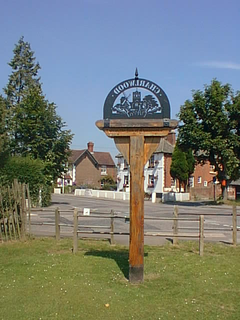
Charlwood village sign on 'The Rec' with The Rising Sun pub in the background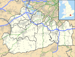
 Charlwood
Charlwood shown within SurreyPopulation 2,027 (2001 Census) OS grid reference TQ241411 - London 28 mi (45 km) N District Mole Valley Shire county Surrey Region South East Country England Sovereign state United Kingdom Post town Horley Postcode district RH6 Dialling code 01293 Police Surrey Fire Surrey Ambulance South East Coast EU Parliament South East England UK Parliament Mole Valley List of places: UK • England • Surrey Charlwood is a village and civil parish in the Mole Valley district of Surrey, England. It is immediately northwest of London Gatwick Airport in West Sussex, close west of Horley and north of Crawley. The historic county boundary between Surrey and Sussex ran to the south of Gatwick Airport. Boundaries were reformed in 1974 so that the county boundary between Surrey and West Sussex, delineated by the Sussex Border Path, now runs along the northern perimeter of the airport, and the southern extent of Charlwood. The village has more crown post timber framed houses than any other village in Britain
The village anciently lay within the Reigate hundred. In 2001, Charlwood had a population of 2,027.[1]
Contents
Governance
Charlwood is located in Mole Valley and together with Hookwood, it has its own parish council.[2] It was moved from Surrey to West Sussex in a local government reorganisation and is notable for having an eponymous act of parliament - the Charlwood and Horley Act 1974[3] - to move it back into Surrey.
Features
Charlwood is the home of the Lowfield Heath Windmill which was moved from the village of Lowfield Heath when it was threatened with demolition in the 1970s to make room for the expansion of Gatwick Airport.[4]
The village is centred around the "rec" which now contains an excellent redeveloped children's playground. The rec is the home of Charlwood F.C., Charlwood Village F.C. and Ifield Cricket Club.
The village used to have its own cricket club (Charlwood C.C.) which for many years was seen playing on both Saturdays and Sundays on the green. In latter years the club only put out one side, on a Sunday but managed to achieve the distinction of not losing a single game for over 3 seasons (between 1989 and 1991) - this record still stands. The cricket ground became known as "The Field of Dreams" in the media after the famous film.[citation needed] The club closed in 2002.
The village has its own infant school, a small number of shops and three pubs - The Greyhound, The Rising Sun and The Half Moon - and a restaurant, Limes Bistro, as well as two hotels and numerous Bed and Breakfasts on its outskirts. It has a sister village in Hookwood, at the southern tip of the A217, between Charlwood and Horley.
SSSI
Glover's Wood, a Site of Special Scientific Interest is located close west of Charlwood, and is noted for its bluebell displays in springtime.
Record-breaking temperature
On 19 July 2006, it was believed that Charlwood had recorded the highest UK July temperature of 36.3°C (97. 3°F); however, it was later confirmed that Wisley had beaten it with 36.5 °C (98 °F).[5]
Notable people
- Don Charlwood, Australian-born author and aviator, visited the village during the war and discovered that his ancestors were buried in the cemetery there.
- Phil Creswick of the boyband Big Fun was born in Charlwood
- Barry Sheene MBE, former British World Champion of Grand Prix motorcycle racing lived in Charlwood before his move to Australia in the late 1980s[6]
- David Sheppard, former Bishop of Liverpool and England cricket captain was brought up in Charlwood.
- E H Shepard, the illustrator of Winnie the Pooh lived for a time with his sister in Charlwood
- Charles Cardell lived at Dumbledene estate in Charlwood.
See also
References
- ^ Census data
- ^ Charlwood Parish Council
- ^ "The Charlwood and Horley Act 1974". OPSI. 8th February 1974. http://www.opsi.gov.uk/RevisedStatutes/Acts/ukpga/1974/cukpga_19740011_en_1. Retrieved 2008-12-31.
- ^ "Lowfield Heath Windmill, Rectory Lane, Charlwood, Mole Valley, Surrey". English Heritage. http://www.imagesofengland.org.uk/details/default.aspx?pid=2&id=430357. Retrieved 2008-05-17.
- ^ BBC News article about the record breaking weather
- ^ Surrey online downloaded 4/11/07
External links
Neighbouring areas of Surrey 
Brockham Leigh Sidlow Newdigate 
Horley  Charlwood

Rusper Crawley Lowfield Heath Towns, villages and hamlets in the Mole Valley District of Surrey, England 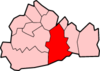 Abinger · Abinger Common · Abinger Hammer · Ashtead · Beare Green · Betchworth · Brockham · Buckland · Capel · Charlwood · Coldharbour · Dorking · Fetcham · Friday Street · Great Bookham · Headley · Holmbury · Holmwood · Leatherhead · Leigh · Little Bookham · Mickleham · Newdigate · Ockley · Westcott · Westhumble ·Categories:
- Villages in Surrey
- Mole Valley
- Civil parishes in Surrey


Wikimedia Foundation. 2010.