- Mid Sussex
-
Mid Sussex District — Non-metropolitan district — Mid Sussex shown within West Sussex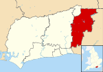
Sovereign state United Kingdom Constituent country England Region South East England Non-metropolitan county West Sussex Status Non-metropolitan district Admin HQ Haywards Heath Incorporated 1 April 1974 Government - Type Non-metropolitan district council - Body Mid Sussex District Council - Leadership Leader & Cabinet (Conservative) - MPs Nick Herbert
Francis Maude
Nicholas SoamesArea - Total 129 sq mi (334.02 km2) Area rank 130th (of 326) Population (2010 est.) - Total 132,500 - Rank 152nd (of 326) - Density 1,027.4/sq mi (396.7/km2) - Ethnicity 95.3% White
1.6% S.Asian
1.0% Black
1.2% Mixed RaceTime zone GMT (UTC0) - Summer (DST) BST (UTC+1) Website midsussex.gov.uk Mid Sussex is a local government district in the English county of West Sussex. It contains the towns of East Grinstead, Haywards Heath and Burgess Hill.
The district was created on 1 April 1974, and replaced the urban districts of Cuckfield, Burgess Hill, and East Grinstead and nearly all of Cuckfield Rural. These districts had previously been under East Sussex.
The District borders the Tandridge district of Surrey to the north, Lewes district and Wealden district to the east, and Brighton and Hove to the south, all in East Sussex, and Horsham district and Crawley to the west and northwest respectively, both of which are in West Sussex.[1]
Civil parishes
Within the Mid Sussex District are the following civil parishes:[2]
Parish Type Area (Hectare) Population (2001) Pop Density /Hectare Albourne Parish Council 773 600 0.78 Ardingly Parish Council 1609 1833 1.14 Ashurst Wood Parish Council 251 1771 7.05 Balcombe Parish Council 2105 1765 0.84 Bolney Parish Council 1479 1209 0.82 Burgess Hill Town Council 947 28803 30.42 Cuckfield Parish Council 432 3266 7.57 Cuckfield Rural Parish Council 3869 1574 0.41 East Grinstead Town Council 2443 23942 9.80 Fulking Parish Council 628 250 0.40 Hassocks Parish Council 1088 6821 6.27 Haywards Heath Town Council 975 22800 23.38 Horsted Keynes Parish Council 1581 1507 0.95 Hurstpierpoint and Sayers Common Parish Council 2030 6264 3.09 Lindfield Parish Council 224 5394 24.07 Lindfield Rural Parish Council 1981 2644 1.33 Newtimber Parish Council 695 96 0.14 Poynings Parish Council 666 287 0.43 Pyecombe Parish Council 887 200 0.23 Slaugham Parish Council 2432 2226 0.92 Turners Hill Parish Council 1390 1849 1.33 Twineham Parish Council 784 271 0.35 West Hoathly Parish Council 2139 2121 0.99 Worth Parish Council 1995 9888 4.96 Mid Sussex Total 33403 127381 3.81 Local politics
The parliamentary constituency of Mid Sussex covers most (but not all) of the District, and is currently held by the Conservative Party. The incumbent Member of Parliament (MP) is Nicholas Soames, the grandson of former Prime Minister Sir Winston Churchill, and a former junior minister in the Government of John Major (1990–97). In the 2005 general election, Nicholas Soames held the seat with 48.0% of the popular vote, a 1.8% increase; the Liberal Democrat candidate Ms Serena Tierney took 36.1% of votes, a 5.0% increase; the Labour Party candidate Robert Fromant received 12.7% of the vote, a 6.1% decrease; and the United Kingdom Independence Party candidate Harold Piggott received 3.2%, a 0.7% increase. The turnout for Mid Sussex was 68.6% (49,494 people voted) up 3.7% from 2001.
References
- ^ http://www.midsussex.gov.uk/page.cfm?pageid=2858
- ^ "2001 Census: West Sussex – Population by Parish". West Sussex County Council. http://www.westsussex.gov.uk/communityandliving/census2001/pop_parish_summary.pdf. Retrieved 26 March 2009.
Towns Villages and hamlets Albourne · Ansty · Ardingly · Ashurst Wood · Balcombe · Bolney · Clayton · Copthorne · Crawley Down · Cuckfield · Fulking · Goddards Green · Handcross · Hassocks · Hickstead · Horsted Keynes · Hurst Wickham · Hurstpierpoint · Keymer · Lindfield · Newtimber · Pease Pottage · Poynings · Pyecombe · Saddlescombe · Sayers Common · Scaynes Hill · Sharpthorne · Slaugham · Staplefield · Turners Hill · Twineham · Walstead · Warninglid · West HoathlyCivil parishes Ceremonial county of West Sussex West Sussex Portal Boroughs or districts Adur District · Arun District · Chichester District · Crawley Borough · Horsham District · Mid Sussex District · Worthing Borough
Major settlements Arundel · Bognor Regis · Burgess Hill · Chichester · Crawley · East Grinstead · Haywards Heath · Horsham · Lancing · Littlehampton · Midhurst · Petworth · Selsey · Shoreham-by-Sea · Southwick · Steyning · Worthing
See also: List of civil parishes in West SussexRivers Topics History · Geography · (South Downs, South Downs National Park, Weald) · Museums · Places · Parliamentary constituencies · Schools
 Districts of South East England
Berkshire 
Buckinghamshire Aylesbury Vale • Chiltern • Milton Keynes • South Bucks • Wycombe
East Sussex Brighton & Hove • Eastbourne • Hastings • Lewes • Rother • Wealden
Hampshire Basingstoke and Deane • East Hampshire • Eastleigh • Fareham • Gosport • Hart • Havant • New Forest • Portsmouth • Rushmoor • Southampton • Test Valley • Winchester
Isle of Wight Kent Ashford • Canterbury • Dartford • Dover • Gravesham • Maidstone • Medway • Sevenoaks • Shepway • Swale • Thanet • Tonbridge and Malling • Tunbridge Wells
Oxfordshire Surrey Elmbridge • Epsom and Ewell • Guildford • Mole Valley • Reigate and Banstead • Runnymede • Spelthorne • Surrey Heath • Tandridge • Waverley • Woking •
West Sussex Coordinates: 51°1′14.4″N 0°8′14.38″W / 51.020667°N 0.1373278°W
Categories:- Mid Sussex
- Local government in West Sussex
- Non-metropolitan districts of West Sussex
- Local government districts of South East England


Wikimedia Foundation. 2010.