- River Arun
-
For other uses, see Arun River (disambiguation).
Arun River 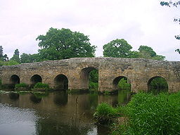 Stopham Bridge near Pulborough
Country England County West Sussex Districts Horsham, Arun Tributaries - right River Rother Towns Horsham, Arundel, Littlehampton Source - location St Leonard's Forest, Horsham, West Sussex - elevation 125 m (410 ft) Mouth - location Littlehampton, Arun, West Sussex - elevation 0 m (0 ft) Basin 376 sq mi (974 km2) Discharge for Pallingham Quay - average 4.78 m3/s (169 cu ft/s) - max 78.5 m3/s (2,772 cu ft/s) - min 0.31 m3/s (11 cu ft/s) Discharge elsewhere (average) - Alfoldean 1.84 m3/s (65 cu ft/s) The Arun is a river in the English county of West Sussex. Its source is a series of small streams (known locally as ghylls or gills) in the St Leonard's Forest area, to the east of Horsham. It flows through Horsham to the west and at Nowhurst is joined by North River (aka River Ockle), whose source is the heights of Leith Hill and Holmbury Hill in Surrey[citation needed].
It flows through Arundel and past the castle, and flows into the English Channel at Littlehampton. Its main tributary is the western River Rother. The Arun local government district in West Sussex is named after it. The river runs for approximately 41 km (25 mi) from source to the sea, and is one of the faster flowing in England[citation needed]. The river is tidal as far inland as Pallingham Quay, 18.25 miles upstream from Littlehampton[citation needed].
Contents
History
As early as 150 AD, the Arun was recorded as the Trisantonis in Ptolemy's Geography, with later records substantiating the connection.[1] Trisantonis is thought to be a Brythonic word for 'the trespasser', indicating the river's tendency to flood land near to the river. There is also a theory that the Arun may have been known as the Trisantonis in its lower reaches close to the sea, but known as the Arnus (from the Brythonic 'Arno' meaning run or flow). So the Arnus would mean 'the flowing one'. It is possible that the town of Arundel may mean Arno-dell, or dell of the flowing river.[1] In the Middle Ages the river was known as the Tarrant,[2] evidenced by Tarrant Street in modern Arundel, later becoming known as the Arun after the town or the Rape of Arundel[citation needed].
The mouth of the river has not always been at Littlehampton. Until the later fifteenth century it joined the River Adur at Lancing some ten miles to the east before entering the sea. This estuary became blocked with shingle by the eastward drift of the tides, pushing the Adur towards Shoreham-by-Sea, while the Arun broke out at Worthing, Goring and Ferring at various times, until it formed its present estuary at Littlehampton between 1500 and 1530.[3] The Arun was linked to the canal network by the Wey and Arun Canal, opened in 1816 and closed in 1871, which is currently being renovated. The river had been made navigable to New Bridge on the A272 between Wisborough Green and Billingshurst by 1787, by the Arun Navigation Company. By 1791 ships of 200 tons could reach Arundel, where goods were transferred to sailing barges which could use wind and tide to travel upriver. There was no towpath on the river. The river was a toll-free navigation as far as Pallingham, by ancient royal charter, causing financial difficulties for the navigation company, which was obliged by act of parliament to maintain the river.[4] The Rother Navigation joined the Arun near Stopham Bridge, a fine medieval stone bridge built in AD 1423, which carried the heavy traffic on the A283 road until a new bridge was built beside it in the 1980s. The central arch was raised in 1822 to allow masted barges to pass. Littlehampton and its harbour were guarded from naval attack by Littlehampton Redoubt on the western bank at the mouth of the river, completed in 1854, which is now screened from the open sea by Climping sand dunes. This fort replaced a seven gun battery on the east bank built in 1759, which now has a recreational crazy golf course on top of it.
The river was abandoned as a navigation by a warrant issued as part of the Railway and Canal Traffic Act of 1888. The River Lark in Suffolk was the only other river navigation abandoned at that time.[5]
See also
- Rivers of the United Kingdom
- R.H. Goodsall, The Arun and Western Rother
- P.A.L. Vine, London's Lost Route to the Sea, Middleton Press, 1996
- P.A.L. Vine, London's Lost Route to Midhurst, The Earl of Egremont's Navigation
References
- ^ a b The Roman Map of Britain
- ^ Victoria County History of Sussex Index of Volume 5 Retrieved 2009-10-25
- ^ P.A.L. Vine, London's Lost Route to the Sea, Middleton Press, 1996, page 20
- ^ P.A.L. Vine, London's Lost Route to Midhurst, The Earl of Egremont's Navigation pp. 51-54
- ^ The Canals of Eastern England, (1977), John Boyes and Ronald Russell, David and Charles, ISBN 978-0715374153
External links
Categories:- Rivers of Sussex
- River navigations in the United Kingdom
- Important Plant Areas in England

Wikimedia Foundation. 2010.