- Devils Island Light
-
Devils Island Light 
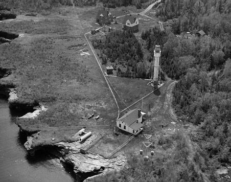
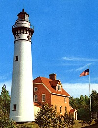
Location Devils Island, Wisconsin Coordinates 47°04′48″N 90°43′42″W / 47.08°N 90.72833°WCoordinates: 47°04′48″N 90°43′42″W / 47.08°N 90.72833°W Year first lit 1901 Automated 1978 Foundation Concrete Construction Cast iron Tower shape Cylindrical Free Standing[1] Height Tower - 80 feet (24 m)[2] Focal height Focal plane - 1,007 feet (307 m)[3] Original lens 3rd order Fresnel lens[4][5] Range 13 statute miles (21 km) Characteristic Red, Flashing, 10 sec ARLHS number USA-228 USCG number 7-15565 The Devils Island Lighthouse is a lighthouse located on Devils Island, one of the Apostle Islands, in Lake Superior in Ashland County, Wisconsin, near the city of Bayfield.
Currently owned by the National Park Service and part of the Apostle Islands National Lakeshore, it was added to the National Register of Historic Places in 1977, as reference number 77000145. Listed in the Library of Congress Historic American Buildings Survey, WI-324. Several other structures in the vicinity are also listed in HABS.
The original third order Fresnel lens manufactured by Henry-Lepaute was removed by the U.S. Coast Guard in 1989, but a new third order Fresnel lens was replaced by the N.P.S. in 1992.[6]
The site originally had a 10-inch (250 mm) steam whistle in a fog signal building. That was removed in 1925, and "a much improved air-operated diaphone fog signal" was accomplished. In 1928, a diesel-powered electrical generator was installed, and the light intensity increased to 300,000 candela for the white flash and 180,000 candela for the red.[7]
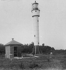
A previous skeletal, wooden structure was constructed in 1891 has since been demolished. Historical brick Queen Anne style keepers quarters (1896) are collocated with the current lighthouse. Also on the premises were two oil houses, a tramway, a brownstone tramway engine building, a dock, wooden boathouse (1 mile distant) and a radio beacon.[6]
Contents
Getting there
Most of the Apostle Islands light stations may be reached on the Apostle Islands Cruise Service[8] water taxi or by private boat during the summer. During the Annual Apostle Island Lighthouse Celebration[9] ferry tour service is available for all the lighthouses. In the tourist season, volunteer park rangers are on the many of the islands to greet visitors.[10]
See also
References
- ^ Pepper, Terry. "Database of Tower Design". Seeing the Light. terrypepper.com. http://www.terrypepper.com/lights/lists/towertype.htm.
- ^ Pepper, Terry. "Database of Tower Heights". Seeing the Light. terrypepper.com. http://www.terrypepper.com/lights/lists/towers.htm.
- ^ Pepper, Terry. "Database of Focal Heights". Seeing the Light. terrypepper.com. http://www.terrypepper.com/lights/lists/focalheight.htm.
- ^ "Historic Light Station Information and Photography: Wisconsin". United States Coast Guard Historian's Office. http://www.uscg.mil/history/weblighthouses/LHWI.asp.
- ^ Pepper, Terry. "Database of Original Lenses". Seeing the Light. terrypepper.com. http://www.terrypepper.com/lights/lists/distribution.htm.
- ^ a b National Park Service, Maritime Heritage Project, Inventory of Historic Light Stations - Wisconsin
- ^ Terry Pepper, Seeing the Light, Devil's Island Light.
- ^ Apostle Islands Cruise Service.
- ^ Apostle Island Lighthouse Celebration.
- ^ Wobser, David, La Pointe Light, boatnerd.com Originally in Great Laker Magazine.
Specialized Additional reading
- Devils Island Light Station. Lighthouse Digest (Jan 1999), pp. 14–15.
- Havighurst, Walter (1943) The Long Ships Passing: The Story of the Great Lakes, Macmillan Publishers.
- Oleszewski, Wes, Great Lakes Lighthouses, American and Canadian: A Comprehensive Directory/Guide to Great Lakes Lighthouses, (Gwinn, Michigan: Avery Color Studios, Inc., 1998) ISBN 0-932212-98-0.
- Pepper, Terry. "Seeing the Light: Lighthouses on the western Great Lakes". http://www.terrypepper.com/lights/index.htm.
- Wright, Larry and Wright, Patricia, Great Lakes Lighthouses Encyclopedia Hardback (Erin: Boston Mills Press, 2006) ISBN 1-55046-399-3.
 USCG archive photo
External links
 USCG archive photo
- Aerial photos of Devils Island Light, Marina.com.
- Anderson, Kraig. Lighthouse friends Devil's Island Light article.
- Library of Congress Historic American Buildings Survey Survey number HABS WI-324
- Library of Congress Historic American Buildings Survey Survey number HABS WI-324-A
- National Park Service, Maritime History Project, Inventory of Historic Light Stations - Wisconsin, Devils Island Light.
- NPS - Devils Island Light Station
- Terry Pepper, Seeing the Light, Devil's Island Light.
- Rowlett, Russ. "Lighthouses of the United States: Eastern Wisconsin". The Lighthouse Directory. University of North Carolina at Chapel Hill. http://www.unc.edu/~rowlett/lighthouse/wi.htm.
- (PDF) Light List, Volume VII, Great Lakes. Light List. United States Coast Guard. http://www.navcen.uscg.gov/pdf/lightLists/LightList%20V7.pdf.
- Wobser, David, Devil's Island Lights, boatnerd.com. originally in Great Laker Magazine.
Lighthouses of Wisconsin See also: List of lighthouses in WisconsinLake Superior Apostle Islands • Ashland Harbor Breakwater • Chequamegon Point • Devils Island • Gull Island • La Pointe • Michigan Island • Outer Island • Raspberry Island • Sand Island • Wisconsin Point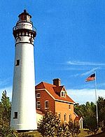
Lake Michigan Algoma Pierhead • Baileys Harbor • Baileys Harbor Range • Boyer Bluff • Cana Island • Chambers Island • Eagle Bluff • Grassy Island Range • Green Bay Harbor Entrance • Kenosha North Pier • Kenosha Southport • Kewaunee Pierhead • Kevich • Manitowoc Breakwater • Milwaukee Breakwater • Milwaukee Pierhead • North Point • Peshtigo Reef • Pilot Island • Plum Island Range • Pottawatomie • Rawley Point • Sherwood Point • Sturgeon Bay Canal • Sturgeon Bay Canal North Pierhead • Wind PointLake Winnebago Historical (lost) lights Dunlap Reef Range Front • Manitowoc Main • Manitowoc North Pierhead • Plum Island Range Front • Racine North Pierhead • Racine Reef LightU.S. National Register of Historic Places Topics Lists by states Alabama • Alaska • Arizona • Arkansas • California • Colorado • Connecticut • Delaware • Florida • Georgia • Hawaii • Idaho • Illinois • Indiana • Iowa • Kansas • Kentucky • Louisiana • Maine • Maryland • Massachusetts • Michigan • Minnesota • Mississippi • Missouri • Montana • Nebraska • Nevada • New Hampshire • New Jersey • New Mexico • New York • North Carolina • North Dakota • Ohio • Oklahoma • Oregon • Pennsylvania • Rhode Island • South Carolina • South Dakota • Tennessee • Texas • Utah • Vermont • Virginia • Washington • West Virginia • Wisconsin • WyomingLists by territories Lists by associated states Other Categories:- Buildings and structures in Ashland County, Wisconsin
- Lighthouses on the National Register of Historic Places
- Lighthouses in Wisconsin
- National Register of Historic Places in Wisconsin
- Visitor attractions in Ashland County, Wisconsin
- Buildings and structures completed in 1901

Wikimedia Foundation. 2010.