Sand Island Light (Wisconsin)

Sand Island Light (Wisconsin)

Infobox_Lighthouse
name= Sand Island Light
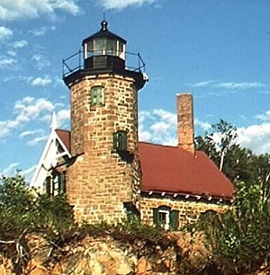

caption =
location = Sand Island, Wisconsin
coordinates = coord|47|00|12|N|90|56|12|W|region:US_type:landmark
yearlit = 1881
automated = 1921
yeardeactivated = 1933-1980
foundation = Stone
construction = Sandstone
shape = Octagonal
height = 40 feet (12 m)
lens = Fourth order Fresnel lens
range = 7 statute miles (11 km)
characteristic = White, flashing, 6 s
ARLHS = USA-722
USCG = 7-15580
The Sand Island Lighthouse is a lighthouse located on the northern tip of Sand Island, one of the Apostle Islands, in Lake Superior in Bayfield County, Wisconsin, near the city of Bayfield.

Currently owned by the National Park Service and part of the Apostle Islands National Lakeshore, it was added to the National Register of Historic Places in 1977, part of reference number 77000145. Listed in the Library of Congress Historic American Buildings Survey, WI-313.

Attached to the lighthouse is a Norman gothic keepers quarters.

ee also

*Apostle Islands Lighthouses

External links

* [http://www.nps.gov/apis/sand.htm NPS - Sand Island Light Station]
* [http://www.lighthousefriends.com/light.asp?ID=689 Lighthouse friends article]
* [http://www.cr.nps.gov/maritime/park/sandisl.htm NPS - Inventory of Historic Light Stations - Wisconsin]
* [http://www.navcen.uscg.gov/pubs/LightLists/V7COMPLETE.PDF Volume 7, USCG Lightlist (PDF)]
* [http://hdl.loc.gov/loc.pnp/hhh.wi0238 Library of Congress Historic American Buildings Survey] Survey number HABS WI-313


Wikimedia Foundation. 2010.

Игры ⚽ Нужен реферат?

Look at other dictionaries:

  • Sand Island (Wisconsin) — Sand Island is one of the Apostle Islands, in northern Wisconsin, in Lake Superior, and is part of the Apostle Islands National Lakeshore. The Sand Island Light is located on the island.and Island Pioneer SettlersMuch of the land in the Bayfield… …   Wikipedia

  • Outer Island Light — Location Wisconsin Coordinates 47°04′36″N 90°25′00″W …   Wikipedia

  • Michigan Island Light — The current tower Location Michigan Island, Wisconsin Coordinates …   Wikipedia

  • Devils Island Light — Location Devils Island, Wisconsin Coordinates 47°04′48″N 90°43′42″W …   Wikipedia

  • Chambers Island Light — Location Chambers Island, Wisconsin Coordinates …   Wikipedia

  • Round Island Light (Michigan) — Round Island Light Location Mackinac County, Michigan Coordinates …   Wikipedia

  • Manitou Island Light Station — Undated USCG photo of the station Location Manitou Island, Michigan Year first constructed 1861 Year first lit 1862 Automated 1978 Construction Iron Tower shape …   Wikipedia

  • Currituck Beach Light — Currituck Beach Lighthouse Location Corolla, North Carolina Coordinates …   Wikipedia

  • Middle Bay Light — in Mobile Bay, near Mobile, Alabama. Location Mobile Harbor, Mobile Bay, Alabama Coordinates …   Wikipedia

  • Charlevoix South Pier Light Station — Charlevoix Lighthouse Location Charlevoix County, Michigan Coordinates …   Wikipedia

Share the article and excerpts

Direct link
Do a right-click on the link above
and select “Copy Link”